| Name | Address | Coordinates | Government recognition (CRHP №) |  | Image |
| McAbee Fossil Beds Heritage Site | Highway 97
Near Cache Creek BC | 50°47′50″N 121°08′28″W / 50.7972°N 121.141°W / 50.7972; -121.141 (McAbee Fossil Beds Heritage Site) | British Columbia (19023) | |  |
| Clinton Pioneer Cemetery | 7456 Old Clinton Cemetery Road
Clinton BC | 51°05′40″N 121°35′16″W / 51.0944°N 121.5877°W / 51.0944; -121.5877 (Clinton Pioneer Cemetery) | Clinton municipality (21454) | | 
Upload Photo |
| Wilson Residence and Sheds | Steelhead Provincial Park
Savona BC | 50°45′24″N 120°51′57″W / 50.7568°N 120.8657°W / 50.7568; -120.8657 (Wilson Residence and Sheds) | British Columbia (18044) | |
Upload Photo |
| Ray Farm Cabin |
Near Clearwater BC | 52°03′30″N 120°09′22″W / 52.0584°N 120.156°W / 52.0584; -120.156 (Ray Farm Cabin) | British Columbia (18072) | |
Upload Photo |
| Ray Farm Residence |
Near Clearwater BC | 52°03′31″N 120°09′22″W / 52.0586°N 120.156°W / 52.0586; -120.156 (Ray Farm Residence) | British Columbia (18046) | |
Upload Photo |
| Hat Creek Ranch | 4061 Sea to Sky Highway, Thompson-Nicola Regional District
Hat Creek BC | 50°53′07″N 121°24′32″W / 50.8854°N 121.409°W / 50.8854; -121.409 (Hat Creek Ranch) | British Columbia (2856) | |
Upload Photo |
| B.C. Sheep Breeders Building | 961 Lorne Street
Kamloops BC | 50°40′31″N 120°18′58″W / 50.6753°N 120.316°W / 50.6753; -120.316 (B.C. Sheep Breeders Building) | Kamloops municipality (11832) | |  |
| Cattle Car and Caboose | 7th Avenue at Front Street
Kamloops BC | 50°40′43″N 120°19′23″W / 50.6786°N 120.323°W / 50.6786; -120.323 (Cattle Car and Caboose) | Kamloops municipality (12788) | |  |
| CNR Station | 500 Lorne Street
Kamloops BC | 50°40′44″N 120°19′47″W / 50.6788°N 120.3297°W / 50.6788; -120.3297 (CNR Station) | Kamloops municipality (11836) | |
Upload Photo |
| Hayden House | 566 4th Avenue
Kamloops BC | 50°40′21″N 120°19′55″W / 50.6726°N 120.332°W / 50.6726; -120.332 (Hayden House) | Kamloops municipality (12787) | | 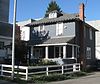 |
| Inland Cigar Factory | 295 1st Avenue
Kamloops BC | 50°40′32″N 120°20′20″W / 50.6755°N 120.339°W / 50.6755; -120.339 (Inland Cigar Factory) | Kamloops municipality (12793) | |  |
| Kamloops Chinese Cemetery | 850 Lombard Street
Kamloops BC | 50°40′41″N 120°21′35″W / 50.6781°N 120.3597°W / 50.6781; -120.3597 (Kamloops Chinese Cemetery) | Kamloops municipality (12794) | |
Upload Photo |
| McIntosh Memorial | 500 block Columbia Street West
Kamloops BC | 50°40′23″N 120°21′11″W / 50.673°N 120.353°W / 50.673; -120.353 (McIntosh Memorial) | Kamloops municipality (11834) | |  |
| Memorial Arena | 740 Victoria Street
Kamloops BC | 50°40′35″N 120°19′23″W / 50.6763°N 120.323°W / 50.6763; -120.323 (Memorial Arena) | Kamloops municipality (12137) | |  |
| Naval Ammunition Depot Bunkers | 1455 McGill Road
Kamloops BC | 50°40′31″N 120°23′02″W / 50.6753°N 120.384°W / 50.6753; -120.384 (Naval Ammunition Depot Bunkers) | Kamloops municipality (12795) | | 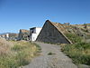 |
| Old Kamloops Bank of Commerce | 118 Victoria Street
Kamloops BC | 50°40′35″N 120°20′19″W / 50.6763°N 120.3387°W / 50.6763; -120.3387 (Old Kamloops Bank of Commerce) | Kamloops municipality (12792) | |
Upload Photo |
| Old Kamloops Courthouse | 7 Seymour Street West
Kamloops BC | 50°40′30″N 120°20′20″W / 50.6751°N 120.339°W / 50.6751; -120.339 (Old Kamloops Courthouse) | Kamloops municipality (12791) | | 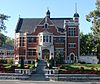 |
| Pioneer Cemetery | 780 Lorne Street
Kamloops BC | 50°40′39″N 120°19′13″W / 50.6776°N 120.3204°W / 50.6776; -120.3204 (Pioneer Cemetery (Kamloops)) | Kamloops municipality (12785) | |
Upload Photo |
| Plaza Hotel | 405 Victoria Street
Kamloops BC | 50°40′32″N 120°19′55″W / 50.6756°N 120.332°W / 50.6756; -120.332 (Plaza Hotel) | Kamloops municipality (11833) | |  |
| St. Andrew's on the Square | 159 Seymour Street
Kamloops BC | 50°40′29″N 120°20′13″W / 50.6748°N 120.337°W / 50.6748; -120.337 (St. Andrew's on the Square) | Kamloops municipality (11835) | |  |
| Stoodley Residence | 79 Nicola Street West
Kamloops BC | 50°40′22″N 120°20′28″W / 50.6729°N 120.341°W / 50.6729; -120.341 (Stoodley Residence) | Kamloops municipality (12798) | | 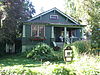 |
| Stuart Wood School | 245 St. Paul Street
Kamloops BC | 50°40′25″N 120°20′10″W / 50.6736°N 120.336°W / 50.6736; -120.336 (Stuart Wood School) | Kamloops municipality (12790) | |
Upload Photo |
| Tom Bones House | 328 Royal Avenue
Kamloops BC | 50°41′12″N 120°21′36″W / 50.6867°N 120.36°W / 50.6867; -120.36 (Tom Bones House) | Kamloops municipality (12796) | | 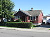 |
| W. A. G. Marlatt House | 155 St. Paul Street West
Kamloops BC | 50°40′30″N 120°20′35″W / 50.675°N 120.343°W / 50.675; -120.343 (W. A. G. Marlatt House) | Kamloops municipality (12797) | |  |
| William W. Bishop House | 619 Nicola Street
Kamloops BC | 50°40′19″N 120°19′34″W / 50.672°N 120.326°W / 50.672; -120.326 (William W. Bishop House) | Kamloops municipality (12786) | | 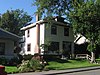 |
| Wilson House | 115 Tranquille Road
Kamloops BC | 50°41′05″N 120°21′09″W / 50.6846°N 120.3526°W / 50.6846; -120.3526 (Wilson House) | Kamloops municipality (12799) | |
Upload Photo |
| Steelhead Cemetery |
Near Savona BC | 50°45′20″N 120°51′58″W / 50.7556°N 120.866°W / 50.7556; -120.866 (Steelhead Cemetery) | British Columbia (18071) | |
Upload Photo |

 French
 Deutsch


