| Name | Address | Coordinates | Government recognition (CRHP №) |  | Image |
| Mackie Lake House | 7808 Kidston Road
Coldstream BC | 50°13′26″N 119°15′33″W / 50.2239°N 119.2592°W / 50.2239; -119.2592 (Mackie Lake House) | British Columbia (5612) | | 
Upload Photo |
| Bank of Commerce | 3117 30th Avenue
Vernon BC | 50°15′50″N 119°16′23″W / 50.2638°N 119.2730°W / 50.2638; -119.2730 (Bank of Commerce) | Vernon municipality (17108) | |  |
| Bank of Montreal | 2908 32nd Street
Vernon BC | 50°15′48″N 119°16′26″W / 50.2633°N 119.2738°W / 50.2633; -119.2738 (Bank of Montreal) | Vernon municipality (17068) | |  |
| Campbell House | 2203 30th Avenue
Vernon BC | 50°15′50″N 119°15′44″W / 50.2638°N 119.2621°W / 50.2638; -119.2621 (Campbell House) | Vernon municipality (17063) | |  |
| First Crowell House | 2805 27th Street
Vernon BC | 50°15′46″N 119°15′58″W / 50.2627°N 119.266°W / 50.2627; -119.266 (First Crowell House) | Vernon municipality (17062) | | 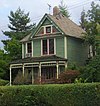 |
| Fred Galbraith House | 3203 26th Street
Vernon BC | 50°15′57″N 119°15′54″W / 50.2659°N 119.265°W / 50.2659; -119.265 (Fred Galbraith House) | Vernon municipality (17101) | |
Upload Photo |
| Girouard Cabin and Park | 3001 35th Street
Vernon BC | 50°15′51″N 119°16′48″W / 50.2642°N 119.28°W / 50.2642; -119.28 (Girouard Cabin and Park) | Vernon municipality (17102) | |
Upload Photo |
| Land and Agricultural Company Building | 2923 30th Avenue
Vernon BC | 50°15′50″N 119°16′12″W / 50.264°N 119.27°W / 50.264; -119.27 (Land and Agricultural Company Building) | Vernon municipality (17066) | |  |
| Mohr House | 2301 32nd Avenue
Vernon BC | 50°15′56″N 119°15′47″W / 50.2655°N 119.263°W / 50.2655; -119.263 (Mohr House) | Vernon municipality (17064) | |
Upload Photo |
| Owens House | 2000 37th Avenue
Vernon BC | 50°16′07″N 119°15′29″W / 50.2685°N 119.258°W / 50.2685; -119.258 (Owens House) | Vernon municipality (17070) | |
Upload Photo |
| Park School | 2704 Highway #6
Vernon BC | 50°15′38″N 119°16′16″W / 50.2606°N 119.271°W / 50.2606; -119.271 (Park School) | Vernon municipality (17103) | |
Upload Photo |
| Pleasant Valley Cemetery | 4311 Pleasant Valley Road
Vernon BC | 50°16′32″N 119°15′05″W / 50.2756°N 119.2515°W / 50.2756; -119.2515 (Pleasant Valley Cemetery) | Vernon municipality (17104) | |
Upload Photo |
| Second Crowell House | 1800 32nd Avenue,
Vernon BC | 50°15′54″N 119°15′22″W / 50.2651°N 119.256°W / 50.2651; -119.256 (Second Crowell House) | Vernon municipality (17067) | | 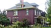 |
| Smith House | 1705 32nd Avenue
Vernon BC | 50°15′57″N 119°15′18″W / 50.2658°N 119.255°W / 50.2658; -119.255 (Smith House) | Vernon municipality (17061) | |
Upload Photo |
| Spinks/Ellison House | 2159 36th Avenue
Vernon BC | 50°16′06″N 119°15′36″W / 50.2682°N 119.26°W / 50.2682; -119.26 (Spinks/Ellison House) | Vernon municipality (17069) | |
Upload Photo |
| St. James Catholic Church | 2607 27th Street
Vernon BC | 50°15′42″N 119°15′58″W / 50.2618°N 119.266°W / 50.2618; -119.266 (St. James Catholic Church) | Vernon municipality (17105) | |
Upload Photo |
| The Rock Park | 3210 Centennial Drive
Vernon BC | 50°15′53″N 119°16′48″W / 50.2648°N 119.28°W / 50.2648; -119.28 (The Rock Park) | Vernon municipality (17107) | |
Upload Photo |
| Urquhart House | 2501 23rd Avenue
Vernon BC | 50°15′32″N 119°15′54″W / 50.2588°N 119.265°W / 50.2588; -119.265 (Urquhart House) | Vernon municipality (17065) | |  |
| Vernon CPR Station | 3101 29th Street
Vernon BC | 50°15′53″N 119°16′08″W / 50.2646°N 119.269°W / 50.2646; -119.269 (Vernon CPR Station) | Vernon municipality (17106) | |
Upload Photo |
| Vernon Federal Building | 3101 32nd Avenue
Vernon BC | 50°15′58″N 119°16′19″W / 50.266°N 119.272°W / 50.266; -119.272 (Vernon Federal Building) | Federal (9590) | |
Upload Photo |

 French
 Deutsch


