
 French
 Deutsch
Laoda
Laoda | |
|---|---|
Village | |
 Laoda Location in West Bengal, India  Laoda Laoda (India) | |
| Coordinates: 22°36′55″N 87°43′42″E / 22.6154°N 87.7283°E | |
| Country | |
| State | West Bengal |
| District | Paschim Medinipur |
| Population (2011) | |
| • Total | 1,328 |
| Languages | |
| • Official | Bengali, English |
| Time zone | UTC+5:30 (IST) |
| PIN | 721211 |
| Telephone/STD code | 03225 |
| Lok Sabha constituency | Ghatal |
| Vidhan Sabha constituency | Daspur |
| Website | paschimmedinipur |
Laoda is a village in the Daspur I CD block in the Ghatal subdivision of the Paschim Medinipur district in the state of West Bengal, India.
Geography[edit]


5miles
M: municipal city/ town, R: rural/ urban centre, H: historical/ religious centre
Owing to space constraints in the small map, the actual locations in a larger map may vary slightly
Location[edit]
Laoda is located at 22°36′55″N 87°43′42″E / 22.6154°N 87.7283°E.
Area overview[edit]
Ishwar Chandra Vidyasagar, scholar, social reformer and a key figure of the Bengal Renaissance, was born at Birsingha on 26 September 1820.[1][2]
Ghatal subdivision, shown in the map alongside, has alluvial soils. Around 85% of the total cultivated area is cropped more than once.[3] It has a density of population of 1,099 per km2, but being a small subdivision only a little over a fifth of the people in the district reside in this subdivision. 14.33% of the population lives in urban areas and 86.67% lives in the rural areas.[4]
Note: The map alongside presents some of the notable locations in the subdivision. All places marked in the map are linked in the larger full screen map.
Demographics[edit]
According to the 2011 Census of India, Laoda had a total population of 1,328, of which 650 (49%) were males and 678 (50%) were females. There were 166 persons in the age range of 0–6 years. The total number of literate persons in Laoda was 872 (75.04% of the population over 6 years).[5]
Culture[edit]
David J. McCutchion mentions the Banka Rai temple as a nava-ratna with smooth rekha turrets, measuring 18’ 4" square, built in 1801, having rich terracotta facade.[6]
Laoda picture gallery[edit]
-
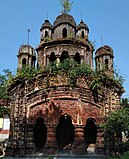 Banka Rai nava-ratna temple
 -
 Terracotta panel in Banka Rai temple


References[edit]
- ^ Murshid, Ghulam. "Vidyasagar, Pundit Iswar Chandra". Banglapedia. Retrieved 24 July 2016.
- ^ "Ishwar Chandra Vidyasagar". www.whereincity.com. Retrieved 24 July 2016.
- ^ "District Human Development Report Paschim Medinipur, 2011". page 27-28. Department of Planning and Statistics, Government of West Bengal. Retrieved 10 September 2020.
- ^ "District Statistical Handbook Paschim Medinipur, 2013". Table 2.2, 2.4 (a). Department of Planning and Statistics. Retrieved 10 September 2020.
- ^ "CD block Wise Primary Census Abstract Data(PCA)". West Bengal – District-wise CD blocks. Registrar General and Census, India. Retrieved 21 August 2020.
- ^ McCutchion, David J., Late Mediaeval Temples of Bengal, first published 1972, reprinted 2017, page 53. The Asiatic Society, Kolkata, ISBN 978-93-81574-65-2
