
 French
 Deutsch
Jalchak
Jalchak | |
|---|---|
Village | |
 Jalchak Location in West Bengal, India  Jalchak Jalchak (India) | |
| Coordinates: 22°14′37″N 87°40′20″E / 22.243611°N 87.672194°E | |
| Country | |
| State | West Bengal |
| District | Paschim Medinipur |
| Population (2011) | |
| • Total | 6,793 |
| Languages | |
| • Official | Bengali, English |
| Time zone | UTC+5:30 (IST) |
| PIN | 721155 |
| Telephone/STD code | 03222 |
| Lok Sabha constituency | Ghatal |
| Vidhan Sabha constituency | Pingla |
| Website | paschimmedinipur |
Jalchak is a village in the Pingla CD block in the Kharagpur subdivision of the Paschim Medinipur district in the state of West Bengal, India.
Geography[edit]


5miles
Madhyabar
Railway Settlement
M: municipal city/ town, CT: census town, R: rural/ urban centre, H: historical/ religious centre, F: facilities
Owing to space constraints in the small map, the actual locations in a larger map may vary slightly
Location[edit]
Jalchak is located at 22°14′37″N 87°40′20″E / 22.243611°N 87.672194°E.
Area overview[edit]
Kharagpur subdivision, shown partly in the map alongside, mostly has alluvial soils, except in two CD blocks in the west – Kharagpur I and Keshiary, which mostly have lateritic soils. Around 74% of the total cultivated area is cropped more than once.[1] With a density of population of 787 per km2nearly half of the district's population resides in this subdivision. 14.33% of the population lives in urban areas and 86.67% lives in the rural areas.[2]
Note: The map alongside presents some of the notable locations in the subdivision. All places marked in the map are linked in the larger full screen map.
Demographics[edit]
According to the 2011 Census of India, Jalchak had a total population of 6,793, of which 3,620 (53%) were males and 3,173 (47%) were females. There were 825 persons in the age range of 0–6 years. The total number of literate persons in Jalchak was 5,049 (84.60% of the population over 6 years).[3]
Education[edit]
Jalchak Nateswari Netaji Vidyayatan is a Bengali-medium co-educational institution established in 1949. The school has facilities for teaching from class V to class XII. It has a library with 4,000 books, 10 computers and a playground.[4]
Culture[edit]
David J. McCutchion mentions the Ramchandra temple of Bhattacharya family as a pancha ratna having rekha turrets with curved cornices and porch on three arches, richly terracotta decorated, built in 1817, measuring 18’ 2" square.[5]
Jalchak picture gallery[edit]
-
 Pancha-ratna Ram Chandra temple in a perilous condition
 -
 Ram Chandra temple
 -
 Ram Chandra temple has exquisite terracotta work
 -
 Terracotta panels
 -
 Pancha-ratna Radha Krishna temple in perilous condition
 -
 The deity in the garbhagriha
 -
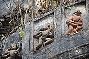 Terracotta panel


Healthcare[edit]
There is a primary health centre at Jalchak, with 10 beds.[6]
References[edit]
- ^ "District Human Development Report Paschim Medinipur, 2011". page 27-28. Department of Planning and Statistics, Government of West Bengal. Retrieved 10 September 2020.
- ^ "District Statistical Handbook Paschim Medinipur, 2013". Table 2.2, 2.4 (a). Department of Planning and Statistics. Retrieved 10 September 2020.
- ^ "CD block Wise Primary Census Abstract Data(PCA)". West Bengal – District-wise CD blocks. Registrar General and Census, India. Retrieved 3 September 2020.
- ^ "Jalchak NNV U Pry". Schools.org. Retrieved 3 September 2020.
- ^ McCutchion, David J., Late Mediaeval Temples of Bengal, first published 1972, reprinted 2017, page 49. The Asiatic Society, Kolkata, ISBN 978-93-81574-65-2
- ^ "Health & Family Welfare Department" (PDF). Health Statistics – Primary Health Centres. Government of West Bengal. Retrieved 19 September 2020.
