
 French
 Deutsch
Battle of Loon Lake
| Battle of Loon Lake | |||||||
|---|---|---|---|---|---|---|---|
| Part of the North-West Rebellion | |||||||
| |||||||
| Belligerents | |||||||
| Cree | | ||||||
| Commanders and leaders | |||||||
| Big Bear Wandering Spirit | Sam Steele | ||||||
| Strength | |||||||
| 150 | 75 militia[1] | ||||||
| Casualties and losses | |||||||
| 5–12 dead 75-100 wounded at Loon Lake and Frenchman Butte | 7 wounded | ||||||
| Official name | Steele Narrows National Historic Site of Canada | ||||||
| Designated | 1950 | ||||||

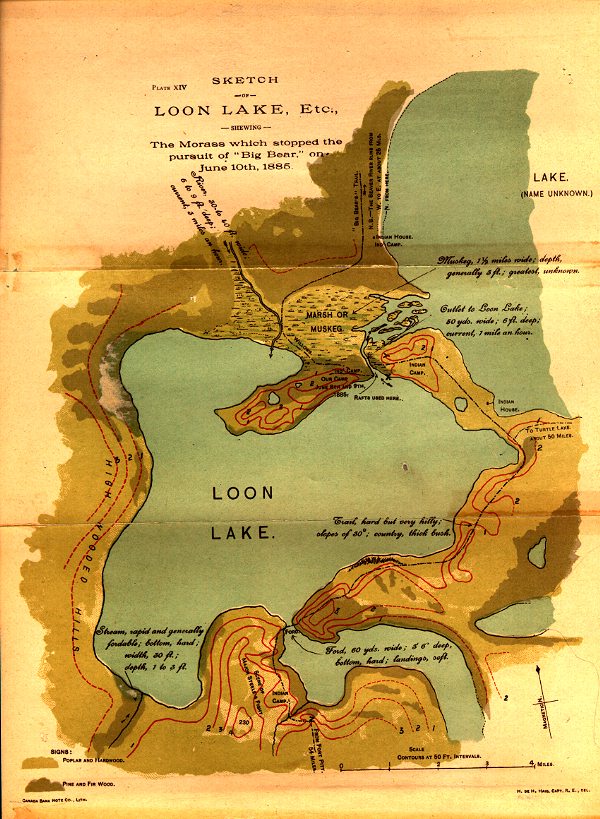
The Battle of Loon Lake, also known as the Battle of Steele Narrows, concluded the North-West Rebellion on June 3, 1885, and was the last battle fought on Canadian soil. It was fought in what was then the District of Saskatchewan of the North-West Territories,[2] at what is now known as Steele Narrows at Makwa Lake, in Saskatchewan's Steele Narrows Provincial Park.[3] Steele Narrows[4] is a channel that separates Sanderson Bay from Makwa Lake.
Led by Major Sam Steele, a force of North-West Mounted Police, Alberta Mounted Rifles and Steele's Scouts (a body of mounted militia raised by Steele himself) caught up with and dispersed a band of Plains Cree warriors and their white and Métis hostages.
Cree scouts made a determined stand with what was left of their ammunition, but the body of the Cree column, realizing the hopelessness of their situation, released their prisoners and fled. The Cree casualties were four dead and dozens wounded.[5]
Wandering Spirit, the war chief leading the Cree military campaign, surrendered to authorities at Fort Pitt. Big Bear, the aging peacetime chief of this band of Cree, eluded capture until July 2.
Maps[edit]
- Military map of Loon Lake
- Military map of Loon Lake Ford
- Military map of Loon Lake Island and Muskeg
Legacy[edit]
The site of the battle was designated as a National Historic Site of Canada in 1950.[6]
In the spring of 2008, Tourism, Parks, Culture and Sport Minister Christine Tell proclaimed in Duck Lake, that "the 125th commemoration, in 2010, of the 1885 Northwest Resistance is an excellent opportunity to tell the story of the prairie Métis and First Nations peoples' struggle with Government forces and how it has shaped Canada today."[7] The Battle of Loon Lake is commemorated today by interpretive signs placed by the Government of Saskatchewan and a plaque placed by the Historic Sites and Monuments Board of Canada.[8]
The area of the battlefield was designated a provincial park in 1986. Steele Narrows Provincial Historic Park is an 88 ha (220 acres) park that conserves the lookout point of a Cree burial ground, has interpretive plaques, and a recreation area.[9][10]
See also[edit]
References[edit]
- ^ William Bleasdell Cameron (1888), The war trail of Big Bear (p.207), Toronto: Ryerson Press (published 1926)
- ^ "Canadian Plains Research Center Mapping Division" (PDF). Retrieved September 13, 2013.
- ^ "Steele Narrows Provincial Park". Tourism Saskatchewan. Government of Saskatchewan. Retrieved September 18, 2022.
- ^ "Steele Narrows". Canadian Geographical Names Database. Government of Canada. Retrieved September 17, 2022.
- ^ "The Canadian Encyclopedia (Steele Narrows Battle)". Archived from the original on November 18, 2013. Retrieved November 18, 2013.
- ^ "Steele Narrows Provincial Park". Canada's Historic Places. Parks Canada. Retrieved September 18, 2022.
- ^ "Tourism agencies to celebrate the 125th anniversary of the Northwest Resistance/Rebellion". Home/About Government/News Releases/June 2008. Government of Saskatchewan. June 7, 2008. Archived from the original on October 21, 2009. Retrieved September 20, 2009.
- ^ "Steele Narrows National Historic Site of Canada". Canada's Historic Places. Parks Canada. Retrieved September 18, 2022.
- ^ "Steele Narrows Provincial Park - Tourism, Parks, Culture and Sport -". Brochure of the Northwest Rebellion. Government of Saskatchewan. Archived from the original (pdf) on June 27, 2009. Retrieved September 20, 2009.
- ^ "Makwa". Sasl Biz community profiles. Enterprise Saskatchewan Government of Saskatchewan. Archived from the original on April 23, 2008. Retrieved September 20, 2009.
54°2′26″N 109°18′34″W / 54.04056°N 109.30944°W
| Modern Governments | |
|---|---|
| Historic Governments |
|
| Organizations | |
| History |
|
| Society | |
| Culture | |
National Historic Sites of Canada by location | |
|---|---|
| Provinces | |
| Territories | |
| Other countries | |
This article about a battle is a stub. You can help Wikipedia by expanding it. |
This Canadian history article is a stub. You can help Wikipedia by expanding it. |