
 French
 Deutsch
Araguaia River
| Araguaia River | |
|---|---|
 A tree in the Araguaia National Park in flood season | |
 Map of the Araguaia/Tocantins Watershed | |
| Native name | Rio Araguaia (Portuguese) |
| Location | |
| Country | Brazil |
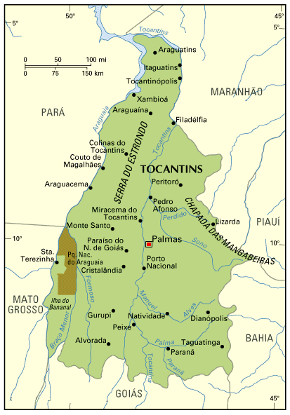
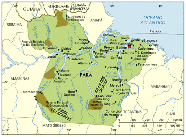
| State | Goiás, Mato Grosso, Tocantins, Pará |
| Cities | Aragarças, Barra do Garças |
| Physical characteristics | |
| Source | Araguaia River |
| • location | Mineiros, Goiás |
| • coordinates | 18°02′02″S 53°03′47″W / 18.034°S 53.063°W |
| • elevation | 858 m (2,815 ft) |
| Mouth | Tocantins River |
• location | São João do Araguaia, Pará |
• coordinates | 5°22′34″S 48°43′08″W / 5.37611°S 48.71889°W |
• elevation | 90 m (300 ft) |
| Length | 2,627 km (1,632 mi) |
| Basin size | 377,000 km2 (146,000 sq mi)[2] 358,125 km2 (138,273 sq mi) |
| Discharge | |
| • location | Conceição do Araguaia, Brazil (Basin size: 358,125 km2 (138,273 sq mi)) |
| • average | 6,172 m3/s (218,000 cu ft/s) 6,216 m3/s (219,500 cu ft/s) |
| Discharge | |
| • location | Confluence of Tocantins |
| • average | 6,420 m3/s (227,000 cu ft/s)[2] 6,500 m3/s (230,000 cu ft/s) |
| Basin features | |
| River system | Tocantins basin |
The Araguaia River (Portuguese: Rio Araguaia [ˈʁi.u aɾaˈɡwajjɐ], Karajá: ♂ Berohokỹ [beɾohoˈkə̃], ♀ Bèrakuhukỹ [bɛɾakuhuˈkə̃])[1] is one of the major rivers of Brazil, and a tributary of the Tocantins River.
Geography[edit]
The Araguaia River comes from Goiás-Mato Grosso south borders. From there it flows northeast to a junction with the Tocantins near the town of São João.[3]
Along its course, the river forms the border between the states of Goiás, Mato Grosso, Tocantins and Pará. Roughly in the middle of its course the Araguaia splits into two forks (with the western one retaining the name Araguaia and the eastern one being called the Javaés River). These later reunite, forming the Ilha do Bananal, the world's largest river island.[3] The vein of the Javaés forms a broad inland where it pours back into the main Araguaia, a 100,000 hectare expanse of igapós or flooded forest, blackwater river channels, and oxbow lakes called Cantão, protected by the Cantão State Park. It is one of the biologically richest areas of the eastern Amazon, with over 700 species of birds, nearly 300 species of fish, large populations of species such as the giant otter, the black caiman, the pirarucú, one of the world's largest freshwater fish, and the Araguaian river dolphin (or Araguaian boto), all occurring within a large area.
A large portion of the Araguaia's course is navigable all year, but the river below the Cantão wetlands is interrupted by rapids.
The middle and lower basin of the river is in the Xingu–Tocantins–Araguaia moist forests ecoregion.[4] The combined watershed of Araguaia and Tocantins rivers (named the Araguaia Tocantins Basin) covers approximately 9.5% of Brazil's national territory. This area is an integral part of the Amazon biome; however, the Araguaia River is not a tributary of the Amazon.
"Araguaia" means "River of the macaws" in the native Tupi language.
Tributaries[edit]

Its principal tributary is the Rio das Mortes, which rises in the Serra de São Jerônimo, near Cuiabá, Mato Grosso, and is navigable to Pará. Other important tributaries include the Bonito, Garcas, Tapirape and the Formoso or Cristalino on the west, and the Pitombas, Claro, Vermelho, Tucupa and Chavante on the east.[5]
History[edit]
This section needs expansion. You can help by adding to it. (November 2011) |
It was explored in part by Henri Coudreau in 1897.[6] From 1972 to 1974 this region was the scene of a conflict between left-wing guerrilla movements and forces supporting the then military dictatorship.
Towns[edit]
Among the most important settlements on the banks of the Araguaia River are (in a downstream order):
- Barra do Garças
- Aragarças
- Aruanã
- Luiz Alves
- São Félix do Araguaia
- Santa Terezinha
- Araguacema
- Conceição do Araguaia
- Xambioá
- São Geraldo do Araguaia
- São João do Araguaia
Tourism[edit]
This section needs expansion. You can help by adding to it. (November 2011) |
Several parts of the river's course are protected by national parks and other reserves like the Emas National Park and the Araguaia National Park. The Araguaia has "beaches" - bright sandy banks that seam the stream from May to October.
Deforestation and Impacts on the Araguaia[edit]
Deforestation and expansion of cattle ranching and agriculture in the Araguaia basin has been extreme during the last four decades.[7][non-primary source needed] As a consequence, strong linear erosion has produced thousand of gullies just in the upper Araguaia basin, and the river mainstem suffered strong sedimentation and fluvial metamorphism (changes in its channel pattern).[8][non-primary source needed]
See also[edit]
References[edit]
- ^ a b Lima, Nei Clara de; Leitão, Rosani Moreira (2019). Iny tkylysinamy rybèna. Arte Iny Karajá: patrimônio cultural do Brasil (PDF). Goiânia: IPHAN-GO. ISBN 978-85-7334-343-4.
- ^ a b Aquino, Samia; Latrubesse, Edgardo; Bayer, Maximiliano (2009). "Assessment of wash load transport in the Araguaia River (Aruanã Gauge Station), central Brazil". Latin American Journal of Sedimentology and Basin Analysis. 16 (2): 119–128.
- ^ a b "Araguaia River". Encyclopædia Britannica. Encyclopædia Britannica Inc. 2015. Retrieved 2015-02-13.
- ^ Sears, Robin, Eastern Amazonian - Brazil (NT0180), WWF: World Wildlife Fund, retrieved 2017-03-22
- ^ One or more of the preceding sentences incorporates text from a publication now in the public domain: Chisholm, Hugh, ed. (1911). "Araguaya". Encyclopædia Britannica. Vol. 2 (11th ed.). Cambridge University Press. p. 315.
- ^ Coudreau's Voyage au Tocantins-Araguaya (Paris, 1897)
- ^ Ferreira, Manuel E.; Ferreira, Laerte G.; Latrubesse, Edgardo M.; Miziara, Fausto (2013-10-10). "Considerations about the land use and conversion trends in the savanna environments of Central Brazil under a geomorphological perspective". Journal of Land Use Science. 11 (1). Informa UK Limited: 33–47. doi:10.1080/1747423x.2013.845613. ISSN 1747-423X. S2CID 128533975.
- ^ Latrubesse, Edgardo (2009). "The Geomorphologic response of a large pristine alluvial river to tremendous deforestation in the South American Tropics: The case of the Araguaia River". Geomorphology. 113 (3–4): 239–252. Bibcode:2009Geomo.113..239L. doi:10.1016/j.geomorph.2009.03.014. hdl:11336/102246.
External links[edit]
- Rio Araguaia (information for tourists in Portuguese, Spanish and English)
- Hotel, turismo, pescaria, passeios ecológicos Araguaia,Luiz Alves, Bananal, Cristalino
- hydrographic information (in Portuguese)
- Basin map (in Portuguese)
- Tocantins state, with Rivers v-Brazil.com
- Pará state, with Rivers v-Brazil.com
- Instituto Araguaia
- Brazilian Ministry of Transport
| International | |
|---|---|
| National | |