
 French
 Deutsch
File:Irene Aug 24 2011 1810Z.jpg - 维基百科,自由的百科全书

原始文件 (6,400 × 8,200像素,文件大小:25.48 MB,MIME类型:image/jpeg)
| 警告 | 部分浏览器在浏览此图片的完整大小时可能会遇到困难:该图片中有数量巨大的像素点,可能无法完全载入或者导致您的浏览器停止响应。 |
|---|
摘要
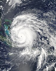
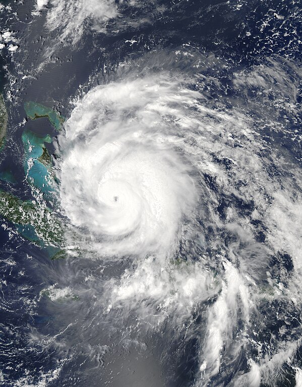
| 描述 | English: Hurricane Irene strengthened on its path toward the continental United States in late August 2011. Residents of the U.S. East Coast braced for the first hurricane to seriously threaten the country in three years, Voice of America reported. The Moderate Resolution Imaging Spectroradiometer (MODIS) on NASA’s Aqua satellite captured this natural-color image at 2:15 p.m. local time (18:15 UTC) on August 24. Storm clouds hide the Turks and Caicos Islands, and extend westward over The Bahamas. Clouds also linger over the Dominican Republic and Haiti. At 2:00 p.m. Eastern Daylight Time on August 24, about the time MODIS took this picture, the U.S. National Hurricane Center (NHC) reported that Irene was a Category 3 hurricane with maximum sustained winds of 120 miles (195 kilometers) per hour. By 5:00 a.m. EDT on August 25, the NHC reported, Irene’s winds had weakened slightly, to 115 miles (185 kilometers) per hour. The storm remained a powerful Category 3 hurricane. A hurricane warning was in effect for the southeastern, central, and northwestern Bahamas. A hurricane watch was in effect for Surf City, North Carolina, northward to the Virginia border. A tropical storm watch was in effect for Edisto Beach, South Carolina, north to Surf City. As of 5:00 a.m. EDT on August 25, Irene was moving toward the northwest at about 12 miles (19 kilometers) per hour. The storm was expected to turn toward the north-northwest the same day, then toward the north early the following day. The NHC five-day storm track showed Irene moving northward along the U.S. East Coast. As U.S. residents braced for Irene’s arrival, residents of Caribbean Islands cleaned up from the destructive storm. The Christian Science Monitor reported that flooding and mudslides had forced the Dominican Republic to evacuate nearly 38,000 people, and a U.S.-based analysis firm estimated potential damage in the Caribbean at up to $3.1 billion. |
| 日期 | |
| 来源 | http://earthobservatory.nasa.gov/NaturalHazards/view.php?id=51867 |
| 作者 | NASA image courtesy Jeff Schmaltz, MODIS Rapid Response, NASA Goddard Space Flight Center. Caption by Michon Scott. |
许可协议
| 本文件完全由NASA创作,在美国属于公有领域。根据NASA的版权方针,NASA的材料除非另有声明否则不受版权保护。(参见Template:PD-USGov/zh、NASA版权方针页面或JPL图片使用方针。) | ||
 | 警告:
|
文件历史
点击某个日期/时间查看对应时刻的文件。
| 日期/时间 | 缩略图 | 大小 | 用户 | 备注 | |
|---|---|---|---|---|---|
| 当前 | 2019年10月29日 (二) 06:49 | | 6,400 × 8,200(25.48 MB) | Nino Marakot | Reverted to version as of 22:50, 29 July 2013 (UTC) - Reverting to final re-upload by Supportstorm |
| 2018年4月15日 (日) 23:26 |  | 8,232 × 9,737(55.25 MB) | MarioProtIV | Reverted to version as of 02:33, 14 November 2012 (UTC) | |
| 2018年3月29日 (四) 23:07 |  | 1,400 × 1,700(402 KB) | CooperScience | Centering image | |
| 2013年7月29日 (一) 22:50 |  | 6,400 × 8,200(25.48 MB) | Supportstorm | Gallery version | |
| 2012年11月14日 (三) 02:33 |  | 8,232 × 9,737(55.25 MB) | Supportstorm | HDF File Quality Image | |
| 2011年8月24日 (三) 21:36 |  | 6,620 × 6,620(6.45 MB) | Supportstorm | {{Information |Description ={{en|1=Major Hurricane Irene on August 24, 2011 as a category three.}} |Source =http://lance-modis.eosdis.nasa.gov/wms/?zoom=3&lat=21.75&lon=-16.18359&layers=000B0FFFFFFT&datum1=08/24/2011 |Author =NASA, MODI |
文件用途
以下2个页面使用本文件:
全域文件用途
以下其他wiki使用此文件:
- ar.wikipedia.org上的用途
- de.wikipedia.org上的用途
- en.wikipedia.org上的用途
- eo.wikipedia.org上的用途
- es.wikipedia.org上的用途
- es.wikinews.org上的用途
- eu.wikipedia.org上的用途
- fa.wikipedia.org上的用途
- fi.wikipedia.org上的用途
- fr.wikipedia.org上的用途
- hi.wikipedia.org上的用途
- id.wikipedia.org上的用途
- is.wikipedia.org上的用途
- it.wikipedia.org上的用途
- ja.wikipedia.org上的用途
- jv.wikipedia.org上的用途
- ko.wikipedia.org上的用途
- ms.wikipedia.org上的用途
- nl.wikipedia.org上的用途
- pl.wikipedia.org上的用途
- pt.wikipedia.org上的用途
- ro.wikipedia.org上的用途
- ru.wikipedia.org上的用途
- ru.wikinews.org上的用途
- simple.wikipedia.org上的用途
- ta.wikipedia.org上的用途
- th.wikipedia.org上的用途
- uk.wikipedia.org上的用途
- vi.wikipedia.org上的用途
- www.wikidata.org上的用途