
 French
 Deutsch
File:1780 Raynal and Bonne Map of Southeast Asia and the Philippines - Geographicus - Philippines-bonne-1780.jpg - 维基百科,自由的百科全书
本预览的尺寸:800 × 554像素。 其他分辨率:320 × 222像素 | 640 × 443像素 | 1,024 × 709像素 | 1,280 × 886像素 | 2,500 × 1,731像素。
原始文件 (2,500 × 1,731像素,文件大小:1.35 MB,MIME类型:image/jpeg)
| Rigobert Bonne:Les Isles Philippines ( | |||||||||||||||||||||||
|---|---|---|---|---|---|---|---|---|---|---|---|---|---|---|---|---|---|---|---|---|---|---|---|
| 艺术家 |
| ||||||||||||||||||||||
| 标题 | Les Isles Philippines | ||||||||||||||||||||||
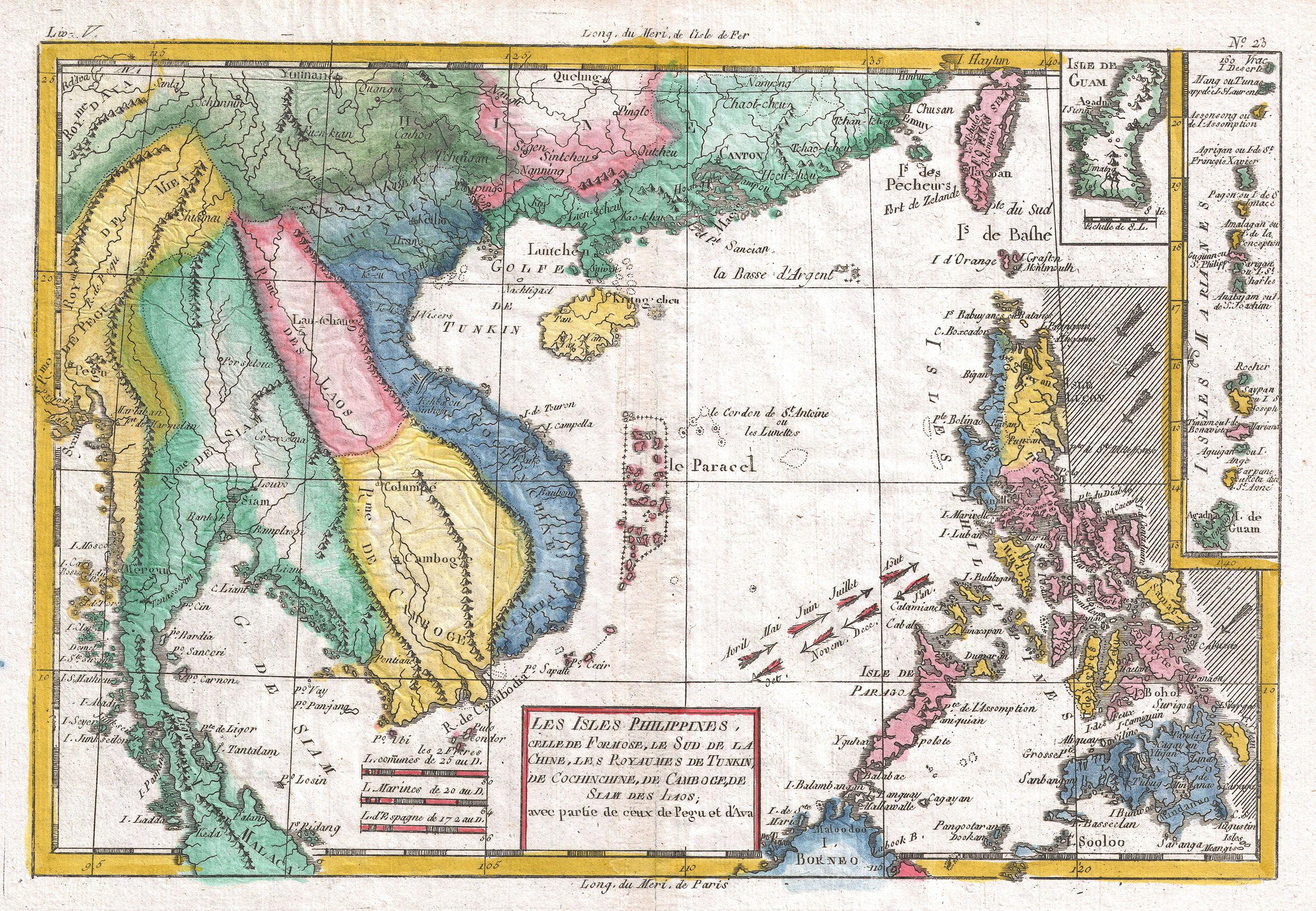
| 描述 | English: A fine example of Rigobert Bonne and G. Raynal’s 1780 map of the Southeast Asia and the Philippines. Map corresponds to modern day countries of the Philippines, Vietnam (Tonquin and Chochin), Cambodia (Camboge), Thailand (Siam), Malaysia (Malaca), Taiwan (Formosa) and Laos. Identifies the cities of Tayoun (Taiwan), Manila, Macao, Siam and Bangkok. Furthermore, the Trịnh lords, Nguyễn lords, the Principality of Hà Tiên, Burma, Guam, Northern Mariana Islands, Hainan, Myanmar, Paracel Islands, Yunnan, Guangxi, Guangdong, North Borneo, Yunnan in Qing dynasty, Tonkin and Cochinchina might be identified via the map. Wind currents and some undersea dangers in the South China Sea. Drawn by R. Bonne for G. Raynal’s Atlas de Toutes les Parties Connues du Globe Terrestre, Dressé pour l'Histoire Philosophique et Politique des Établissemens et du Commerce des Européens dans les Deux Indes . | ||||||||||||||||||||||
| 日期 | 1780年 (undated) | ||||||||||||||||||||||
| 尺寸 | 高度:9英寸(22.8厘米);宽度:13英寸(33厘米) | ||||||||||||||||||||||
| 登录号 | Geographicus link: Philippines-bonne-1780 | ||||||||||||||||||||||
| 来源/摄影师 | Raynal, G., Atlas de Toutes les Parties Connues du Globe Terrestre, Dressé pour l'Histoire Philosophique et Politique des Établissemens et du Commerce des Européens dans les Deux Indes, 1780.
| ||||||||||||||||||||||
| 授权 (二次使用本文件) |
| ||||||||||||||||||||||
文件历史
点击某个日期/时间查看对应时刻的文件。
| 日期/时间 | 缩略图 | 大小 | 用户 | 备注 | |
|---|---|---|---|---|---|
| 当前 | 2011年3月24日 (四) 09:06 | | 2,500 × 1,731(1.35 MB) | BotMultichillT | {{subst:User:Multichill/Geographicus |link=http://www.geographicus.com/P/AntiqueMap/Philippines-bonne-1780 |product_name=1780 Raynal and Bonne Map of Southeast Asia and the Philippines |map_title=Les Isles Philippines |description=A fine example of Rigobe |
文件用途
以下页面使用本文件:
全域文件用途
以下其他wiki使用此文件:
- en.wikipedia.org上的用途
- fr.wikipedia.org上的用途
- vi.wikipedia.org上的用途