
 French
 Deutsch
Файл:Venusvulkan Tick-Typ.jpg — Вікіпедія

Повна роздільність (1637 × 1433 пікселів, розмір файлу: 770 КБ, MIME-тип: image/jpeg)
| Відомості про цей файл містяться на Вікісховищі — централізованому сховищі вільних файлів мультимедіа для використання у проектах Фонду Вікімедіа. |
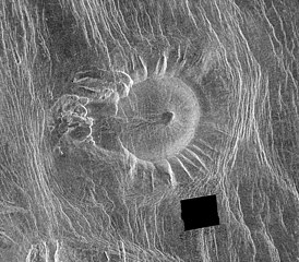
| Опис | This Magellan image is of an area located in the Eistla Region [Error: This is in the Alpha Regio[1]] of Venus in the southern hemisphere and is centered at 5.5 degrees east longitude, 18 degrees south latitude. It is 122 kilometers (76 miles) across east to west and 107 kilometers (66 miles) north to south. North is at the top of the image. Shown is an unusual volcanic edifice unlike all others previously observed. It is approximately 66 kilometers (41 miles) across at the base and has a relatively flat, slightly concave summit 35 kilometers (22 miles) in diameter. The sides of the edifice are characterized by radiating ridges and valleys that impart a fluted appearance. To the west, the rim of the structure appears to have been breached by dark lava flows that emanated from a shallow summit pit approximately 5 kilometers (3 miles) in diameter and traveled west along a channel approximately 5 kilometers wide and 27 kilometers (17 miles) long. A series of coalescing, collapsed pits 2 to 10 kilometers (1.2 to 6.2 miles) in diameter are located 10 kilometers (6 miles) west of the summit. The edifice and western pits are circumscribed by faint, concentric lineaments up to 70 kilometers (43 miles) in diameter. A series of north northwest trending graben are deflected eastward around the edifice; the interplay of these graben and the fluted rim of the edifice produce a distinctive scalloped pattern in the image. Several north northwest trending lineaments cut directly across the summit region. This peculiar volcanic construct is located 25 to 30 kilometers (15 to 19 miles) north of Alpha Regio, a highly deformed region of tessera terrain. A collection of at least six similar volcanoes has been observed near Thetis Regio, a region of tessera within Aphrodite Terra. Thus, these unusual constructs tentatively appear to be spatially associated with regions of tessera. A tessera is a complex, deformed terrain on Venus consisting of at least two sets of intersecting ridges and troughs. The implications of this spatial association on the unusual morphology of these constructs are being investigated. The feature is unnamed as for 2016 (a map of the region) |
| Час створення | image published 29. Jan. 1996 |
| Джерело | NASA planetary photojournal |
| Автор | NASA/JPL |
| Ліцензія (Повторне використання цього файлу) | Copyright information from http://www.jpl.nasa.gov/images/policy/index.cfm - Unless otherwise noted, images and video on JPL public web sites (public sites ending with a jpl.nasa.gov address) may be used for any purpose without prior permission [...] |
Це зображення або відео внесене у каталог одного з центрів Національного управління з аеронавтики і дослідження космічного простору США (NASA)під фото ID: PIA00089. Це не тег авторських прав. Дійсна ліцензія має додаватись до цього тегу. Інші мови:
|
| Цей файл перебуває у суспільному надбанні, оскільки він був створений NASA (Національним управлінням з аеронавтики і дослідження космічного простору). Згідно з політикою NASA стосовно авторського права, «матеріали NASA не захищаються авторським правом, якщо не вказано протилежне». (Див. Template:PD-USGov, сторінку політики NASA стосовно авторського права, або політику використання зображень JPL.) | ||
 | Попередження:
|
Історія файлу
Клацніть на дату/час, щоб переглянути, як тоді виглядав файл.
| Дата/час | Мініатюра | Розмір об'єкта | Користувач | Коментар | |
|---|---|---|---|---|---|
| поточний | 22:19, 12 лютого 2006 | | 1637 × 1433 (770 КБ) | Arnomane | higher resolution |
| 17:01, 2 вересня 2005 |  | 1068 × 935 (285 КБ) | Lotse | *'''Original Caption Released with Image:''' This Magellan image is of an area located in the Eistla Region of Venus in the southern hemisphere and is centered at 5.5 degrees east longitude, 18 degrees south latitude. It is 122 kilometers (76 miles) acros |
Використання файлу
Такі сторінки використовують цей файл:
Глобальне використання файлу
Цей файл використовують такі інші вікі:
- Використання в ar.wikipedia.org
- Використання в de.wikipedia.org
- Використання в en.wikipedia.org
- Використання в eu.wikipedia.org
- Використання в he.wikipedia.org
- Використання в hu.wikipedia.org
- Використання в id.wikipedia.org
- Використання в nl.wikipedia.org
- Використання в ro.wikipedia.org
- Використання в ru.wikipedia.org
- Використання в sr.wikipedia.org
- Використання в zh.wikipedia.org