
 French
 Deutsch
Sheridan County, Kansas - Simple English Wikipedia, the free encyclopedia
Sheridan County | |
|---|---|
.jpg) Buffalo Hunters' Home in Sheridan (1873) | |
 Location within the U.S. state of Kansas | |
 Kansas's location within the U.S. | |
| Coordinates: 39°21′N 100°26′W / 39.35°N 100.43°W | |
| Country | |
| State | |
| Founded | 1873 |
| Named for | Philip Sheridan |
| Seat | Hoxie |
| Largest city | Hoxie |
| Area | |
| • Total | 896 sq mi (2,320 km2) |
| • Land | 896 sq mi (2,320 km2) |
| • Water | 0.3 sq mi (0.8 km2) 0.03% |
| Population | |
| • Total | 2,447 |
| • Density | 2.7/sq mi (1.0/km2) |
| Time zone | UTC−6 (Central) |
| • Summer (DST) | UTC−5 (CDT) |
| Congressional district | 1st |
| Website | County Website |

Sheridan County (standard abbreviation: SD) is a county in the U.S. state of Kansas. In 2020, 2,447 people lived there.[1] Its county seat is Hoxie.[2] The county was named after Phillip H. Sheridan, a general of the American Civil War era.
History[change | change source]
19th century[change | change source]
In 1873, the rest of the unorganized part of the state was divided into 22 new counties. This included Sheridan County.[3] Sheridan County was then organized in 1880. The county seat was in Kenneth.[4]
20th century[change | change source]
The railroad was still used in Sheridan County until 1998. After flooding east of Plainville in the 1993 floods damaged the railroad, the railroad decided not to rebuild. The entire railroad from Plainville to Colby was abandoned by 1998.[5][6]
Geography[change | change source]
The U.S. Census Bureau says that the county has a total area of 896 square miles (2,320 km2). Of that, 896 square miles (2,320 km2) is land and 0.3 square miles (0.78 km2) (0.03%) is water.[7]
People[change | change source]
| Historical population | |||
|---|---|---|---|
| Census | Pop. | %± | |
| 1880 | 1,567 | — | |
| 1890 | 3,733 | 138.2% | |
| 1900 | 3,819 | 2.3% | |
| 1910 | 5,651 | 48.0% | |
| 1920 | 5,484 | −3.0% | |
| 1930 | 6,038 | 10.1% | |
| 1940 | 5,312 | −12.0% | |
| 1950 | 4,607 | −13.3% | |
| 1960 | 4,267 | −7.4% | |
| 1970 | 3,859 | −9.6% | |
| 1980 | 3,544 | −8.2% | |
| 1990 | 3,043 | −14.1% | |
| 2000 | 2,813 | −7.6% | |
| 2010 | 2,556 | −9.1% | |
| 2020 | 2,447 | −4.3% | |
| U.S. Decennial Census[8] 1790-1960[9] 1900-1990[10] 1990-2000[11] 2010-2020[1] | |||

Government[change | change source]
Presidential elections[change | change source]
| Year | Republican | Democratic | Third Parties |
|---|---|---|---|
| 2020 | 88.7% 1,282 | 10.2% 147 | 1.1% 16 |
| 2016 | 87.1% 1,197 | 9.2% 127 | 3.6% 50 |
| 2012 | 86.0% 1,154 | 12.5% 168 | 1.5% 20 |
| 2008 | 80.5% 1,108 | 18.5% 254 | 1.0% 14 |
| 2004 | 81.4% 1,144 | 17.0% 239 | 1.6% 23 |
| 2000 | 76.0% 1,132 | 18.9% 281 | 5.1% 76 |
| 1996 | 74.2% 1,053 | 18.6% 264 | 7.3% 103 |
| 1992 | 45.2% 739 | 21.2% 347 | 33.6% 550 |
| 1988 | 57.9% 901 | 38.6% 600 | 3.5% 55 |
| 1984 | 73.9% 1,274 | 24.3% 419 | 1.9% 32 |
| 1980 | 71.0% 1,202 | 23.1% 391 | 5.9% 100 |
| 1976 | 49.2% 838 | 46.5% 793 | 4.3% 74 |
| 1972 | 64.4% 1,134 | 31.4% 552 | 4.3% 75 |
| 1968 | 58.4% 1,002 | 32.8% 563 | 8.9% 152 |
| 1964 | 43.8% 808 | 55.7% 1,028 | 0.6% 11 |
| 1960 | 51.9% 1,047 | 47.3% 954 | 0.7% 15 |
| 1956 | 67.4% 1,324 | 32.2% 633 | 0.4% 7 |
| 1952 | 73.9% 1,581 | 25.9% 555 | 0.2% 4 |
| 1948 | 52.7% 1,097 | 46.4% 966 | 0.9% 19 |
| 1944 | 66.9% 1,342 | 32.8% 658 | 0.4% 7 |
| 1940 | 62.1% 1,492 | 37.6% 903 | 0.4% 9 |
| 1936 | 40.3% 1,007 | 57.7% 1,442 | 2.1% 52 |
| 1932 | 32.4% 878 | 65.5% 1,773 | 2.1% 56 |
| 1928 | 60.5% 1,450 | 38.8% 930 | 0.7% 16 |
| 1924 | 59.1% 1,320 | 24.3% 542 | 16.6% 371 |
| 1920 | 69.5% 1,194 | 27.8% 477 | 2.7% 46 |
| 1916 | 37.5% 760 | 58.7% 1,189 | 3.8% 78 |
| 1912 | 18.2% 195 | 47.5% 509 | 34.3% 368 |
| 1908 | 48.9% 639 | 48.3% 631 | 2.8% 37 |
| 1904 | 57.9% 607 | 28.0% 293 | 14.1% 148 |
| 1900 | 46.3% 445 | 51.9% 499 | 1.8% 17 |
| 1896 | 40.5% 282 | 55.1% 384 | 4.5% 31 |
| 1892 | 41.1% 325 | 58.9% 466 | |
| 1888 | 62.0% 623 | 33.5% 337 | 4.5% 45 |
Sheridan County is very Republican.
Education[change | change source]
Unified school districts[change | change source]
Communities[change | change source]

Cities[change | change source]
References[change | change source]
- ↑ 1.0 1.1 1.2 "QuickFacts: Sheridan County, Kansas". United States Census Bureau. Retrieved October 3, 2023.
- ↑ "Find a County". National Association of Counties. Retrieved 2011-06-07.
- ↑ Transactions of the Kansas State Historical Society, 1903-1904 (1904)
- ↑ Cutler, William G. History of the State of Kansas (1883)
- ↑ Surfact Transportation Board Decision, Docket No. AB-33, March 21, 1997 Archived October 30, 2019, at the Wayback Machine, STB.gov, Retrieved 23 October 2017
- ↑ The Plainville Branch, Abandonedrails.com, Retrieved 23 October 2017
- ↑ "US Gazetteer files: 2010, 2000, and 1990". United States Census Bureau. 2011-02-12. Retrieved 2011-04-23.
- ↑ "U.S. Decennial Census". United States Census Bureau. Retrieved July 29, 2014.
- ↑ "Historical Census Browser". University of Virginia Library. Archived from the original on August 11, 2012. Retrieved July 29, 2014.
- ↑ "Population of Counties by Decennial Census: 1900 to 1990". United States Census Bureau. Retrieved July 29, 2014.
- ↑ "Census 2000 PHC-T-4. Ranking Tables for Counties: 1990 and 2000" (PDF). United States Census Bureau. Retrieved July 29, 2014.
- ↑ "Dave Leip's Atlas of U.S. Presidential Elections".
More reading[change | change source]
- Standard Atlas of Sheridan County, Kansas; Geo. A. Ogle & Co; 58 pages; 1907.
Other websites[change | change source]
- County
- Other
- Maps
- Sheridan County Maps: Current, Historic, KDOT
- Kansas Highway Maps: Current, Historic, KDOT
- Kansas Railroad Maps: Current, 1996, 1915, KDOT and Kansas Historical Society
Municipalities and communities of Sheridan County, Kansas, United States | ||
|---|---|---|
| Cities | 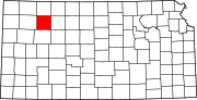 | |
| Unincorporated communities | ||
| Ghost towns | ||
| Townships | ||

39°21′N 100°26′W / 39.350°N 100.433°W
| International | |
|---|---|
| National | |