Rhineland-Palatinate - Simple English Wikipedia, the free encyclopedia
Rhineland-Palatinate Rheinland-Pfalz | |
|---|---|
 Position of the Rhineland-Palatinate within Germany | |
| Country | Germany |
| Capital | Mainz |
| Government | |
| • Minister President | Malu Dreyer (SPD) |
| • Governing parties | SPD / FDP / Greens |
| Area | |
| • Total | 19,847.21 km2 (7,663.05 sq mi) |
| Population (31 December 2016) | |
| • Total | 4,073,280 |
| • Density | 210/km2 (530/sq mi) |
| Time zone | UTC+1 (CET) |
| • Summer (DST) | UTC+2 (CEST) |
| Website | rlp.de |
Rhineland-Palatinate (German: Rheinland-Pfalz, Rhine Franconian: Rhoilond-Palz) is one of 16 states (German: Bundesländer) of Germany. It has an area of 19,847 km2 (7,663.0 sq mi) and 4.073 million people living in it. The capital is Mainz.
History[change | change source]
Rhineland-Palatinate was created on 30 August 1947. It was formed from the northern part of the French Occupation Zone (the Rhenish Palatinate or German: pfalz which had been a part of Bavaria) as well as the southern parts of the Prussian Rhine Province, Birkenfeld which formerly belonged to Oldenburg, parts of the Prussian Province of Nassau (see Hesse-Nassau), and parts of Hesse-Darmstadt as well as Rheinhessen on the western banks of the Rhine.
The people of the new state voted to accept the boundary changes in a referendum on 18 May 1947.
Geography[change | change source]
Rhineland-Palatinate borders on (from the north and clockwise) North Rhine-Westphalia (another German state), Hesse (another German state), Baden-Württemberg (another German state), France, Saarland (another German state), Luxembourg, and Belgium.
The main axis of the state is the Rhine river, that forms the border with Baden-Württemberg and Hesse in the southeast before running across the northern part of Rhineland-Palatinate. The Rhine Valley is bounded by mountains with some of the historically most significant places of Germany.
In the northwest there are the southern parts of the Eifel mountains. Farther south there is the Hunsrück mountain, which is continued by the Taunus mountains on the opposite side of the Rhine. The hilly lands in the south of the state are called the Palatine Forest (Pfälzerwald).
These mountains are separated from each other by the tributaries of the Rhine: the Moselle (Mosel), the Lahn and the Nahe.
Government[change | change source]
Rhineland-Palatinate is a parliamentary democracy. Every five years, all Germans over the age of 18 elect the members of the Rhineland-Palatinate Parliament, German: Landtag. This regional parliament or legislature then elects the premier and confirms the cabinet members. Rhineland-Palatinate is the only German Bundesland (state) to have a cabinet minister for winegrowing.
Castles[change | change source]
This is only some of the castles in Rhineland-Palatine:


| Name | Place |
|---|---|
| Burg Arras | Alf |
| Alte Burg | Boppard |
| Reichsburg Cochem | Cochem |
| Dahn | Dahn |
| Festung Ehrenbreitstein | Koblenz, Ehrenbreitstein district |
| Ehrenburg | Brodenbach |
| Burg Eltz | Münstermaifeld |
| Burg Falkenstein | Falkenstein |
| Frauenburg | Frauenberg |
| Hambacher Schloss | Neustadt an der Weinstraße, Hambach district |
| Burg Hohenfels | Imsbach |
| Burg und Schloss Idar-Oberstein | Idar-Oberstein |
| Burg Lahneck | Lahnstein |
| Burg Altleiningen | Altleiningen |
| Marksburg | Braubach |
| Burg Nassau | Nassau |
| Nürburg | Nürburg |
| Burg Olbrück | Niederdürenbach |
| Burg Pfalzgrafenstein | on an island in the Rhine, by Kaub |
| Burg Reichenstein | Trechtingshausen |
| Burg Rheinfels | Sankt Goar |
| Rheinstein | Trechtingshausen |
| Schloss und Burg Sayn | Bendorf |
| Schloss Bürresheim | Sankt Johann, Mayen-Koblenz, Bürresheim district |
| Schloss Neuwied | Neuwied |
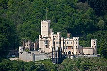
| Schloss Stolzenfels | Koblenz, Stolzenfels district |
| Schmidtburg | Schneppenbach |
| Schönburg | Oberwesel |
| Burg Sooneck | Niederheimbach |
| Burg Stahleck | Bacharach |
| Trifels | Annweiler am Trifels |
| Schloss Montabaur | Montabaur |
| Thurant | Alken |
Universities[change | change source]
There are 7 universities and 13 "Fachhochschulen".
- Technische Universität Kaiserslautern
- Universität Koblenz-Landau – locations: Koblenz, Landau
- Johannes Gutenberg-Universität Mainz
- Universität Trier

- Fachhochschule Bingen
- Fachhochschule Kaiserslautern – locations: Kaiserslautern I and II, Pirmasens and Zweibrücken
- Fachhochschule Koblenz – locations: Koblenz, Höhr-Grenzhausen, Remagen
- Fachhochschule Ludwigshafen
- Evangelische Fachhochschule Ludwigshafen
- Fachhochschule Mainz
- Fachhochschule Trier – locations: Trier, Idar-Oberstein, Birkenfeld
- Fachhochschule Worms
- Katholische Fachhochschule Mainz
- Fachhochschule für Finanzen Edenkoben
- Fachhochschule der Deutschen Bundesbank, Hachenburg
- Fachhochschule für öffentliche Verwaltung Mayen
- Wissenschaftliche Hochschule für Unternehmensführung Otto-Beisheim-Hochschule (private university)
- Philosophisch-Theologische Hochschule Vallendar (church university)
Politics[change | change source]
The Ministers President since 1947:
- 1947–1947: Wilhelm Boden, CDU
- 1947–1969: Peter Altmeier, CDU
- 1969–1976: Helmut Kohl, CDU
- 1976–1988: Bernhard Vogel, CDU
- 1988–1991: Carl-Ludwig Wagner, CDU
- 1991–1994: Rudolf Scharping, SPD
- 1994–2013: Kurt Beck, SPD
- 2013–present: Malu Dreyer, SPD
Partnerships[change | change source]
 France, Bourgogne
 Rwanda, in East Africa
 Spain, Province of València
 Belgium's German-Speaking Community
 Poland, Voivodeship of Oppeln
 Czech Republic, Middle Bohemia
 China, Province of Fujian
 USA, State of South Carolina
 Japan, Prefecture of Iwate
Administration[change | change source]
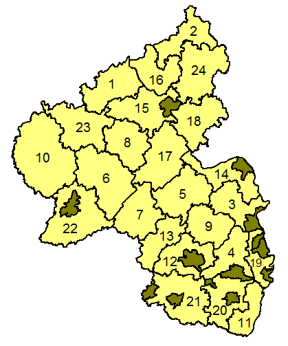
Rhineland-Palatinate is divided into 24 districts, grouped into the three administrative regions: Koblenz, Trier and Rheinhessen-Pfalz.
Districts[change | change source]
(with county code car plate)

|
|


 French
 Deutsch

