Rawlins County, Kansas - Simple English Wikipedia, the free encyclopedia
Rawlins County | |
|---|---|
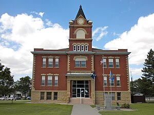
 Rawlins County Courthouse in Atwood (2010) | |
 Location within the U.S. state of Kansas | |
 Kansas's location within the U.S. | |
| Coordinates: 39°48′N 101°06′W / 39.800°N 101.100°W | |
| Country | |
| State | |
| Founded | March 20, 1873 |
| Named for | John Aaron Rawlins |
| Seat | Atwood |
| Largest city | Atwood |
| Area | |
| • Total | 1,070 sq mi (2,800 km2) |
| • Land | 1,069 sq mi (2,770 km2) |
| • Water | 0.2 sq mi (0.5 km2) 0.01% |
| Population | |
| • Total | 2,561 |
| • Density | 2.4/sq mi (0.9/km2) |
| Time zone | UTC−6 (Central) |
| • Summer (DST) | UTC−5 (CDT) |
| Area code | 785 |
| Congressional district | 1st |
| Website | www |
Rawlins County (standard abbreviation: RA) is a county in the U.S. state of Kansas. In 2020, 2,561 people lived there.[1] The county seat is Atwood. Atwood is also the biggest city in Rawlins County.[2] It was named after Union Civil War General John Aaron Rawlins.
History[change | change source]
In 1873, Rawlins County was created.
Geography[change | change source]
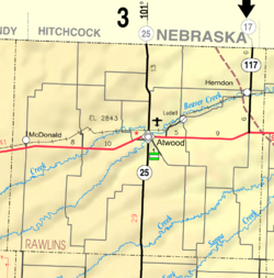
The U.S. Census Bureau says that the county has a total area of 1,070 square miles (2,800 km2). Of that, 1,069 square miles (2,770 km2) is land and 0.2 square miles (0.52 km2) (0.1%) is water.[3]
Major highways[change | change source]
People[change | change source]
| Historical population | |||
|---|---|---|---|
| Census | Pop. | %± | |
| 1880 | 1,623 | — | |
| 1890 | 6,756 | 316.3% | |
| 1900 | 5,241 | −22.4% | |
| 1910 | 6,380 | 21.7% | |
| 1920 | 6,799 | 6.6% | |
| 1930 | 7,362 | 8.3% | |
| 1940 | 6,618 | −10.1% | |
| 1950 | 5,728 | −13.4% | |
| 1960 | 5,279 | −7.8% | |
| 1970 | 4,393 | −16.8% | |
| 1980 | 4,105 | −6.6% | |
| 1990 | 3,404 | −17.1% | |
| 2000 | 2,966 | −12.9% | |
| 2010 | 2,519 | −15.1% | |
| 2020 | 2,561 | 1.7% | |
| U.S. Decennial Census[4] 1790-1960[5] 1900-1990[6] 1990-2000[7] 2010-2020[1] | |||

Government[change | change source]
Presidential elections[change | change source]
| Year | Republican | Democratic | Third Parties |
|---|---|---|---|
| 2020 | 83.8% 1,261 | 14.2% 214 | 1.9% 29 |
| 2016 | 82.9% 1,220 | 11.1% 163 | 6.1% 89 |
| 2012 | 84.7% 1,223 | 13.2% 190 | 2.2% 31 |
| 2008 | 80.5% 1,247 | 17.6% 273 | 1.9% 29 |
| 2004 | 82.2% 1,414 | 16.8% 289 | 1.0% 17 |
| 2000 | 77.5% 1,349 | 17.6% 306 | 4.9% 85 |
| 1996 | 73.8% 1,393 | 17.7% 335 | 8.5% 160 |
| 1992 | 52.9% 1,023 | 20.3% 393 | 26.8% 519 |
| 1988 | 66.5% 1,318 | 30.9% 612 | 2.7% 53 |
| 1984 | 78.1% 1,625 | 19.8% 412 | 2.2% 45 |
| 1980 | 73.4% 1,524 | 20.6% 427 | 6.0% 125 |
| 1976 | 53.9% 1,148 | 42.4% 903 | 3.8% 80 |
| 1972 | 70.5% 1,553 | 25.4% 560 | 4.1% 91 |
| 1968 | 65.9% 1,438 | 25.3% 553 | 8.8% 191 |
| 1964 | 57.1% 1,292 | 42.4% 959 | 0.4% 10 |
| 1960 | 61.7% 1,560 | 37.6% 951 | 0.6% 16 |
| 1956 | 69.9% 1,668 | 29.8% 711 | 0.3% 8 |
| 1952 | 75.8% 2,120 | 24.0% 670 | 0.2% 6 |
| 1948 | 55.1% 1,389 | 43.4% 1,095 | 1.5% 38 |
| 1944 | 61.7% 1,569 | 37.6% 955 | 0.7% 18 |
| 1940 | 58.0% 1,758 | 41.2% 1,247 | 0.8% 25 |
| 1936 | 40.1% 1,364 | 59.6% 2,029 | 0.3% 11 |
| 1932 | 31.1% 1,064 | 65.6% 2,245 | 3.3% 114 |
| 1928 | 57.8% 1,668 | 40.3% 1,164 | 1.9% 55 |
| 1924 | 45.8% 1,213 | 28.0% 742 | 26.2% 694 |
| 1920 | 64.8% 1,236 | 26.0% 495 | 9.2% 176 |
| 1916 | 35.1% 803 | 55.5% 1,271 | 9.5% 217 |
| 1912 | 16.6% 220 | 42.9% 568 | 40.4% 535 |
| 1908 | 47.4% 719 | 48.2% 732 | 4.4% 67 |
| 1904 | 61.1% 749 | 33.1% 405 | 5.8% 71 |
| 1900 | 45.9% 577 | 53.1% 668 | 1.0% 12 |
| 1896 | 41.8% 439 | 57.9% 609 | 0.3% 3 |
| 1892 | 43.8% 592 | 55.9% 756 | 0.3% 4 |
| 1888 | 57.3% 1,023 | 35.5% 633 | 7.2% 129 |
The county is part of the very Republican Kansas's 1st congressional district. It has voted for the Republican candidate for President in each of the last eighteen elections. The last Democrat to win the county was Franklin D. Roosevelt in 1936.[9] In the last five Presidential elections the Democratic candidate has never won more than 21% of the county's vote.[10]
Education[change | change source]
Unified school districts[change | change source]
Communities[change | change source]

Incorporated cities[change | change source]
References[change | change source]
- ↑ 1.0 1.1 1.2 "QuickFacts: Rawlins County, Kansas". United States Census Bureau. Retrieved October 3, 2023.
- ↑ "Find a County". National Association of Counties. Retrieved 2011-06-07.
- ↑ "US Gazetteer files: 2010, 2000, and 1990". United States Census Bureau. 2011-02-12. Retrieved 2011-04-23.
- ↑ "U.S. Decennial Census". United States Census Bureau. Retrieved July 28, 2014.
- ↑ "Historical Census Browser". University of Virginia Library. Archived from the original on August 11, 2012. Retrieved July 28, 2014.
- ↑ "Population of Counties by Decennial Census: 1900 to 1990". United States Census Bureau. Retrieved July 28, 2014.
- ↑ "Census 2000 PHC-T-4. Ranking Tables for Counties: 1990 and 2000" (PDF). United States Census Bureau. Retrieved July 28, 2014.
- ↑ "Dave Leip's Atlas of U.S. Presidential Elections".
- ↑ Geographie Electorale
- ↑ The New York Times electoral map (Zoom in on Kansas)
More reading[change | change source]
- Standard Atlas of Rawlins County, Kansas; Geo. A. Ogle & Co; 64 pages; 1906.
Other websites[change | change source]
- County
- Official website

- Rawlins County - Directory of Public Officials
- Rawlins County - Community Development
- Other
- Rawlins County Square Deal News, newspaper
- Maps
- Rawlins County Maps: Current, Historic, KDOT
- Kansas Highway Maps: Current, Historic, KDOT
- Kansas Railroad Maps: Current, 1996, 1915, KDOT and Kansas Historical Society


 French
 Deutsch
