
 French
 Deutsch
Haute-Garonne - Simple English Wikipedia, the free encyclopedia
Haute-Garonne | |
|---|---|
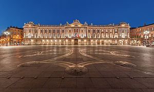
 Prefecture building of the Haute-Garonne department, in Toulouse | |
 Flag  Coat of arms | |
 Location of Haute-Garonne in France | |
| Coordinates: 43°25′N 1°30′E / 43.417°N 1.500°E | |
| Country | France |
| Region | Occitanie |
| Département | 4 March 1790 |
| Prefecture | Toulouse |
| Subprefectures | Saint-Gaudens, Muret |
| Government | |
| • President | Georges Méric[1] |
| Area | |
| • Total | 6,309.3 km2 (2,436.0 sq mi) |
| Population (2014)[3] | |
| • Total | 1,317,668 |
| • Rank | 13th |
| • Density | 210/km2 (540/sq mi) |
| Demonym(s) | Haut-Garonnais, Haut-Garonnaise |
| Time zone | UTC+1 (CET) |
| • Summer (DST) | UTC+2 (CEST) |
| ISO 3166 code | FR-31 |
| Arrondissements | 3 |
| Cantons | 27 |
| Communes | 589 |
| Website | http://www.haute-garonne.fr/ |
Haute-Garonne ("Upper Garonne"; Occitan: Nauta Garona) is a department in the southwest of France named after the Garonne river. Its main city and prefecture of the department is Toulouse.
History[change | change source]
Haute-Garonne is one of the original 83 departments created during the French Revolution on March 4, 1790. It was created from part of the former province of Languedoc.
The department was originally larger than now because it included the district of Castelsarrasin which was transferred to the department of Tarn-et-Garonne when it was created in 1808.[4]
Geography[change | change source]
Haute-Garonne has an area of 6,309.3 km2 (2,436 sq mi).[2] It is part of the Occitanie region. The department is not a historical region of France; this is an administrative division made from various pieces of Languedoc and Gascogne.
The department is surrounded by the departments:
- Ariège to the southeast
- Aude to the east
- Tarn to the northeast
- Tarn-et-Garonne to the north
- Gers to the west
- Hautes-Pyrénées to the southwest
and by Spain (provinces of Lleida and Huesca) to the south.
Places next to Haute-Garonne | ||||||||||
|---|---|---|---|---|---|---|---|---|---|---|
| ||||||||||
The department is crossed by the upper course of the Garonne river (hence the name) for nearly 200 km (120 mi). The borders of the department follow the river. The Garonne enters France from Spain at the town of Fos, goes through Toulouse and leaves the department. Two big canals cross the department from east to west: the Canal du Midi and the Canal de Garonne.
There are three distinct geographical areas in the department:
- The extreme south of the department lies in the Pyrenees mountain range and there are many mountains. The highest mountain is Peak of Perdiguère (42°41′31″N 00°31′07″E / 42.69194°N 0.51861°E) that is 3,221 m (10,568 ft) above sea level.[5]
- A first plain, to the north of the Pyrenees, that extends from Montréjeau to Saint-Martory
- A second plain, the vast plain of Toulouse, that extends from Saint-Martory to the northern border of the department.
Climate[change | change source]
The climate of the department is an oceanic climate with template summers, Cfb in the Köppen climate classification.
| Climate data for Toulouse, Haut-Garonne, France | |||||||||||||
|---|---|---|---|---|---|---|---|---|---|---|---|---|---|
| Month | Jan | Feb | Mar | Apr | May | Jun | Jul | Aug | Sep | Oct | Nov | Dec | Year |
| Average high °C (°F) | 8 (46) | 11 (52) | 13 (55) | 16 (61) | 20 (68) | 25 (77) | 27 (81) | 27 (81) | 24 (75) | 18 (64) | 12 (54) | 9 (48) | 18 (64) |
| Daily mean °C (°F) | 4 (39) | 6 (43) | 8 (46) | 11 (52) | 14 (57) | 18 (64) | 21 (70) | 21 (70) | 18 (64) | 13 (55) | 8 (46) | 5 (41) | 12 (54) |
| Average low °C (°F) | 1 (34) | 2 (36) | 3 (37) | 6 (43) | 9 (48) | 12 (54) | 15 (59) | 15 (59) | 12 (54) | 8 (46) | 5 (41) | 2 (36) | 8 (46) |
| Average rainfall mm (inches) | 40 (1.6) | 40 (1.6) | 50 (2.0) | 60 (2.4) | 70 (2.8) | 60 (2.4) | 30 (1.2) | 50 (2.0) | 50 (2.0) | 50 (2.0) | 60 (2.4) | 50 (2.0) | 610 (24.4) |
| Source: Weatherbase.com [1] | |||||||||||||
Administration[change | change source]
The department is managed by the Departamental Council of the Haute-Garonne in Toulouse. The Haute-Garonne is part of the region of Occitanie.
Administrative divisions[change | change source]
There are 3 arrondissements (districts), 27 cantons and 589 communes (municipalities) in the Haute-Garonne.[6]
| INSEE code | Arrondissement | Capital | Population[7] (2014) | Area[8] (km²) | Density (Inh./km²) | Communes |
|---|---|---|---|---|---|---|
| 311 | Muret | Muret | 215,606 | 1,639.0 | 131.5 | 126 |
| 312 | Saint-Gaudens | Saint-Gaudens | 77,545 | 2,139.6 | 36.2 | 237 |
| 313 | Toulouse | Toulouse | 1,024,517 | 2,530.7 | 404.8 | 226 |
The following is a list of the 27 cantons of the Haute-Garonne department (with their INSEE codes), in France, following the French canton reorganisation which came into effect in March 2015:[9]
- Auterive (3101)
- Bagnères-de-Luchon (3102)
- Blagnac (3103)
- Castanet-Tolosan (3104)
- Castelginest (3105)
- Cazères (3106)
- Escalquens (3107)
- Léguevin (3108)
- Muret (3109)
- Pechbonnieu (3110)
- Plaisance-du-Touch (3111)
- Portet-sur-Garonne (3112)
- Revel (3113)
- Saint-Gaudens (3114)
- Toulouse-1 (3115)
- Toulouse-2 (3116)
- Toulouse-3 (3117)
- Toulouse-4 (3118)
- Toulouse-5 (3119)
- Toulouse-6 (3120)
- Toulouse-7 (3121)
- Toulouse-8 (3122)
- Toulouse-9 (3123)
- Toulouse-10 (3124)
- Toulouse-11 (3125)
- Tournefeuille (3126)
- Villemur-sur-Tarn (3127)
Population[change | change source]
The inhabitants of Haute-Garonne are known, in French, as Haut-Garonnais (women: Haut-Garonnaises).[10]
Haute-Garonne has a population, in 2014, of 1,317,668,[3] for a population density of 208.8 inhabitants/km2. The arrondissement of Toulouse, with 1,024,517 inhabitants, is by far the largest. The other two, Muret and Saint-Gaudens, have respectively 215,606 and 77,545 inhabitants.[7]
Evolution of the population in Haute-Garonne

The 10 cities with more people living in them in 2014 in the department are:

| No. | City | Population[7] (2014) | Arrondissement |
|---|---|---|---|
| 1 | Toulouse | 466,297 | Toulouse |
| 2 | Colomiers | 38,541 | Toulouse |
| 3 | Tournefeuille | 26,674 | Toulouse |
| 4 | Muret | 24,975 | Muret |
| 5 | Blagnac | 23,416 | Toulouse |
| 6 | Plaisance-du-Touch | 17,278 | Toulouse |
| 7 | Cugnaux | 17,004 | Toulouse |
| 8 | Balma | 15,319 | Toulouse |
| 9 | Ramonville-Saint-Agne | 13,986 | Toulouse |
| 10 | Castanet-Tolosan | 12,640 | Toulouse |
Gallery[change | change source]
-
 Capitole de Toulouse at night
 -
 Château de Laréole
 -
 Pyrenees seen from Bagnères-de-Luchon
 -


Related pages[change | change source]
References[change | change source]
- ↑ "Vos conseiller-e-s départementaux" (in French). Haute-Garonne - Departamental Council. Retrieved 12 March 2017.
- ↑ 2.0 2.1 "Département de la Haute-Garonne (31)". Comparateur de territoire (in French). Institut national de la statistique et des études économiques - INSEE. Retrieved 12 March 2017.
- ↑ 3.0 3.1 "Populations légales 2014 des départements et des collectivités d'outre-mer" (in French). Institut national de la statistique et des études économiques - INSEE. Retrieved 13 January 2017.
- ↑ "Création du département de Tarn-et-Garonne". Archives de France. Retrieved 29 September 2013.
- ↑ "Perdiguero, France/Spain". Peakbagger.com. Retrieved 29 September 2013.
- ↑ "Département de la Haute-Garonne (31)" (in French). Institut national de la statistique et des études économiques - INSEE. Retrieved 12 March 2017.
- ↑ 7.0 7.1 7.2 "Régions, départements, arrondissements, cantons et communes: 31 - Haute Garonne" (PDF). Populations légales 2014 (in French). Institut national de la statistique et des études économiques - INSEE. December 2016. Retrieved 13 January 2017.
- ↑ "Département de la Haute-Garonne (31) et Arrondissements". Comparateur de territoire (in French). Institut national de la statistique et des études économiques - INSEE. Retrieved 13 January 2017.
- ↑ Décret n° 2014-152 du 13 février 2014 portant délimitation des cantons dans le département de la Haute-Garonne
- ↑ "Habitants du départment: Haute-Garonne (31)" (in French). habitants.fr. Retrieved 15 June 2014.
Other websites[change | change source]
- Departamental Council website Archived 2015-07-22 at the Wayback Machine (in French)
- Prefecture website Archived 2011-05-14 at the Wayback Machine (in French)
- Tourism website Archived 2010-01-23 at the Wayback Machine (in French)
- Photography Panoramics 360° website (in French)