
 French
 Deutsch
Colby, Kansas - Simple English Wikipedia, the free encyclopedia
Colby, Kansas | |
|---|---|
City and County seat | |
 Thomas County Courthouse (2014) | |
 Location within Thomas County and Kansas | |
 | |
| Coordinates: 39°23′05″N 101°02′43″W / 39.38472°N 101.04528°W[1] | |
| Country | United States |
| State | Kansas |
| County | Thomas |
| Founded | 1885 |
| Incorporated | 1886 |
| Named for | J.R. Colby |
| Area | |
| • Total | 3.58 sq mi (9.27 km2) |
| • Land | 3.58 sq mi (9.27 km2) |
| • Water | 0.00 sq mi (0.00 km2) |
| Elevation | 3,166 ft (965 m) |
| Population | |
| • Total | 5,570 |
| • Density | 1,600/sq mi (600/km2) |
| Time zone | UTC-6 (CST) |
| • Summer (DST) | UTC-5 (CDT) |
| ZIP code | 67701 |
| Area code | 785 |
| FIPS code | 20-14650 |
| GNIS ID | 485557[1] |
| Website | cityofcolby.com |
Colby is a city in Thomas County, Kansas, United States. It is also the county seat of Thomas County.[5] In 2020, 5,570 people lived there.[4]
History[change | change source]
Interstate 70 reached Colby in 1965. This created growth for a local hospitality industry.[6]
Geography[change | change source]
Colby is at 39°23′32″N 101°02′51″W / 39.392093°N 101.047532°W (39.392093, -101.047532). It has an elevation of 3,159 feet (963 m).[7][8] It is on the south side of Prairie Dog Creek. Prairie Dog Creek is a tributary of the Republican River. It is in the High Plains region of the Great Plains.[9] A small tributary of the creek flows northeast through the town.[10] It is at the interchange of Interstate 70 and K-25 in northwestern Kansas. Colby is 212 mi (341 km) east-southeast of Denver, 232 mi (373 km) northwest of Wichita, and 347 mi (558 km) west of Kansas City.[9][11]
The United States Census Bureau says that the city has a total area of 3.58 square miles (9.27 km2). It is all land.[2]
Climate[change | change source]
The hottest temperature recorded in Colby was 113 °F (45 °C) in 2012. The coldest temperature recorded was -32 °F (-36 °C) in 1989.[12]
| Climate data for Colby, Kansas | |||||||||||||
|---|---|---|---|---|---|---|---|---|---|---|---|---|---|
| Month | Jan | Feb | Mar | Apr | May | Jun | Jul | Aug | Sep | Oct | Nov | Dec | Year |
| Record high °F (°C) | 77 (25) | 81 (27) | 90 (32) | 98 (37) | 103 (39) | 113 (45) | 109 (43) | 106 (41) | 104 (40) | 97 (36) | 85 (29) | 83 (28) | 113 (45) |
| Average high °F (°C) | 42 (6) | 46 (8) | 54 (12) | 65 (18) | 74 (23) | 85 (29) | 91 (33) | 89 (32) | 81 (27) | 68 (20) | 53 (12) | 43 (6) | 66 (19) |
| Daily mean °F (°C) | 29 (−2) | 32 (0) | 40 (4) | 50 (10) | 61 (16) | 71 (22) | 77 (25) | 75 (24) | 66 (19) | 52 (11) | 39 (4) | 30 (−1) | 52 (11) |
| Average low °F (°C) | 15 (−9) | 18 (−8) | 26 (−3) | 35 (2) | 47 (8) | 57 (14) | 63 (17) | 61 (16) | 50 (10) | 36 (2) | 25 (−4) | 16 (−9) | 37 (3) |
| Record low °F (°C) | −24 (−31) | −22 (−30) | −22 (−30) | 5 (−15) | 20 (−7) | 33 (1) | 42 (6) | 40 (4) | 21 (−6) | 7 (−14) | −8 (−22) | −32 (−36) | −32 (−36) |
| Average precipitation inches (mm) | 0.41 (10) | 0.50 (13) | 1.12 (28) | 2.03 (52) | 3.29 (84) | 2.54 (65) | 3.77 (96) | 2.78 (71) | 1.45 (37) | 1.58 (40) | 0.72 (18) | 0.48 (12) | 20.67 (526) |
| Average snowfall inches (cm) | 4.8 (12) | 4.5 (11) | 6.7 (17) | 3.4 (8.6) | 0.1 (0.25) | 0 (0) | 0 (0) | 0 (0) | 0.3 (0.76) | 1.4 (3.6) | 4.0 (10) | 3.9 (9.9) | 29.1 (73.11) |
| Average precipitation days (≥ 0.01 in) | 3.7 | 3.6 | 6.2 | 6.5 | 10.4 | 8.5 | 9.0 | 7.1 | 5.6 | 4.4 | 4.0 | 3.2 | 72.2 |
| Average snowy days (≥ 0.1 in) | 3.4 | 2.6 | 3.1 | 1.6 | 0.1 | 0 | 0 | 0 | 0.1 | 0.5 | 2.5 | 2.9 | 16.8 |
| Source: National Climatic Data Center;[13] The Weather Channel[12] | |||||||||||||
People[change | change source]
| Historical population | |||
|---|---|---|---|
| Census | Pop. | %± | |
| 1890 | 516 | — | |
| 1900 | 641 | 24.2% | |
| 1910 | 1,130 | 76.3% | |
| 1920 | 1,114 | −1.4% | |
| 1930 | 2,153 | 93.3% | |
| 1940 | 2,458 | 14.2% | |
| 1950 | 3,859 | 57.0% | |
| 1960 | 4,210 | 9.1% | |
| 1970 | 4,658 | 10.6% | |
| 1980 | 5,544 | 19.0% | |
| 1990 | 5,396 | −2.7% | |
| 2000 | 5,450 | 1.0% | |
| 2010 | 5,387 | −1.2% | |
| 2020 | 5,570 | 3.4% | |
| U.S. Decennial Census 2010-2020[4] | |||
2020 census[change | change source]
In 2020, there were 5,570 people, 2,199 households, and 1,331 families living in Colby. Of the households, 64.2% owned their home and 35.8% rented their home.
The median age was 34.6 years. Of the people, 88.7% were White, 1.8% were Black, 0.8% were Native American, 0.6% were Asian, 2.4% were from some other race, and 5.7% were two or more races. Hispanic or Latino of any race were 8.1% of the people.[3][14]
2010 census[change | change source]
In 2010, there were 5,387 people, 2,211 households, and 1,320 families living in Colby.[15]
Government[change | change source]
Colby has a mayor-council form of government. The mayor rules over the city council. The mayor has final approval over rules the council passes. The mayor shares responsibility for creating policy and approving the city budget with the council. With the council's consent, the mayor chooses all members of the city boards and. The city council has eight members elected by ward every four years. The city manager is hired by the council. The city manager is responsible for preparing the budget, administering day-to-day operations, and managing city government people.[16]
Education[change | change source]
Colleges and universities[change | change source]
Primary and secondary education[change | change source]
Colby Public Schools (Unified School District 315) has four public schools in the city:[17]
- Colby Grade School (Grades Pre-K -5).
- Colby Middle School (6-8).
- Colby High School (9-12).
- Thomas County Academy (5-9), charter school.
There are also two private schools in Colby:
Transportation[change | change source]
Interstate 70 runs east–west south of Colby. U.S. Route 24 runs east–west through the city. It intersects K-25, which runs north–south.
Colby Municipal Airport is n K-25. It is about 2 miles (3 km) north of the city.
Media[change | change source]
The Colby Free Press is Colby's local newspaper. It publishes four days per week.[20] In addition, Colby Community College publishes a bi-weekly student newspaper, the Trojan Express.[21]
Colby is a center of broadcast media for northwestern Kansas. One AM and four FM stations are licensed to the city.[22] Colby is in the Wichita-Hutchinson television market.[23]
References[change | change source]
- ↑ 1.0 1.1 1.2 U.S. Geological Survey Geographic Names Information System: Colby, Kansas
- ↑ 2.0 2.1 "2020 U.S. Gazetteer Files". United States Census Bureau. Retrieved December 8, 2023.
- ↑ 3.0 3.1 "DP1: PROFILE OF GENERAL POPULATION AND HOUSING CHARACTERISTICS". United States Census Bureau. Retrieved December 8, 2023.
- ↑ 4.0 4.1 4.2 "QuickFacts: Colby city, Kansas". United States Census Bureau. Retrieved December 8, 2023.
- ↑ "Find a County". National Association of Counties. Archived from the original on 2011-05-31. Retrieved 2011-06-07.
- ↑ "Thomas County - History & Overview (County Info)". Colby Chamber of Commerce. Archived from the original on 2014-07-04. Retrieved 2009-11-19.
- ↑ "US Board on Geographic Names". United States Geological Survey. 2007-10-25. Retrieved 2008-01-31.
- ↑ "US Gazetteer files: 2010, 2000, and 1990". United States Census Bureau. 2011-02-12. Retrieved 2011-04-23.
- ↑ 9.0 9.1 "2003-2004 Official Transportation Map" (PDF). Kansas Department of Transportation. 2003. Retrieved 2011-06-30.
- ↑ "City of Colby" (PDF). Kansas Department of Transportation. 2010-08-01. Retrieved 2011-06-30.
- ↑ "City Distance Tool". Geobytes. Archived from the original on 2010-10-05. Retrieved 2010-05-22.
- ↑ 12.0 12.1 "Average weather for Colby, Kansas". The Weather Channel. Retrieved 2010-02-28.
- ↑ "Climatography of the United States No. 20 - 1971–2000" (PDF). National Climatic Data Center. Archived from the original (PDF) on 2014-07-18. Retrieved 2011-06-30.
- ↑ "P16: HOUSEHOLD TYPE". United States Census Bureau. Retrieved December 30, 2023.
- ↑ "American FactFinder". United States Census Bureau. Retrieved 2012-07-06.
- ↑ "Administration & Governing Body". Colby, KS - Official Website. City of Colby. Retrieved 2010-02-05.
- ↑ "Colby Public Schools". Colby Public Schools. Retrieved 2009-12-12.
- ↑ "Sacred Heart Catholic School". Sacred Heart Catholic Church. Retrieved 2015-07-10.
- ↑ "Heartland Christian School History". Heartland Christian School. Retrieved 2015-07-10.
- ↑ "Record Details - Colby Free Press". Kansas Press Association. Retrieved 2013-08-09.
- ↑ "Record Details - Trojan Express". Kansas Press Association. Retrieved 2013-08-09.
- ↑ "Radio Stations in Colby, Kansas". Radio-Locator. Retrieved 2013-08-09.
- ↑ "TV Market Maps". EchoStar Knowledge Base. Archived from the original on 2008-08-20. Retrieved 2011-05-28.
Other websites[change | change source]
- City
- City of Colby
- "Colby - Directory of Public Officials". Archived from the original on 2011-12-13.
- Colby Chamber of Commerce
- Pioneer Memorial Library
- Schools
- USD 315, local school district
- Maps
- Colby City Map, KDOT
Municipalities and communities of Thomas County, Kansas, United States | ||
|---|---|---|
| Cities | 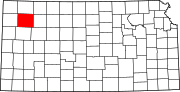 | |
| CDP | ||
| Unincorporated communities | ||
| Ghost towns | ||
| Footnotes | ‡This populated place also has portions in an adjacent county or counties | |
| International | |
|---|---|
| National | |
| Geographic | |
| Other | |