Файл:Apollo 17 Blue Marble original orientation (AS17-148-22727).jpg — Википедия

Исходный файл(2400 × 2400 пкс, размер файла: 5,97 Мб, MIME-тип: image/jpeg)

Краткое описание

 
Taken with a Hasselblad 500EL camera and 80mm Zeiss lens at stop setting f/2.8 on 70mm Ektachrome film of type SO-368
Описание
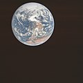
English: NASA original caption: View of the Earth as seen by the Apollo 17 crew on December 7, 1972, traveling toward the moon. This translunar coast photograph extends from the Mediterranean Sea area to the Antarctica south polar ice cap. This is the first time the Apollo trajectory made it possible to photograph the south polar ice cap. Note the heavy cloud cover in the Southern Hemisphere. Almost the entire coastline of Africa is clearly visible. The Arabian Peninsula can be seen at the northeastern edge of Africa. The large island off the east coast of Africa is the Republic of Madagascar. The Asian mainland is on the horizon toward the northeast.
Altitude: Roughly 29,400 km (18,300 miles)
Image center rough coordinates: 17°10'50"N 21°45'19"E
Earth disk center rough coordinates: 26°19’49”S 37°25’13”E
Дата UTC
Источник http://www.lpi.usra.edu/resources/apollo/frame/?AS17-148-22727 (image link)
Автор NASA
Другие версии
North-up orientation
Местоположение объекта26° 19′ 49″ ю. ш., 37° 25′ 13″ в. д. Kartographer map based on OpenStreetMap.Это и другие изображения по их местоположению на OpenStreetMapinfo
Это изображение или видеозапись внесены в каталог Космического центра имени Джонсона НАСА под идентификатором (Photo ID): AS17-148-22727.

Этот шаблон не указывает на правовой статус данной работы. По-прежнему необходим нормальный шаблон лицензий. См. Commons:Лицензирование.
Другие языки:

Лицензирование

Public domain Этот файл находится в общественном достоянии (англ. public domain), так как он был создан NASA (Национальным управлением по аэронавтике и исследованию космического пространства). Политика авторского права NASA гласит, что «Материал NASA не защищается авторским правом, если не указано иное». (См. Template:PD-USGov, страницу политики авторского права NASA или политику использования изображений JPL.)
Предупреждения:

Краткие подписи

Добавьте однострочное описание того, что собой представляет этот файл
The origin photo of the famous ‘Blue Marble’ image, depicting Earth (with the continents of Antarctica on top and Africa plus the Arabian Peninsula near the bottom) from roughly 29,400 km away, on 7 December 1972 at 10:39 UTC

image/jpeg

6 257 204 байт

2400 пиксель

2400 пиксель

История файла

Нажмите на дату/время, чтобы посмотреть файл, который был загружен в тот момент.

Дата/времяМиниатюраРазмерыУчастникПримечание
текущий08:40, 30 октября 2021Миниатюра для версии от 08:40, 30 октября 20212400 × 2400 (5,97 Мб)HuntsterReverted to version as of 08:21, 6 June 2015 (UTC); the differences are enough that this needs ot be uploaded to a new filename, but no source was given for this new version. Where did this significantly higher resolution come from...just a cleaned up version of File:EarthOverAfrica.jpg?
03:27, 30 октября 2021Миниатюра для версии от 03:27, 30 октября 20214400 × 4600 (2,72 Мб)Mistedspectaclehigher resolution & color correction
08:21, 6 июня 2015Миниатюра для версии от 08:21, 6 июня 20152400 × 2400 (5,97 Мб)Huntster{{Information |Description={{en|1=View of the Earth as seen by the Apollo 17 crew on December 7, 1972, traveling toward the moon. This translunar coast photograph extends from the Mediterranean Sea area to the Antarctica south polar ice cap. This is th...

Следующая страница использует этот файл:

Глобальное использование файла

Данный файл используется в следующих вики:

Метаданные