
 French
 Deutsch
ファイル:Un-croatia.svg

元のファイル (SVG ファイル、900 × 666 ピクセル、ファイルサイズ: 892キロバイト)
ウィキメディア・コモンズのファイルページにある説明を、以下に表示します。 |
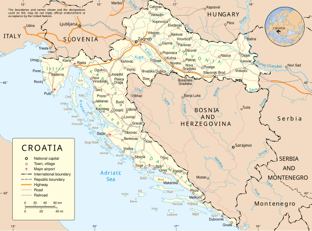
概要
| 解説 | English: Map of Croatia |
| 日付 | June 2004 converted to SVG date of upload |
| 原典 | Derived from UN Map of Croatia converted to SVG by me |
| 作者 | United Nations Cartographic Section. |
| その他のバージョン |
|


ライセンス
| This image is a map derived from a United Nations map. Unless stated otherwise, UN maps are to be considered in the public domain. This applies worldwide. UN maps are, in principle, open source material and you can use them in your work or for making your own map. UN requests however that you delete the UN name, logo and reference number upon any modification to the map. Content of your map will be your responsibility. You can state in your publication, if you wish, something like: based on UN map … (map name, map number, revision number and date). See: Geospatial Information Section. And: Geospatial, location data for a better world. |  |
ファイルの履歴
過去の版のファイルを表示するには、その版の日時をクリックしてください。
| 日付と時刻 | サムネイル | 寸法 | 利用者 | コメント | |
|---|---|---|---|---|---|
| 現在の版 | 2009年4月8日 (水) 01:50 | | 900 × 666 (892キロバイト) | DooFi | According to the UN-Map-Template "the UN name and reference number should not appear on any modified map". I deleted that information from the SVG as well as the border and also fixed some more ugly kerning errors |
| 2009年4月7日 (火) 22:29 |  | 903 × 695 (823キロバイト) | DooFi | Readable resolution, fixed 'A' in "HERZEGOVINA" and very little optimization | |
| 2008年11月25日 (火) 18:30 |  | 602 × 461 (562キロバイト) | RaviC | {{Information |Description={{en|Map of Croatia}} |Source=Derived from [http://www.un.org/Depts/Cartographic/map/profile/croatia.pdf UN Map of Croatia] converted to SVG by me |Author=United Nations Cartographic Section. |Date=June 2004 converted to SVG dat |
ファイルの使用状況
以下のページがこのファイルを使用しています:
グローバルなファイル使用状況
以下に挙げる他のウィキがこの画像を使っています:
- ar.wikipedia.org での使用状況
- ba.wikipedia.org での使用状況
- bg.wikipedia.org での使用状況
- ceb.wikipedia.org での使用状況
- de.wikipedia.org での使用状況
- dsb.wikipedia.org での使用状況
- en.wikipedia.org での使用状況
- frr.wikipedia.org での使用状況
- fr.wikipedia.org での使用状況
- gn.wikipedia.org での使用状況
- haw.wikipedia.org での使用状況
- hu.wikipedia.org での使用状況
- id.wikipedia.org での使用状況
- it.wikipedia.org での使用状況
- jbo.wikipedia.org での使用状況
- kaa.wikipedia.org での使用状況
- kk.wikipedia.org での使用状況
- krc.wikipedia.org での使用状況
- ln.wikipedia.org での使用状況
- mi.wikipedia.org での使用状況
- nov.wikipedia.org での使用状況
- pam.wikipedia.org での使用状況
- pap.wikipedia.org での使用状況
- pms.wikipedia.org での使用状況
- roa-rup.wikipedia.org での使用状況
- ru.wikipedia.org での使用状況
- sm.wikipedia.org での使用状況
- sq.wikipedia.org での使用状況
- sr.wikipedia.org での使用状況
- tt.wikipedia.org での使用状況
- vi.wikipedia.org での使用状況
- war.wikipedia.org での使用状況
- wo.wikipedia.org での使用状況
- zea.wikipedia.org での使用状況