
 French
 Deutsch
ファイル:ROC vs PRC.svg

この SVG ファイルのこの PNG プレビューのサイズ: 800 × 548 ピクセル. その他の解像度: 320 × 219 ピクセル | 640 × 439 ピクセル | 1,024 × 702 ピクセル | 1,280 × 878 ピクセル | 2,560 × 1,755 ピクセル | 1,339 × 918 ピクセル。
元のファイル (SVG ファイル、1,339 × 918 ピクセル、ファイルサイズ: 1.71メガバイト)
ウィキメディア・コモンズのファイルページにある説明を、以下に表示します。 |
概要
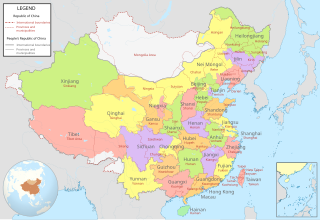
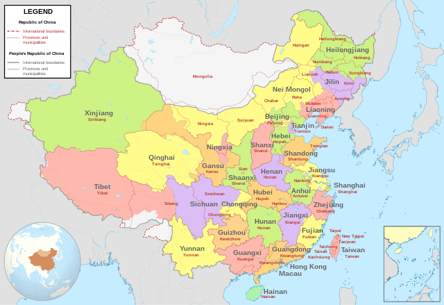
| 解説 | English: Comparison between Republic of China (1953-2002 in Taiwan) and People's Republic of China administrative divisions.
Adapted from File:ROC PRC comparison eng.jpg. The original ROC map included more cities, but the adaptation removed non-central municipalities to clean up the image. Therefore, this image contains: Republic of China
People's Republic of China
|
| 日付 | |
| 原典 | 次の画像を基にした投稿者自身による著作物: China (+claims, +Hainan), administrative divisions - Blank - colored.svg |
| 作者 | Milenioscuro |
,_administrative_divisions_-_Blank_-_colored.svg)
ライセンス
この作品の著作権者である私は、この作品を以下のライセンスで提供します。
このファイルはクリエイティブ・コモンズ 表示-継承 4.0 国際ライセンスのもとに利用を許諾されています。
- あなたは以下の条件に従う場合に限り、自由に
- 共有 – 本作品を複製、頒布、展示、実演できます。
- 再構成 – 二次的著作物を作成できます。
- あなたの従うべき条件は以下の通りです。
- 表示 – あなたは適切なクレジットを表示し、ライセンスへのリンクを提供し、変更があったらその旨を示さなければなりません。これらは合理的であればどのような方法で行っても構いませんが、許諾者があなたやあなたの利用行為を支持していると示唆するような方法は除きます。
- 継承 – もしあなたがこの作品をリミックスしたり、改変したり、加工した場合には、あなたはあなたの貢献部分を元の作品とこれと同一または互換性があるライセンスの下に頒布しなければなりません。
- ↑ “Taiwan Veto Likely; Taipei Regime May Again Bar Outer Mongolia From U.N.”, in The New York Times[1], 22 April 1961
- ↑ 中華民國年鑑. Archived from the original on April 19, 2003. Retrieved on January 21, 2017.
ファイルの履歴
過去の版のファイルを表示するには、その版の日時をクリックしてください。
| 日付と時刻 | サムネイル | 寸法 | 利用者 | コメント | |
|---|---|---|---|---|---|
| 現在の版 | 2022年7月15日 (金) 05:04 | | 1,339 × 918 (1.71メガバイト) | Tjs2012 | Adjust borders |
| 2021年4月11日 (日) 19:25 |  | 1,339 × 918 (1.71メガバイト) | Milenioscuro | the color reflects the political divisions of PRC, so Taiwan must be ONE color, disputed territories in white like original file | |
| 2020年6月15日 (月) 05:36 |  | 512 × 401 (1.43メガバイト) | Jrthsr700tmax | Add New Taipei, Taoyuan, Tainan | |
| 2020年2月15日 (土) 19:13 |  | 1,156 × 904 (2.18メガバイト) | Milenioscuro | colors of provinces | |
| 2020年2月1日 (土) 16:53 |  | 1,156 × 904 (2.18メガバイト) | Milenioscuro | User created page with UploadWizard |
ファイルの使用状況
以下のページがこのファイルを使用しています:
グローバルなファイル使用状況
以下に挙げる他のウィキがこの画像を使っています:
- en.wikipedia.org での使用状況
- es.wikipedia.org での使用状況
- mt.wikipedia.org での使用状況