
 French
 Deutsch
ファイル:PearlHarborCarrierChart.jpg

このプレビューのサイズ: 800 × 566 ピクセル。 その他の解像度: 320 × 226 ピクセル | 640 × 453 ピクセル | 1,004 × 710 ピクセル。
元のファイル (1,004 × 710 ピクセル、ファイルサイズ: 213キロバイト、MIME タイプ: image/jpeg)
ウィキメディア・コモンズのファイルページにある説明を、以下に表示します。 |
 | このmilitary map画像は、ベクターイメージである SVG ファイルとして再作成されるべきです。これにはいくつかの利点があります。詳しくはCommons:Media for cleanupを参照してください。この画像の SVG 形式がすでに利用可能である場合は、アップロードしてください。アップロード後、この画像にあるこのテンプレートを{{Vector version available|新しい画像ファイル名.svg}}テンプレートで置き換えてください。 |


概要
Español: La flota Japonesa se movilizó sin ser detectada rumbo a Pearl Harbor.
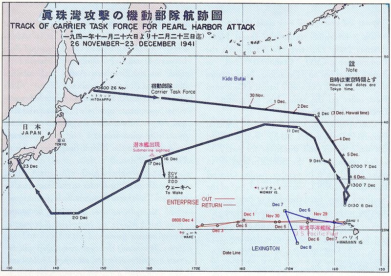
English: The route of the Japanese flotilla (Kido Butai), with the USS Enterprise (in red) and the USS Lexington (in blue) to the South.
Public Domain chart from "Reports of General MacArthur, prepared by his General Staff." This book was printed by GPO. The chart shows the routes of the Japanese attack force to and from Pearl Harbor. I have added the routes of the two American carriers.
このファイルは、アメリカ合衆国の連邦政府と雇用関係にある公務員がその職務上作成したアメリカ合衆国政府の著作物であり、アメリカ合衆国の著作権法上パブリックドメインに属します (17 U.S.C. §105)。 注意:このライセンスは、アメリカ合衆国政府の著作物についてのみ効力を有します。アメリカ合衆国の各州、郡、その他の地方自治体が作成した著作物に対しては適用できません。 |  | |
| このファイルは著作権法の既知の制約(隣接権や関連する権利を含む)から自由であると特定されています。 | ||
(got from en.wikipedia)
ファイルの履歴
過去の版のファイルを表示するには、その版の日時をクリックしてください。
| 日付と時刻 | サムネイル | 寸法 | 利用者 | コメント | |
|---|---|---|---|---|---|
| 現在の版 | 2005年10月18日 (火) 15:20 | | 1,004 × 710 (213キロバイト) | Unf~commonswiki | Public Domain chart from "Reports of General MacArthur, prepared by his General Staff." This book was printed by GPO. The chart shows the routes of the Japanese attack force to and from Pearl Harbor. I have added the routes of the two American carriers. |
ファイルの使用状況
以下のページがこのファイルを使用しています:
グローバルなファイル使用状況
以下に挙げる他のウィキがこの画像を使っています:
- af.wikipedia.org での使用状況
- ar.wikipedia.org での使用状況
- az.wikipedia.org での使用状況
- bg.wikipedia.org での使用状況
- ca.wikipedia.org での使用状況
- cs.wikipedia.org での使用状況
- da.wikipedia.org での使用状況
- en.wikipedia.org での使用状況
- et.wikipedia.org での使用状況
- fr.wikipedia.org での使用状況
- fy.wikipedia.org での使用状況
- he.wikipedia.org での使用状況
- hu.wikipedia.org での使用状況
- id.wikipedia.org での使用状況
- it.wikipedia.org での使用状況
- ms.wikipedia.org での使用状況
- nl.wikipedia.org での使用状況
- no.wikipedia.org での使用状況
- pl.wikipedia.org での使用状況
- pt.wikipedia.org での使用状況
- ru.wikipedia.org での使用状況
- sk.wikipedia.org での使用状況
- tr.wikipedia.org での使用状況
- ur.wikipedia.org での使用状況
- vi.wikipedia.org での使用状況
- zh.wikipedia.org での使用状況