
 French
 Deutsch
ファイル:PIA17202 - Approaching Enceladus.jpg
このプレビューのサイズ: 600 × 600 ピクセル。 その他の解像度: 240 × 240 ピクセル | 480 × 480 ピクセル | 1,020 × 1,020 ピクセル。
元のファイル (1,020 × 1,020 ピクセル、ファイルサイズ: 1.1メガバイト、MIME タイプ: image/jpeg)
ウィキメディア・コモンズのファイルページにある説明を、以下に表示します。 |
概要
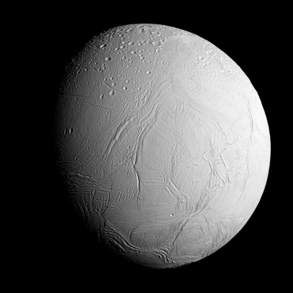
| 解説 | English: Original caption: NASA's Cassini spacecraft captured this view as it neared icy Enceladus for its closest-ever dive past the moon's active south polar region. The view shows heavily cratered northern latitudes at top, transitioning to fractured, wrinkled terrain in the middle and southern latitudes. The wavy boundary of the moon's active south polar region -- Cassini's destination for this flyby -- is visible at bottom, where it disappears into wintry darkness. This view looks towards the Saturn-facing side of Enceladus. North on Enceladus is up and rotated 23 degrees to the right. The image was taken in visible light with the Cassini spacecraft narrow-angle camera on Oct. 28, 2015. The view was acquired at a distance of approximately 60,000 miles (96,000 kilometers) from Enceladus and at a Sun-Enceladus-spacecraft, or phase, angle of 45 degrees. Image scale is 1,896 feet (578 meters) per pixel. |
| 日付 | |
| 原典 | PIA17202 from the NASA/JPL Photojournal |
| 作者 | National Aeronautics and Space Administration (NASA) / Jet Propulsion Laboratory (JPL) |
ライセンス
| このファイルはアメリカ航空宇宙局(NASA)によって作成されたものです。NASAの著作権の方針では、特記事項が無い場合、NASAの資料はパブリックドメインとなります。 (詳しくはTemplate:PD-USGov、NASAの著作権の方針について(英語)又はジェット推進研究所(JPL)の画像使用に関するガイドライン(英語)をご覧ください。) | ||
 | 注意事項:
|
ファイルの履歴
過去の版のファイルを表示するには、その版の日時をクリックしてください。
| 日付と時刻 | サムネイル | 寸法 | 利用者 | コメント | |
|---|---|---|---|---|---|
| 現在の版 | 2020年10月8日 (木) 07:20 | | 1,020 × 1,020 (1.1メガバイト) | Vlixes | from tiff, rgb |
| 2015年10月30日 (金) 23:16 |  | 920 × 920 (191キロバイト) | PhilipTerryGraham | User created page with UploadWizard |
ファイルの使用状況
以下のページがこのファイルを使用しています:
グローバルなファイル使用状況
以下に挙げる他のウィキがこの画像を使っています:
- an.wikipedia.org での使用状況
- ary.wikipedia.org での使用状況
- arz.wikipedia.org での使用状況
- azb.wikipedia.org での使用状況
- bn.wikibooks.org での使用状況
- bs.wikipedia.org での使用状況
- ca.wikipedia.org での使用状況
- ckb.wikipedia.org での使用状況
- cs.wikipedia.org での使用状況
- el.wikipedia.org での使用状況
- en.wikipedia.org での使用状況
- Pioneer 11
- Cassini–Huygens
- Enceladus
- Moons of Saturn
- Naming of moons
- List of natural satellites
- Dunyazad (crater)
- Ahmad (crater)
- Peri-Banu (crater)
- Aladdin (crater)
- Ali Baba (crater)
- Julnar (crater)
- Salih (crater)
- Dalilah (crater)
- Samad (crater)
- Musa (crater)
- Gharib (crater)
- Duban (crater)
- Shahryar (crater)
- Sindbad (crater)
- Daryabar Fossa
- Bassorah Fossa
- List of gravitationally rounded objects of the Solar System
- Al-Fakik
- Marjanah (crater)
- Ayyub (crater)
- Fitnah (crater)
- Ghanim (crater)
- Al-Haddar
- Sharrkan (crater)
- Khusrau (crater)
- Al-Kuz
- Shakashik (crater)
- Behram (crater)
- Zumurrud (crater)
- Jansha (impact crater)
このファイルのグローバル使用状況を表示する。