
 French
 Deutsch
ファイル:Europe biogeography countries en.svg

この SVG ファイルのこの PNG プレビューのサイズ: 800 × 564 ピクセル. その他の解像度: 320 × 225 ピクセル | 640 × 451 ピクセル | 1,024 × 722 ピクセル | 1,280 × 902 ピクセル | 2,560 × 1,804 ピクセル | 3,535 × 2,491 ピクセル。
元のファイル (SVG ファイル、3,535 × 2,491 ピクセル、ファイルサイズ: 710キロバイト)
ウィキメディア・コモンズのファイルページにある説明を、以下に表示します。 |
概要
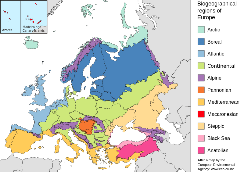
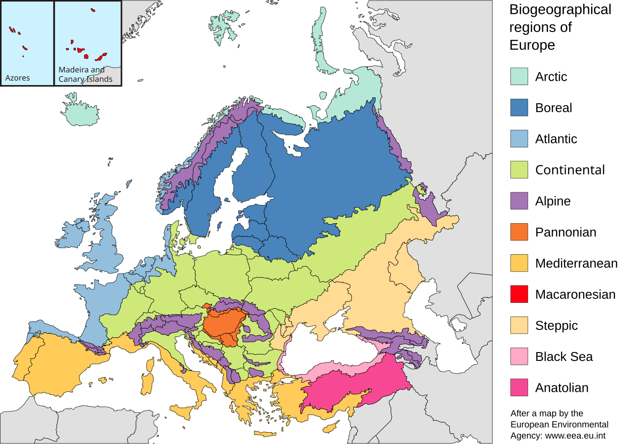
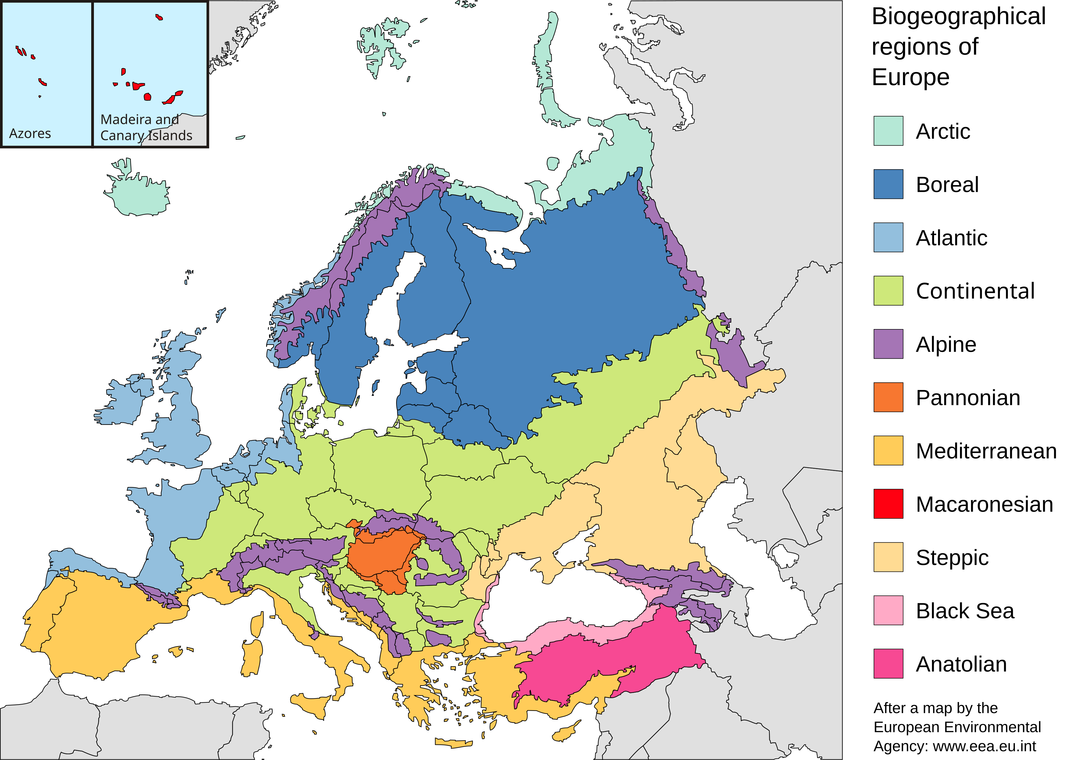
| 解説 | English: Map of the biogeographic regions of Europe, after EEA's map. Shows both country and biogeographical region boundaries. Legend in English. SVG format. Español: Regiones biogeográficas de Europa. Português: Regiões biogeográficas da Europa e regiões adjacentes. 한국어: Biogeographic regions. Biogeographic regions(Biogeographic regions. Türkçe: Avrupa'nın Biyocoğrafik Bölgeleri (Türkiye'nin Asya kısmı da dahil). Dansk: Pannonisk klima er her angivet med orange farve, der dækker dele af Slovakiet, Østrig, Serbien og Rumænien samt hele Ungarn. Galego: Rexións bioxeográficas de Europa. Norsk bokmål: Biogeografiske områder i Europa. Norsk nynorsk: Biogeografiske område i Europa. پښتو: Biogeographic regions of Europe. Mirandés: Regiones biogeográficas de la Ouropa. |
| 日付 | |
| 原典 | Made with Inkscape from Image:Biogeographical Regions Europe - Map (intl).png by the European Environmental Agency |
| 作者 | Júlio Reis |
| その他のバージョン | Regions only: Image:Europe biogeography regions.svg; blank map: Image:Europe biogeography blank.svg  |
.png)
ライセンス
このファイルはクリエイティブ・コモンズ 表示-継承 3.0 非移植ライセンスのもとに利用を許諾されています。
- あなたは以下の条件に従う場合に限り、自由に
- 共有 – 本作品を複製、頒布、展示、実演できます。
- 再構成 – 二次的著作物を作成できます。
- あなたの従うべき条件は以下の通りです。
- 表示 – あなたは適切なクレジットを表示し、ライセンスへのリンクを提供し、変更があったらその旨を示さなければなりません。これらは合理的であればどのような方法で行っても構いませんが、許諾者があなたやあなたの利用行為を支持していると示唆するような方法は除きます。
- 継承 – もしあなたがこの作品をリミックスしたり、改変したり、加工した場合には、あなたはあなたの貢献部分を元の作品とこれと同一または互換性があるライセンスの下に頒布しなければなりません。
ファイルの履歴
過去の版のファイルを表示するには、その版の日時をクリックしてください。
| 日付と時刻 | サムネイル | 寸法 | 利用者 | コメント | |
|---|---|---|---|---|---|
| 現在の版 | 2010年7月19日 (月) 20:41 | | 3,535 × 2,491 (710キロバイト) | Malus Catulus | Changed according graphic lab request: removed frame, hopefully fixed text, fixed some other stuff |
| 2006年5月23日 (火) 10:48 |  | 3,600 × 2,610 (876キロバイト) | Tintazul | {{Tintazul| |Description=Map of the biogeographic regions of Europe, after EEA's map. Shows both country and biogeographical region boundaries. Legend in English. SVG format. |Date=20 May 2006 |Source=Made with Inkscape from [[:Image:Biogeographical Regi |
ファイルの使用状況
以下のページがこのファイルを使用しています:
グローバルなファイル使用状況
以下に挙げる他のウィキがこの画像を使っています:
- ar.wikipedia.org での使用状況
- azb.wikipedia.org での使用状況
- az.wikipedia.org での使用状況
- beta.wikiversity.org での使用状況
- bn.wikipedia.org での使用状況
- bs.wikipedia.org での使用状況
- cs.wikipedia.org での使用状況
- da.wikipedia.org での使用状況
- el.wikipedia.org での使用状況
- en.wikipedia.org での使用状況
- Geography of Armenia
- Europe
- Biogeography
- Pannonian Basin
- Template talk:Greek diaspora
- User:Engram
- Fauna of Europe
- User:Whytecypress/UserboxCaucasian
- Portal:Maps/Maps/Geographic
- User talk:BadYodels
- Portal:Maps/Maps/Geographic/6
- User:Kaarel/sandbox/Fauna of Europe
- List of butterflies of Europe
- Mediterranean Biogeographic Region
- Arctic Biogeographic Region
- Boreal Biogeographic Region
- Biogeographic regions of Europe
- Atlantic Biogeographic Region
- Continental Biogeographic Region
- Anatolian Biogeographic Region
- Black Sea Biogeographic Region
- Macaronesian Biogeographic Region
- Alpine Biogeographic Region
- Pannonian Biogeographic Region
- Steppic Biogeographic Region
- en.wikiversity.org での使用状況
- eo.wikipedia.org での使用状況
- es.wikipedia.org での使用状況
- fa.wikipedia.org での使用状況
- ga.wikipedia.org での使用状況
- gl.wikipedia.org での使用状況
- hy.wikipedia.org での使用状況
- ka.wikipedia.org での使用状況
このファイルのグローバル使用状況を表示する。