
 French
 Deutsch
ファイル:Europe 1812 map en.png

このプレビューのサイズ: 800 × 526 ピクセル。 その他の解像度: 320 × 211 ピクセル | 640 × 421 ピクセル | 1,024 × 674 ピクセル | 1,280 × 842 ピクセル | 2,284 × 1,503 ピクセル。
元のファイル (2,284 × 1,503 ピクセル、ファイルサイズ: 1.14メガバイト、MIME タイプ: image/png)
ウィキメディア・コモンズのファイルページにある説明を、以下に表示します。 |
概要
 | このhistorical map画像は、ベクターイメージである SVG ファイルとして再作成されるべきです。これにはいくつかの利点があります。詳しくはCommons:Media for cleanupを参照してください。この画像の SVG 形式がすでに利用可能である場合は、アップロードしてください。アップロード後、この画像にあるこのテンプレートを{{Vector version available|新しい画像ファイル名.svg}}テンプレートで置き換えてください。 |
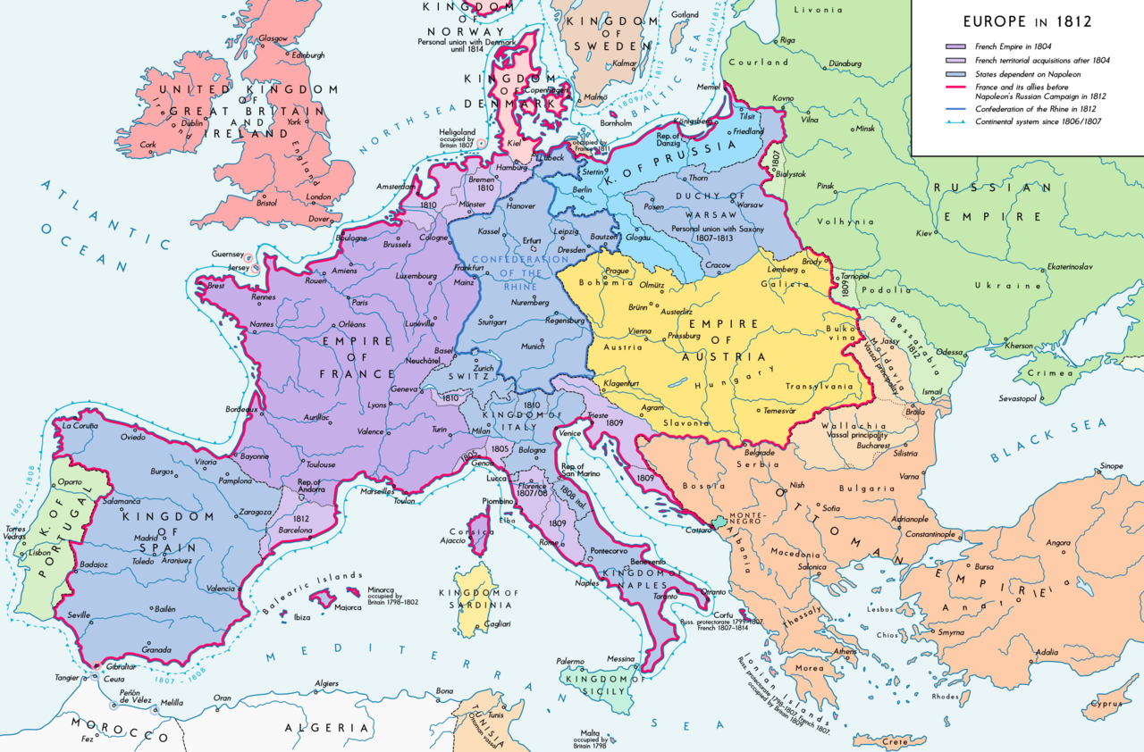
| 解説 | Deutsch: Europa 1812. Politische Ausgangslage vor Napeoleons Russlandfelzug. English: Europe in 1812. Political situation before Napoleon's Russian Campaign. |
| 日付 | |
| 原典 | 投稿者自身による著作物. Source of Information: – Map "L'apogée de l'Empire Français (avant la campagne de Russie)" (Author unknown)(Link) – Dr. Walter Leiserung (ed.): Historischer Weltatlas, Marix Verlag, Wiesbaden 2004, ISBN 978-3-937715-59-9 – Zentralinstitut für Geschichte der Akademie der Wissenschaften der DDR (ed.): Atlas zur Geschichte, Band 1, VEB Hermann Haack, Gotha 1989, ISBN 3-7301-0040-8 – Prof. Dr. Vadim Oswalt, Prof. Dr. Hans Ulrich Rudolf (ed.): Klett-Perthes Atlas zur Weltgeschichte, Ernst Klett Verlag, Stuttgart 2011, ISBN 978-3-12-828194-0 – Ferenc Majoros u. Bernd Rill: Das Osmanische Reich 1300-1922. Die Geschichte einer Großmacht, Lzenzausgabe für Weltbild Verlag, Augsburg 2000, ISBN 3-8289-0336-3 |
| 作者 | Alexander Altenhof |
| その他のバージョン |
|


_en.png)
.png)
.jpg)
ライセンス
この作品の著作権者である私は、この作品を以下のライセンスで提供します。
このファイルはクリエイティブ・コモンズ 表示-継承 3.0 非移植ライセンスのもとに利用を許諾されています。
- あなたは以下の条件に従う場合に限り、自由に
- 共有 – 本作品を複製、頒布、展示、実演できます。
- 再構成 – 二次的著作物を作成できます。
- あなたの従うべき条件は以下の通りです。
- 表示 – あなたは適切なクレジットを表示し、ライセンスへのリンクを提供し、変更があったらその旨を示さなければなりません。これらは合理的であればどのような方法で行っても構いませんが、許諾者があなたやあなたの利用行為を支持していると示唆するような方法は除きます。
- 継承 – もしあなたがこの作品をリミックスしたり、改変したり、加工した場合には、あなたはあなたの貢献部分を元の作品とこれと同一または互換性があるライセンスの下に頒布しなければなりません。
ファイルの履歴
過去の版のファイルを表示するには、その版の日時をクリックしてください。
| 日付と時刻 | サムネイル | 寸法 | 利用者 | コメント | |
|---|---|---|---|---|---|
| 現在の版 | 2016年9月11日 (日) 15:26 | | 2,284 × 1,503 (1.14メガバイト) | KaterBegemot | Border corrections at Thorn and Tarnopol area, minor kerning and positioning changes |
| 2016年7月20日 (水) 00:47 |  | 2,284 × 1,503 (1.14メガバイト) | KaterBegemot | Added Bukovina / Corrected spelling of Sevastopol, Courland, Belgrade, Duchy of Warsaw / Marked Corfu as territory under French influence (red) / Correct position of city points of Basel, Geneva, Toulouse / Minor border corrections / Better kerning / T... | |
| 2016年7月14日 (木) 00:21 |  | 2,284 × 1,503 (1.14メガバイト) | KaterBegemot | Added P. of Neuchatel, Ekaterinoslav, Varna, Brăila / Corrected borders of Montenegro, Milan-Genoa area | |
| 2015年12月3日 (木) 00:43 |  | 2,284 × 1,503 (1.09メガバイト) | Ras67 | frame cropped | |
| 2015年11月29日 (日) 11:31 |  | 2,293 × 1,512 (1.12メガバイト) | Spiridon Ion Cepleanu | Some details & corrections in the Austrian & Ottoman empires, according with « Grosser Atlas zur Weltgeschichte » (H.E.Stier, dir.) Westermann 1985, ISBN 3-14-100919-8, « Putzger historischer Weltatlas Cornelsen » 1990, ISBN 3-464-00176-8, « Atlas... | |
| 2013年10月5日 (土) 21:47 |  | 2,293 × 1,512 (1.01メガバイト) | KaterBegemot | Corrected boundaries of Switzerland, Prussia and Circassia | |
| 2012年9月15日 (土) 23:53 |  | 2,293 × 1,512 (1.01メガバイト) | KaterBegemot | == {{int:filedesc}} == {{Information |Description= {{de|1=Europa 1812. Politische Ausgangslage vor Napeoleons Russlandfelzug.}}{{en|1=Europe in 1812. Political situation before Napoleon's Russian Campaign.}} |Source={{Own}}. Source of Information: </br... |
ファイルの使用状況
以下の 3 ページがこのファイルを使用しています:
グローバルなファイル使用状況
以下に挙げる他のウィキがこの画像を使っています:
- af.wikipedia.org での使用状況
- azb.wikipedia.org での使用状況
- br.wikipedia.org での使用状況
- ca.wikipedia.org での使用状況
- ce.wikipedia.org での使用状況
- cs.wikipedia.org での使用状況
- da.wikipedia.org での使用状況
- de.wikipedia.org での使用状況
- el.wikipedia.org での使用状況
- en.wikipedia.org での使用状況
- History of Austria
- Napoleonic Wars
- Puppet state
- Napoleon
- Client state
- Klemens von Metternich
- France in the long nineteenth century
- Ideas of European unity before 1948
- Principality of Erfurt
- First French Empire
- Territorial evolution of France
- French invasion of Russia
- Alexander I of Russia
- Wikipedia talk:GLAM/Israel Museum, Jerusalem
- French period
- History of French foreign relations
- List of French client states
- International relations (1648–1814)
- Conference of Dresden (1812)
- User:Falcaorib
- en.wikibooks.org での使用状況
- eo.wikipedia.org での使用状況
- es.wikipedia.org での使用状況
- fi.wikipedia.org での使用状況
- fr.wikipedia.org での使用状況
- fy.wikipedia.org での使用状況
- hr.wikipedia.org での使用状況
このファイルのグローバル使用状況を表示する。