
 French
 Deutsch
ファイル:Dardanelles defences 1915.png
このプレビューのサイズ: 580 × 599 ピクセル。 その他の解像度: 232 × 240 ピクセル | 600 × 620 ピクセル。
元のファイル (600 × 620 ピクセル、ファイルサイズ: 137キロバイト、MIME タイプ: image/png)
ウィキメディア・コモンズのファイルページにある説明を、以下に表示します。 |
 | この地図画像は、ベクターイメージである SVG ファイルとして再作成されるべきです。これにはいくつかの利点があります。詳しくはCommons:Media for cleanupを参照してください。この画像の SVG 形式がすでに利用可能である場合は、アップロードしてください。アップロード後、この画像にあるこのテンプレートを{{Vector version available|新しい画像ファイル名.svg}}テンプレートで置き換えてください。 |
概要
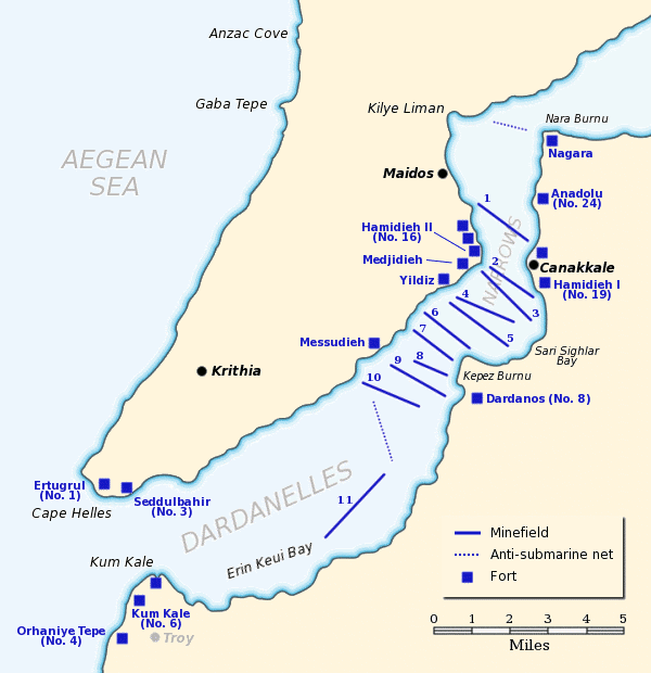
| 解説 | English: Map of the Dardanelles defences in February and March, 1915. The original lines of naval mines are numbered 1 to 10. The 11th line, laid in Erin Keui Bay by the minelayer Nusrat on 8 March, is numbered 11. The anti-submarine nets are shown as dotted lines. Major forts are indicated with blue boxes and the Turkish name and equivalent British number for the fort is given, if known. |
| 日付 | |
| 原典 | 次の画像を基にした投稿者自身による著作物:
|
| 作者 | Gsl |
| 許可 (ファイルの再利用) | Released to public domain |
| この著作物は、著作者であるGslによって権利が放棄され、パブリックドメインとされました。これは全世界で適用されます。 一部の国では、これが法的に可能ではない場合があります。その場合は、次のように宣言します。 |
ファイルの履歴
過去の版のファイルを表示するには、その版の日時をクリックしてください。
| 日付と時刻 | サムネイル | 寸法 | 利用者 | コメント | |
|---|---|---|---|---|---|
| 現在の版 | 2012年6月21日 (木) 18:02 | | 600 × 620 (137キロバイト) | Hohum | Clearer colours |
| 2005年6月22日 (水) 16:51 |  | 600 × 620 (74キロバイト) | Redtony | Map of the Dardanelles defences in February and March, 1915. The original lines of naval mines are numbered 1 to 10. The 11th line, laid in Erin Keui Bay by the minelayer ''Nusrat'' on 8 March, is numbered 11. The anti-submarine nets are shown as d |
ファイルの使用状況
以下のページがこのファイルを使用しています:
グローバルなファイル使用状況
以下に挙げる他のウィキがこの画像を使っています:
- ast.wikipedia.org での使用状況
- be-tarask.wikipedia.org での使用状況
- be.wikipedia.org での使用状況
- bg.wikipedia.org での使用状況
- ca.wikipedia.org での使用状況
- de.wikipedia.org での使用状況
- en.wikipedia.org での使用状況
- HMS Ocean (1898)
- HMS Goliath (1898)
- HMS Irresistible (1898)
- Naval operations in the Dardanelles campaign
- HMS Albion (1898)
- Lord Nelson-class battleship
- Eric Gascoigne Robinson
- French battleship Suffren
- HMS Cornwallis (1901)
- SMS Kurfürst Friedrich Wilhelm
- SMS Weissenburg
- HMS Agamemnon (1906)
- Charlemagne-class battleship
- French battleship Gaulois
- French battleship Charlemagne
- HMS Vengeance (1899)
- Dardanelles Fortified Area Command
- Gulf of Erenköy
- Ottoman minelayer Intibah
- es.wikipedia.org での使用状況
- fr.wikipedia.org での使用状況
- he.wikipedia.org での使用状況
- it.wikipedia.org での使用状況
- ka.wikipedia.org での使用状況
- pl.wikipedia.org での使用状況
このファイルのグローバル使用状況を表示する。