
 French
 Deutsch
ファイル:Acprussiamap2.gif
高解像度版はありません。
Acprussiamap2.gif (510 × 357 ピクセル、ファイルサイズ: 27キロバイト、MIME タイプ: image/gif、0.1秒)
ウィキメディア・コモンズのファイルページにある説明を、以下に表示します。 |

This image was copied from wikipedia:pt. The original description was:
Licença GNU, fonte en:Wikipedia.
 | この文書は、フリーソフトウェア財団発行のGNUフリー文書利用許諾書 (GNU Free Documentation License) 1.2またはそれ以降のバージョンの規約に基づき、複製や再配布、改変が許可されます。不可変更部分、表紙、背表紙はありません。このライセンスの複製は、GNUフリー文書利用許諾書という章に含まれています。 |
| このファイルはクリエイティブ・コモンズ 表示-継承 3.0 非移植ライセンスのもとに利用を許諾されています。 | ||
| ||
| このライセンスのテンプレートは、GFDLのライセンス・アップデートによりこのファイルに追加されたものです。 |
 | This map has been uploaded by Electionworld from en.wikipedia.org to enable the |
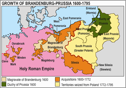
Growth of Prussia en:Image:Ac.prussiamap2.gif
 | このhistorical map画像は、ベクターイメージである SVG ファイルとして再作成されるべきです。これにはいくつかの利点があります。詳しくはCommons:Media for cleanupを参照してください。この画像の SVG 形式がすでに利用可能である場合は、アップロードしてください。アップロード後、この画像にあるこのテンプレートを{{Vector version available|新しい画像ファイル名.svg}}テンプレートで置き換えてください。 |
ファイルの履歴
過去の版のファイルを表示するには、その版の日時をクリックしてください。
| 日付と時刻 | サムネイル | 寸法 | 利用者 | コメント | |
|---|---|---|---|---|---|
| 現在の版 | 2020年3月15日 (日) 13:17 | | 510 × 357 (27キロバイト) | E-960 | Ermland, correction. |
| 2020年3月15日 (日) 12:50 |  | 510 × 357 (27キロバイト) | E-960 | Names of territories and format. | |
| 2009年6月1日 (月) 19:44 |  | 510 × 357 (14キロバイト) | Hohum | Changed colours to more cartographic, less garish. Made sea blue instead of portions of land. | |
| 2006年8月25日 (金) 18:36 |  | 510 × 357 (15キロバイト) | LeonardoG | This image was copied from wikipedia:pt. The original description was: Licença GNU, fonte en:Wikipedia. {{GFDL}} en:Image:Ac.prussiamap2.gif {| border="1" ! date/time || username || resolution || size || edit summary |---- | |} |
ファイルの使用状況
以下の 3 ページがこのファイルを使用しています:
グローバルなファイル使用状況
以下に挙げる他のウィキがこの画像を使っています:
- af.wikipedia.org での使用状況
- ar.wikipedia.org での使用状況
- ast.wikipedia.org での使用状況
- bg.wikipedia.org での使用状況
- ca.wikipedia.org での使用状況
- cs.wikipedia.org での使用状況
- el.wikipedia.org での使用状況
- en.wikipedia.org での使用状況
- History of Germany
- House of Hohenzollern
- Prussia
- Margraviate of Brandenburg
- Prussian Army
- Territorial evolution of Germany
- Subdivisions of the Polish–Lithuanian territories following the partitions
- Prussian Partition
- 18th-century history of Germany
- Brandenburg–Pomeranian conflict
- Treaty of Vossem (1673)
- User:Falcaorib
- User:JMvanDijk/Sandbox 9/Box 15/Box 3
- es.wikipedia.org での使用状況
- et.wikipedia.org での使用状況
- eu.wikipedia.org での使用状況
- fa.wikipedia.org での使用状況
- fi.wikipedia.org での使用状況
- fr.wikipedia.org での使用状況
- he.wikipedia.org での使用状況
- hy.wikipedia.org での使用状況
- it.wikipedia.org での使用状況
このファイルのグローバル使用状況を表示する。