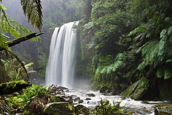
 Hopetoun Falls, Parc national Great Otway, Victoria.
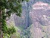
 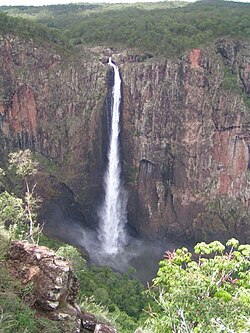 Wallaman Falls, Parc national Girringun, Queensland, la plus haute chute du pays.
 Cette page est une liste des chutes d'eau d'Australie.
Chutes d'eau de Nouvelle-Galles du Sud | Image | Chute | Lieu | Hauteur (m) | Type | Coordonnées |
 | Apsley Falls[2] | Parc national des Oxley Wild Rivers | 114 | | 31° 02′ 58″ S, 151° 46′ 05″ E |
 | Belmore Falls | Parc national Morton | 78 m[3] | | 34° 38′ 20″ S, 150° 33′ 34″ E |
 | Carrington Falls[2] | Parc national Budderoo | 50 | | 34° 37′ 28″ S, 150° 39′ 17″ E |
 | Chandler Falls | Parc national des Oxley Wild Rivers | | | |
 | Crystal Shower Falls | Parc national Dorrigo, Waterfall Way | | | 30° 22′ 40″ S, 152° 44′ 02″ E |
 | Dangar Falls[2] | près de Dorrigo | | | 30° 19′ 40″ S, 152° 42′ 53″ E |
 | Dangars Falls[2] | Parc national des Oxley Wild Rivers | 120 | | |
 | Ebor Falls[2] | Parc national de la rivière Guy Fawkes, Waterfall Way | | | 30° 24′ 08″ S, 152° 20′ 30″ E |
 | Ellenborough Falls[2] | près du Parc national Tapin Tops | | | 31° 36′ 44″ S, 152° 17′ 40″ E |
 | Empress Falls | près de Wentworth Falls | | | 33° 43′ 15″ S, 150° 21′ 33″ E |
 | Fitzroy Falls[4] | Park national Morton | | | 34° 39′ S, 150° 29′ E |
 | Kalang Falls | Parc national Kanangra-Boyd | | | 33° 58′ 48″ S, 150° 06′ 05″ E |
 | Katoomba Falls[5] | Parc national des Blue Mountains | | | 33° 43′ 40″ S, 150° 18′ 15″ E |
 | Minyon Falls[6] | Parc national Nightcap | 104 | | 28° 36′ 01″ S, 153° 23′ 23″ E |
 | Newell Falls | Parc national Dorrigo, Waterfall Way | | | 30° 23′ 37″ S, 152° 44′ 44″ E |
 | Protestors Falls[7] | Parc national Nightcap | 25 | | 28° 34′ 12″ S, 153° 18′ 17″ E |
 | Tin Mine Falls[2] | Parc national du Kosciuszko | | | |
 | Wentworth Falls[2] | Wentworth Falls | | | 33° 43′ 38″ S, 150° 22′ 26″ E |
| Wollomombi Falls[2] | Parc national des Oxley Wild Rivers, Waterfall Way | | | 30° 31′ 56″ S, 152° 02′ 23″ E |
Chutes d'eau du Queensland | Image | Chute | Lieu | Hauteur (m) | Type | Coordonnées |
 | Alligator Creek Falls | Bowling Green Bay National Park | | | |
 | Kondalilla Falls[14] | près de Mapleton | | | |
 | Malanda Falls | Atherton Tableland | | | 17° 21′ 18″ S, 145° 35′ 11″ E |
 | Millaa Millaa Falls | Atherton Tableland Waterfall Circuit | 18.3[15] | Chute | 17° 29′ 44″ S, 145° 36′ 36″ E |
 | Millstream Falls | Millstream Falls National Park | | | 17° 38′ 35″ S, 145° 27′ 27″ E |
 | Morans Falls | Lamington National Park | 80[réf. nécessaire] | Chute | 28° 13′ 50″ S, 153° 07′ 29″ E |
 | Murray Falls | Parc national de la vallée du Murray | 20-30[16] | Cascade | 18° 09′ 10″ S, 145° 49′ 09″ E |
 | Natural Bridge Falls | Springbrook National Park | | | 28° 11′ 49″ S, 153° 14′ 24″ E |
 | Teviot Falls | McPherson Range près de Wilson's Peak | 38[17] | Chute | 28° 14′ 00″ S, 152° 29′ 00″ E |
 | Tully Falls | Tully Gorge National Park | 180-210[18] | Chute, Queue-de-cheval | 17° 47′ 00″ S, 145° 34′ 00″ E |
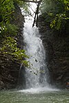
 | Wallaman Falls | Parc national Girringun | 305[19] | Cascade, Queue-de-cheval | 18° 35′ 32″ S, 145° 48′ 05″ E |
Chutes d'eau de Tasmanie | Image | Nom | Lieu | Hauteur (m) | Type | Coordonnées |
 | Dip Falls | Dip Range Regional Reserve,
North West Tasmania | 22-34[21] | Cascade | 41° 01′ 48″ S, 145° 22′ 12″ E |
 | Chutes Horseshoe | Parc national du mont Field | | Nivelée-cascade | 42° 40′ 12″ S, 146° 42′ 36″ E |
 | Chutes Lady Barron | Parc national du Mont-Field | | Nivelée-cascade | 42° 41′ 24″ S, 146° 41′ 24″ E |
 | Liffey Falls | Meander Valley, Midlands | 120-160[22] | Nivelée-cascade | 41° 41′ 24″ S, 146° 45′ 36″ E |
 | Chutes Marriott | Parc national du Mont-Field | | Nivelée-cascade | 42° 41′ 24″ S, 146° 41′ 24″ E |
 | Montezuma Falls | West Coast Range | 103-110[23],[24] | Queue-de-cheval | 41° 49′ 48″ S, 145° 28′ 12″ E |
 | Nelson Falls | Parc national des Franklin-Gordon Wild Rivers | 30[25] | Cascade | 42° 05′ 24″ S, 145° 43′ 48″ E |
 | Chutes Russell | Parc national du Mont-Field | 34-58[26] | Nivelée-cascade | 42° 40′ 12″ S, 146° 42′ 36″ E |
Chutes d'eau de Victoria | Image | Nom | Lieu | Hauteur (m) | Type | Coordonnées |
 | Hopkins Falls | près de Warrnambool | 11-13[27] | | 38° 20′ 01″ S, 143° 37′ 08″ E |
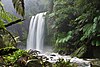 | Hopetoun Falls | Great Otway National Park, près de Beech Forest | 46-49[28] | | 38° 39′ 26″ S, 143° 34′ 47″ E |
 | Nigretta Falls | près de Coleraine | 15-16[29] | | 37° 39′ 22″ S, 141° 55′ 28″ E |
 | Silverband Falls | Grampians National Park | | | 37° 09′ 09,56″ S, 142° 31′ 39,7″ E |
 | Trentham Falls | Trentham | 44-48[30] | | 37° 22′ 12″ S, 144° 19′ 26″ E |
 | Triplet Falls | Great Otway National Park, Marreeyn section | | | 38° 39′ 33″ S, 143° 29′ 38″ E |
 | Wannon Falls | près de Coleraine | 18-22[31] | | 37° 40′ 35″ S, 141° 50′ 27″ E |
- ↑ « Map of Gibraltar Falls, ACT », Bonzle Digital Atlas of Australia (consulté le )
- ↑ a b c d e f g h et i « Name search », New South Wales Government (Geographical Names Board) (consulté le )
- ↑ « Belmore Falls - Robertson », Visit NSW (consulté le )
- ↑ « Parc national Morton - Fitzroy Falls », Department of Environment and Climate Change (consulté le )
- ↑ « Wild Walks » (consulté le )
- ↑ « Minyon Falls », New South Wales Government (consulté le )
- ↑ « Protestors Falls », New South Wales Government (consulté le )
- ↑ « Map of Edith Falls, NT », Bonzle Digital Atlas of Australia (consulté le )
- ↑ « Map of Florence Falls, NT », Bonzle Digital Atlas of Australia (consulté le )
- ↑ « Map of Jim Jim Falls (Barrkmalam), NT », Bonzle Digital Atlas of Australia (consulté le )
- ↑ « Map of Tolmer Falls, NT », Bonzle Digital Atlas of Australia (consulté le )
- ↑ « Map of Gungkurdul (Twin Falls), NT », Bonzle Digital Atlas of Australia (consulté le )
- ↑ « Map of Wangi Falls, NT », Bonzle Digital Atlas of Australia (consulté le )
- ↑ « Map of Kondalilla Falls, QLD », Bonzle Digital Atlas of Australia (consulté le )
- ↑ « Millaa Millaa Falls », World of Waterfalls, (consulté le )
- ↑ « Murray Falls », World of Waterfalls, Johnny T. Cheng,
- ↑ « Daggs Falls », World of Waterfalls, Johnny T. Cheng, (consulté le )
- ↑ « Tully Falls », World Waterfall Database, (consulté le )
- ↑ « Education: Significant Waterfalls », Geoscience Australia, Australian Government, (consulté le )
- ↑ « Morialta Conservation Park », South Australia Tourism, Government of South Australia (consulté le )
- ↑ « Dip Falls », Bonzle Digital Atlas of Australia (consulté le )
- ↑ « Map of Liffey Falls, TAS », Bonzle Digital Atlas of Australia (consulté le )
- ↑ « Montezuma Falls », World Waterfall Database, (consulté le )
- ↑ « Montezuma Falls Area, Roseberry, TAS, Australia », Australian Heritage Database: Register of the National Estate (consulté le )
- ↑ « Nelson Falls », World of Waterfalls, Johnny T. Cheng, (consulté le )
- ↑ « Map of Russell Falls, TAS », Bonzle Digital Atlas of Australia (consulté le )
- ↑ « Map of Hopkins Falls, VIC », Bonzle Digital Atlas of Australia (consulté le )
- ↑ « Map of Hopetoun Falls, VIC », Bonzle Digital Atlas of Australia (consulté le )
- ↑ « Map of Nigretta Falls, VIC », Bonzle Digital Atlas of Australia (consulté le )
- ↑ « Map of Trentham Falls, VIC », Bonzle Digital Atlas of Australia (consulté le )
- ↑ « Map of Wannon Falls, VIC », Bonzle Digital Atlas of Australia (consulté le )

 French
 Deutsch


.JPG)


.svg)