
 French
 Deutsch
پرونده:Special member state territories and the European Union.svg - ویکیپدیا، دانشنامهٔ آزاد

حجم پیشنمایش PNG این SVG file:۵۱۲ × ۲۵۸ پیکسل کیفیتهای دیگر: ۳۲۰ × ۱۶۱ پیکسل | ۶۴۰ × ۳۲۳ پیکسل | ۱٬۰۲۴ × ۵۱۶ پیکسل | ۱٬۲۸۰ × ۶۴۵ پیکسل | ۲٬۵۶۰ × ۱٬۲۹۰ پیکسل.
پروندهٔ اصلی (پروندهٔ اسویجی، با ابعاد ۵۱۲ × ۲۵۸ پیکسل، اندازهٔ پرونده: ۸۳۵ کیلوبایت)
این پرونده در ویکیانبار موجود است. محتویات صفحهٔ توصیف آن در زیر نمایش داده میشود. |
خلاصه
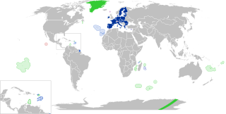
| توضیح | English: European Union Outermost regions Overseas countries and territories Special cases Other special territories Français : Union européenne Régions ultrapériphériques Pays et territoires d'outre-mer Cas spéciaux Autres territoires spéciaux |
| تاریخ | |
| منبع | اثر شخصی |
| پدیدآور | Glentamara |
| SVG genesis | کد مبدأ این پروندهٔ گرافیک برداری مقیاسپذیر، معتبر. این نقشهٔ جهان با Inkscape ساخته شده است, or with something else. |
اجازهنامه
| من، دارنده حق تکثیر این اثر، این اثر را به مالکیت عمومی منتشر میکنم. این قابل اجرا در تمام نقاط جهان است. در برخی از کشورها ممکن است به صورت قانونی این امکانپذیر نباشد؛ اگر چنین است: من اجازهٔ استفاده از این اثر را برای هر مقصودی، بدون هیچگونه شرایطی میدهم، تا وقتی که این شرایط توسط قانون مستلزم نشده باشد. |
تاریخچهٔ پرونده
روی تاریخ/زمانها کلیک کنید تا نسخهٔ مربوط به آن هنگام را ببینید.
| تاریخ/زمان | بندانگشتی | ابعاد | کاربر | توضیح | |
|---|---|---|---|---|---|
| کنونی | ۸ ژوئن ۲۰۲۲، ساعت ۱۹:۱۲ | | ۵۱۲ در ۲۵۸ (۸۳۵ کیلوبایت) | Nablicus | new version |
| ۱۷ ژوئیهٔ ۲۰۲۰، ساعت ۱۰:۱۳ |  | ۵۱۲ در ۲۵۹ (۷۳۶ کیلوبایت) | Alcaios | fixed – those were models I use to check the scale | |
| ۱۶ ژوئیهٔ ۲۰۲۰، ساعت ۲۳:۰۳ |  | ۵۱۲ در ۲۵۸ (۶۷۲ کیلوبایت) | Nablicus | Reverted to version as of 19:08, 16 July 2020 (UTC). There is an extra UK and Iceland in the middle of Canada... | |
| ۱۶ ژوئیهٔ ۲۰۲۰، ساعت ۱۹:۵۳ |  | ۵۱۲ در ۲۵۹ (۷۵۳ کیلوبایت) | Alcaios | frame | |
| ۱۶ ژوئیهٔ ۲۰۲۰، ساعت ۱۹:۵۰ |  | ۵۱۲ در ۲۵۸ (۶۸۱ کیلوبایت) | Alcaios | minor fixed on Greenland mar. zone | |
| ۱۶ ژوئیهٔ ۲۰۲۰، ساعت ۱۹:۴۶ |  | ۵۱۲ در ۲۵۸ (۶۸۱ کیلوبایت) | Alcaios | Added maritime zone of Gree,land based on https://www.marineregions.org/eezdetails.php?mrgid=8438 | |
| ۱۶ ژوئیهٔ ۲۰۲۰، ساعت ۱۹:۳۲ |  | ۵۱۲ در ۲۵۹ (۷۵۲ کیلوبایت) | Alcaios | added Faroe Islands' maritime zone | |
| ۱۶ ژوئیهٔ ۲۰۲۰، ساعت ۱۹:۰۸ |  | ۵۱۲ در ۲۵۸ (۶۷۲ کیلوبایت) | Alcaios | Maritime zones in the eastern Caribbean at the right scale, with the help of https://commons.wikimedia.org/wiki/File:Caribbean_maritime_boundaries_map.svg | |
| ۱۶ ژوئیهٔ ۲۰۲۰، ساعت ۱۸:۴۴ |  | ۵۱۲ در ۲۵۹ (۷۴۲ کیلوبایت) | Alcaios | slight realignments | |
| ۱۶ ژوئیهٔ ۲۰۲۰، ساعت ۱۸:۳۸ |  | ۵۱۲ در ۲۵۹ (۷۴۲ کیلوبایت) | Alcaios | typo in previous edit, read: "Northern Cyprus is not a special member state territory since..." –– the Åland archipelago is larger and almost reaches the Finnish coast |
کاربرد پرونده
صفحهٔ زیر از این تصویر استفاده میکند:
کاربرد سراسری پرونده
ویکیهای دیگر زیر از این پرونده استفاده میکنند:
- کاربرد در ar.wikipedia.org
- کاربرد در br.wikipedia.org
- کاربرد در cs.wikipedia.org
- کاربرد در de.wikipedia.org
- کاربرد در en.wikipedia.org
- European Union
- Neocolonialism
- Outline of the European Union
- Special territories of members of the European Economic Area
- Potential enlargement of the European Union
- External border of the European Union
- User:Falcaorib
- User:Xicomaia/sandbox
- User:Spinykitsune65/sandbox2
- User:A diehard editor/sandbox/EU infobox
- کاربرد در fr.wikipedia.org
- Aruba
- Ceuta
- Polynésie française
- Groenland
- Açores
- Saint-Pierre-et-Miquelon
- Îles Canaries
- Madère
- Îles Kerguelen
- Île Clipperton
- Îles Féroé
- Région ultrapériphérique
- Îles Éparses de l'océan Indien
- Curaçao
- Åland
- Melilla
- Archipel Crozet
- Terre Adélie
- Bonaire
- Saba
- Saint-Eustache (Antilles)
- Peñón de Vélez de la Gomera
- Peñón de Alhucemas
- Îles Saint-Paul et Amsterdam
- Plazas de soberanía
- Nouvelle-Calédonie
- Saint-Martin (royaume des Pays-Bas)
- Saint-Martin (Antilles françaises)
- Pays et territoire d'outre-mer
- Saint-Barthélemy (Antilles françaises)
- Union européenne
- États membres de l'Union européenne
- Terres australes et antarctiques françaises
- Pays-Bas caribéens
نمایش استفادههای سراسری از این پرونده.