جزایر بریتانیا - ویکیپدیا، دانشنامهٔ آزاد
 Satellite image, excluding Shetland and the Channel Islands (out of frame) | |
 | |
 | |
| جغرافیا | |
| مکان | شمال غربی اروپا |
| مختصات | ۵۴° شمالی ۴° غربی / ۵۴°شمالی ۴°غربی |
| پهنههای آبی نزدیک | Atlantic Ocean |
| مجموع جزیرهها | ۶٬۰۰۰+ |
| مساحت | ۳۱۵٬۱۵۹ کیلومتر مربع (۱۲۱٬۶۸۴ مایل مربع)[۵] |
| بیشترین ارتفاع | ۱۳۴۵ متر (۴٬۴۱۳ پا) |
| بلندترین نقطه | Ben Nevis[۶] |
| کشور | |
| تقسیمات کشوری | |
| مرکز و بزرگترین settlement | Saint Peter Port |
| مساحت تحت پوشش | ۷۸ کیلومتر مربع (۳۰ مایل مربع); ۰%) |
| مرکز و بزرگترین settlement | Saint Helier |
| مساحت تحت پوشش | ۱۱۸ کیلومتر مربع (۴۶ مایل مربع); ۰%) |
| مرکز و بزرگترین city | Dublin |
| مساحت تحت پوشش | ۷۰٬۲۸۲ کیلومتر مربع (۲۷٬۱۳۶ مایل مربع); ۲۲٫۳%) |
| مرکز و بزرگترین settlement | Douglas |
| مساحت تحت پوشش | ۵۷۲ کیلومتر مربع (۲۲۱ مایل مربع); ۰٫۲%) |
| مرکز و بزرگترین city | London |
| مساحت تحت پوشش | ۲۴۴٬۱۱۱ کیلومتر مربع (۹۴٬۲۵۲ مایل مربع); ۷۷٫۵%) |
| جمعیتشناسی | |
| جمعیت | ۷۱٬۸۸۱٬۲۴۳ (۲۰۱۸)[۷] |
| تراکم جمعیت | ۲۱۶ /کیلومتر مربع (۵۵۹ /مایل مربع) |
| زبان(ها) | English, Scots, Ulster‑Scots, Welsh, Cornish, Irish, Scottish Gaelic, Manx, French, Jèrriais, Guernésiais, Sercquiais, Auregnais |
| اطلاعات زمانی | |
| منطقه زمانی | |
| • (ساعت تابستانی) | |
| Drives on the | left |
| |
جزایر بریتانیا (به انگلیسی: British Isles) مجمعالجزایری واقع در شمال اروپای قارهای است. این مجمعالجزایر شامل جزیره بریتانیای کبیر، جزیره ایرلند، جزیره من، جزیره وایت، جزایر مانش، جزایر شمالی شتلند و اورکنی و صدها جزیرهٔ کوچک و بزرگ در سواحل اسکاتلند است.[۸]

نگارخانه[ویرایش]
- تصویر ماهوارهای به استثنای شتلند و جزایر مانش (خارج از کادر)
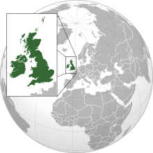
- نقشهای از جزایر بریتانیا و موقعیت آنها در اروپا
- بریتانیای کبیر
منابع[ویرایش]
- ↑ "the British Isles". téarma.ie – Dictionary of Irish Terms. Foras na Gaeilge and Dublin City University. Retrieved 18 Nov 2016.
the British Isles s pl (Tíreolaíocht · Geography; Polaitíocht · Politics; Stair · History; Logainmneacha " Ceantar/Réigiún · Placenames " Area/Region) Na hOileáin bhriontanacha
- ↑ University of Glasgow Department of Celtic
- ↑ Office of The President of Tynwald (PDF), archived from the original (PDF) on 2009-02-24
- ↑ "Règlement (1953) (Amendement) Sur L'importation et L'exportation D'animaux". States of Jersey. Archived from the original on 29 January 2016. Retrieved 2 February 2012.
- ↑ Country/Territory Index, Island Directory بایگانیشده در ۱۳ دسامبر ۲۰۱۸ توسط Wayback Machine, United Nations Environment Programme. Retrieved 9 August 2015.
Island Facts بایگانیشده در ۴ مارس ۲۰۱۶ توسط Wayback Machine, Isle of Man Government. Retrieved 9 August 2015.
According to the UNEP, the Channel Islands have a land area of 194 km², the Republic of Ireland has a land area of 70,282 km², and the United Kingdom has a land area of 244,111 km². According to the Isle of Man Government, the Isle of Man has a land area of 572 km². Therefore, the overall land area of the British Isles is 315,159 km² - ↑ "Great Britain's tallest mountain is taller - Ordnance Survey Blog". Ordnance Survey Blog (به انگلیسی). 2016-03-18. Retrieved 2018-09-09.
- ↑ "World Population Prospects 2017". Archived from the original on 27 September 2016. Retrieved 16 January 2019.
- ↑ "British Isles", Encyclopædia Britannica


 French
 Deutsch

