
 French
 Deutsch
Tourtour
Tourtour | |
|---|---|
 Overview of Tourtour | |
 Coat of arms | |
Location of Tourtour  | |
 Tourtour  Tourtour | |
| Coordinates: 43°35′25″N 6°18′11″E / 43.5903°N 6.3031°E | |
| Country | France |
| Region | Provence-Alpes-Côte d'Azur |
| Department | Var |
| Arrondissement | Brignoles |
| Canton | Flayosc |
| Government | |
| • Mayor (2020–2026) | Fabien Brieugne[1] |
| Area 1 | 28.69 km2 (11.08 sq mi) |
| Population (2021)[2] | 585 |
| • Density | 20/km2 (53/sq mi) |
| Time zone | UTC+01:00 (CET) |
| • Summer (DST) | UTC+02:00 (CEST) |
| INSEE/Postal code | 83139 /83690 |
| Elevation | 375–904 m (1,230–2,966 ft) (avg. 635 m or 2,083 ft) |
| 1 French Land Register data, which excludes lakes, ponds, glaciers > 1 km2 (0.386 sq mi or 247 acres) and river estuaries. | |
Tourtour (French pronunciation: [tuʁtuʁ]; Occitan: Tortor) is a commune in the Var department in the Provence-Alpes-Côte d'Azur region in southeastern France. It is a member of Les Plus Beaux Villages de France ("The most beautiful villages of France") association.
Geography[edit]
Called "the village in the sky of Provence" (le village dans le ciel de Provence), Tourtour overlooks a large part of Provence from the town of Fréjus along the Mediterranean coast in the east to the Montagne Sainte-Victoire, a favorite subject of the painter Paul Cézanne, in the west.
In popular culture[edit]
The Bastide de Tourtour, a local hotel, was prominently featured in the film Day of the Jackal and the 2010 ITV series "Monte Carlo or bust".
Sister cities[edit]
Gallery[edit]
- Sights of Tourtour
-
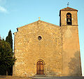 The Romanesque Saint-Denis Church
 -
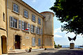 Tourtour town hall
 -
 Grimaldi tower


See also[edit]
References[edit]
- ^ "Répertoire national des élus: les maires" (in French). data.gouv.fr, Plateforme ouverte des données publiques françaises. 13 September 2022.
- ^ "Populations légales 2021". The National Institute of Statistics and Economic Studies. 28 December 2023.
External links[edit]
- Village de Tourtour
- (in German) Pictures Tourtour
| International | |
|---|---|
| National | |
| Geographic | |
This Var geographical article is a stub. You can help Wikipedia by expanding it. |