
 French
 Deutsch
Taysan
Taysan | |
|---|---|
| Municipality of Taysan | |
 Downtown | |
 Seal | |
 Map of Batangas with Taysan highlighted | |
OpenStreetMap  | |
.svg) Taysan Location within the Philippines | |
| Coordinates: 13°47′N 121°12′E / 13.78°N 121.2°E | |
| Country | Philippines |
| Region | Calabarzon |
| Province | Batangas |
| District | 4th district |
| Founded/Chartered | 1919 |
| Barangays | 20 (see Barangays) |
| Government | |
| • Type | Sangguniang Bayan |
| • Mayor | Edilberto T. Abaday |
| • Vice Mayor | Luis C. Favorito |
| • Representative | Lianda B. Bolilia |
| • Municipal Council | Members |
| • Electorate | 28,616 voters (2022) |
| Area | |
| • Total | 93.62 km2 (36.15 sq mi) |
| Elevation | 196 m (643 ft) |
| Highest elevation | 977 m (3,205 ft) |
| Lowest elevation | 31 m (102 ft) |
| Population (2020 census)[3] | |
| • Total | 40,146 |
| • Density | 430/km2 (1,100/sq mi) |
| • Households | 9,735 |
| Economy | |
| • Income class | 2nd municipal income class |
| • Poverty incidence | 11.77 |
| • Revenue | ₱ 187.5 million (2020) |
| • Assets | ₱ 525 million (2020) |
| • Expenditure | ₱ 166.2 million (2020) |
| • Liabilities | ₱ 173.1 million (2020) |
| Service provider | |
| • Electricity | Batangas 2 Electric Cooperative (BATELEC 2) |
| Time zone | UTC+8 (PST) |
| ZIP code | 4228 |
| PSGC | |
| IDD : area code | +63 (0)43 |
| Native languages | Tagalog |
Taysan, officially the Municipality of Taysan (Tagalog: Bayan ng Taysan), is a 2nd class municipality in the province of Batangas, Philippines. According to the 2020 census, it has a population of 40,146 people.[3]
Etymology[edit]
Taysan may have derived its name from the following Tagalog words:
- Atisan, which means "a place where atis abound nearing Lobo."[5]
- Tiis, which translates to "to bear with fortitude," as early natives experienced hardships during their entry and stay at the area due to its remote location accessible through many river crossings and dangerous trails, according to a folklore.[5] A traveler also shouted "Tiisan!" (Tagalog for endure) on the way to the area, sticking to it until it is called Taisan or Taysan.[6]
History[edit]
Taysan traces its origin to Mercedes, a barrio part of Rosario. It was later converted into a municipality known as Taysan, according to Manuel Sastron's 1895 publication Batangas y Su Provincia.[6] Lobo was consolidated with it in 1903[7] but was merged with Rosario in the same year. Taysan was officially made an independent municipality in 1919.[8]
Geography[edit]
Taysan is located at 13°47′N 121°12′E / 13.78°N 121.2°E.
According to the Philippine Statistics Authority, the municipality has a land area of 93.62 square kilometers (36.15 sq mi) [9] constituting 3.00% of the 3,119.75-square-kilometer (1,204.54 sq mi) total area of Batangas.
Taysan is bordered on the north by Rosario and Ibaan, east by a portion of Rosario, west by Batangas City, and south by Lobo.
Barangays[edit]
Taysan is politically subdivided into 20 barangays.[10] Each barangay consists of puroks and some have sitios.
| PSGC | Barangay | Population | ±% p.a. | |||
|---|---|---|---|---|---|---|
| 2020[3] | 2010[11] | |||||
| 041032001 | Bacao | 2.3% | 918 | 970 | −0.55% | |
| 041032002 | Bilogo | 5.6% | 2,252 | 2,070 | 0.85% | |
| 041032003 | Bukal | 3.9% | 1,554 | 1,448 | 0.71% | |
| 041032004 | Dagatan | 7.7% | 3,078 | 2,667 | 1.44% | |
| 041032005 | Guinhawa | 3.3% | 1,327 | 1,194 | 1.06% | |
| 041032006 | Laurel | 4.3% | 1,739 | 1,658 | 0.48% | |
| 041032007 | Mabayabas | 5.6% | 2,264 | 2,072 | 0.89% | |
| 041032008 | Mahanadiong | 4.8% | 1,908 | 1,741 | 0.92% | |
| 041032009 | Mapulo | 7.7% | 3,084 | 2,850 | 0.79% | |
| 041032010 | Mataas na Lupa | 3.6% | 1,452 | 1,540 | −0.59% | |
| 041032011 | Pag‑Asa | 6.1% | 2,468 | 2,293 | 0.74% | |
| 041032012 | Panghayaan | 3.2% | 1,286 | 1,230 | 0.45% | |
| 041032013 | Piña | 3.8% | 1,525 | 1,462 | 0.42% | |
| 041032014 | Pinagbayanan | 6.5% | 2,625 | 2,310 | 1.29% | |
| 041032015 | Poblacion East | 2.1% | 846 | 818 | 0.34% | |
| 041032016 | Poblacion West | 2.4% | 976 | 901 | 0.80% | |
| 041032017 | San Isidro | 6.4% | 2,581 | 2,401 | 0.73% | |
| 041032018 | San Marcelino | 4.5% | 1,807 | 1,700 | 0.61% | |
| 041032019 | Santo Niño | 6.2% | 2,501 | 2,303 | 0.83% | |
| 041032020 | Tilambo | 4.5% | 1,816 | 1,729 | 0.49% | |
| Total | 40,146 | 35,357 | 1.28% | |||
Climate[edit]
| Climate data for Taysan, Batangas | |||||||||||||
|---|---|---|---|---|---|---|---|---|---|---|---|---|---|
| Month | Jan | Feb | Mar | Apr | May | Jun | Jul | Aug | Sep | Oct | Nov | Dec | Year |
| Mean daily maximum °C (°F) | 26 (79) | 27 (81) | 29 (84) | 31 (88) | 31 (88) | 30 (86) | 29 (84) | 28 (82) | 28 (82) | 28 (82) | 28 (82) | 26 (79) | 28 (83) |
| Mean daily minimum °C (°F) | 20 (68) | 20 (68) | 20 (68) | 21 (70) | 23 (73) | 24 (75) | 24 (75) | 23 (73) | 23 (73) | 22 (72) | 22 (72) | 21 (70) | 22 (71) |
| Average precipitation mm (inches) | 52 (2.0) | 35 (1.4) | 27 (1.1) | 27 (1.1) | 82 (3.2) | 124 (4.9) | 163 (6.4) | 144 (5.7) | 145 (5.7) | 141 (5.6) | 100 (3.9) | 102 (4.0) | 1,142 (45) |
| Average rainy days | 12.0 | 8.1 | 8.8 | 9.7 | 17.9 | 22.6 | 26.2 | 24.5 | 24.6 | 22.0 | 16.7 | 14.9 | 208 |
| Source: Meteoblue[12] | |||||||||||||
Demographics[edit]
| Year | Pop. | ±% p.a. |
|---|---|---|
| 1903 | 3,386 | — |
| 1939 | 8,526 | +2.60% |
| 1948 | 10,318 | +2.14% |
| 1960 | 11,750 | +1.09% |
| 1970 | 14,999 | +2.47% |
| 1975 | 17,075 | +2.63% |
| 1980 | 19,370 | +2.55% |
| 1990 | 22,508 | +1.51% |
| 1995 | 26,504 | +3.11% |
| 2000 | 29,836 | +2.57% |
| 2007 | 33,454 | +1.59% |
| 2010 | 35,357 | +2.03% |
| 2015 | 38,007 | +1.39% |
| 2020 | 40,146 | +1.08% |
| Source: Philippine Statistics Authority[13][11][14][15] | ||
In the 2020 census, Taysan had a population of 40,146.[3] The population density was 430 inhabitants per square kilometer (1,100/sq mi).
Economy[edit]
Graphs are unavailable due to technical issues. There is more info on Phabricator and on MediaWiki.org. |
Gallery[edit]
-
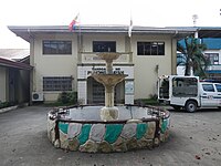 Municipal hall
 -
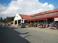 Public market
 -
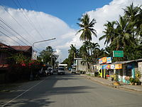 A street in town
 -
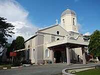 Nuestra Señora dela Merced Parish Church


References[edit]
- ^ Municipality of Taysan | (DILG)
- ^ "2015 Census of Population, Report No. 3 – Population, Land Area, and Population Density" (PDF). Philippine Statistics Authority. Quezon City, Philippines. August 2016. ISSN 0117-1453. Archived (PDF) from the original on May 25, 2021. Retrieved July 16, 2021.
- ^ a b c d Census of Population (2020). "Region IV-A (Calabarzon)". Total Population by Province, City, Municipality and Barangay. Philippine Statistics Authority. Retrieved 8 July 2021.
- ^ "PSA Releases the 2018 Municipal and City Level Poverty Estimates". Philippine Statistics Authority. 15 December 2021. Retrieved 22 January 2022.
- ^ a b "Taysan, Batangas History". Wow Batangas. August 22, 2012. Retrieved July 15, 2023.
- ^ a b Buhay Batangas (March 3, 2018). "Taysan's Relative Isolation from the Rest of Batangas in 1916". Batangas History, Culture and Folklore. Retrieved July 15, 2023.
- ^ Act No. 708 (28 March 1903), An Act Reducing Thirteen of the Municipalities in the Province of Batangas to Five, retrieved July 15, 2023
- ^ "Executive Summary" (PDF). Commission on Audit. 2021.
- ^ "Province: Batangas". PSGC Interactive. Quezon City, Philippines: Philippine Statistics Authority. Retrieved 12 November 2016.
- ^ "Municipal: Taysan". PSGC Interactive. Quezon City, Philippines: Philippine Statistics Authority. Retrieved 8 January 2016.
- ^ a b Census of Population and Housing (2010). "Region IV-A (Calabarzon)" (PDF). Total Population by Province, City, Municipality and Barangay. National Statistics Office. Retrieved 29 June 2016.
- ^ "Taysan: Average Temperatures and Rainfall". Meteoblue. Retrieved 5 May 2020.
- ^ Census of Population (2015). "Region IV-A (Calabarzon)". Total Population by Province, City, Municipality and Barangay. Philippine Statistics Authority. Retrieved 20 June 2016.
- ^ Censuses of Population (1903–2007). "Region IV-A (Calabarzon)". Table 1. Population Enumerated in Various Censuses by Province/Highly Urbanized City: 1903 to 2007. National Statistics Office.
{{cite encyclopedia}}: CS1 maint: numeric names: authors list (link) - ^ "Province of Batangas". Municipality Population Data. Local Water Utilities Administration Research Division. Retrieved 17 December 2016.
- ^ "Poverty incidence (PI):". Philippine Statistics Authority. Retrieved December 28, 2020.
- ^ "Estimation of Local Poverty in the Philippines" (PDF). Philippine Statistics Authority. 29 November 2005.
- ^ "2003 City and Municipal Level Poverty Estimates" (PDF). Philippine Statistics Authority. 23 March 2009.
- ^ "City and Municipal Level Poverty Estimates; 2006 and 2009" (PDF). Philippine Statistics Authority. 3 August 2012.
- ^ "2012 Municipal and City Level Poverty Estimates" (PDF). Philippine Statistics Authority. 31 May 2016.
- ^ "Municipal and City Level Small Area Poverty Estimates; 2009, 2012 and 2015". Philippine Statistics Authority. 10 July 2019.
- ^ "PSA Releases the 2018 Municipal and City Level Poverty Estimates". Philippine Statistics Authority. 15 December 2021. Retrieved 22 January 2022.
External links[edit]
Places adjacent to Taysan | ||||||||||||||||
|---|---|---|---|---|---|---|---|---|---|---|---|---|---|---|---|---|
| ||||||||||||||||
| Component cities | |
|---|---|
| Municipalities | |
This article about a location in Calabarzon region is a stub. You can help Wikipedia by expanding it. |