
 French
 Deutsch
Qeshm Island
Native name: قشم | |
|---|---|
 Qeshm from space, August 2000 | |
 Map of Qeshm Island and surroundings, in French | |
 Qeshm Location of Queshm Island in Iran  Qeshm Location of Queshm Island in the Persian Gulf | |
| Geography | |
| Location | Strait of Hormuz |
| Coordinates | 26°41′43″N 55°37′06″E / 26.69528°N 55.61833°E |
| Area | 1,491 km2 (576 sq mi) |
| Length | 135 km (83.9 mi) |
| Width | 40 km (25 mi) |
| Administration | |
| Province | Hormozgān |
| County | Qeshm |
| Bakhsh | Central |
| Largest settlement | Qeshm (pop. 40,678) |
| Demographics | |
| Population | 148,993 (2016) |
| Pop. density | 67.07/km2 (173.71/sq mi) |
Qeshm (Persian: قشم, Persian pronunciation: [ɢeʃm]) is an arrow-shaped Iranian island in the Strait of Hormuz, separated from the mainland by the Clarence Strait/Khuran in the Persian Gulf (26°50′N 56°0′E / 26.833°N 56.000°E). Qeshm is the largest island in Iran, and the largest in the Persian Gulf.
Geography[edit]

Qeshm Island is located a few kilometers off the southern Iran shoreline (Persian Gulf), opposite the port cities of Bandar Abbas and Bandar Khamir. The island, which hosts a 300-square-kilometre (116-square-mile) free zone jurisdiction, is 135 km long and lies strategically in the Strait of Hormuz, just 60 kilometres (37 miles) from the Omani port of Khasab and about 180 kilometres (112 miles) from the UAE's Port Rashid. At its widest point near the center, the island spans 40 kilometres (25 miles). At its narrowest point, the island spans 9.4 kilometres (5.8 miles). The island has a surface area of 1,491 square kilometres (576 square miles) and is almost twice the size of Bahrain. The city of Qeshm, located at the easternmost point of the island, is 22 kilometres (14 miles) from Bandar Abbas, while the closest point of the island is but two kilometres (1 mile) from the mainland.
The average temperature on the island is approximately 27 °C (81 °F). The warmest months are June through August, and the coldest from October to January. The average rainfall is 183.2 mm (7+3⁄16 in).
The island, comprising 59 towns and villages, had a population of 117,774 at the time of the 2011 Census. The local population is engaged in fishing, dhow construction, trade and services. An additional 30,000 are administrative or industrial workers or students.
Plans have also been made to build a bridge to connect Qeshm with mainland Iran.[1][2]
Qeshm Island has multiple attractions to attract more domestic and foreign tourists.[3]
Namakdan Salt Cave[edit]
At 6.58km long, Namakdan Salt Cave is the longest known salt cave in the world. Both salt and sulphur were mined here traditionally ('namak' is a Farsi word for salt) and it now forms the key geosite within the Qeshm Island UNESCO Global Geopark. The cave is formed within a large salt diapir formed of a succession of strata which dates from the late Proterozoic. It is also a candidate site for inscription on the list of World Heritage Sites.[4] The locality was included within a list of the 'First 100 IUGS Geological Heritage Sites' published in October 2022 on account of its significance to our understanding of tectonics and active geological processes.[5]
History[edit]
.jpg)
The earliest evidence of human presence at Qeshm dates back to the Paleolithic Period. Paleolithic stone tools have been found at Bam-e Qeshm.[6] Historical records concerning the Qeshm island date far back into the pre-Islamic era. Names such as Qeshm, Keshm, Kish and Tunb mark the lengthy stay of Ilamids in the area, several centuries BC. It is, apparently, the island called Alexandria or Aracia by Ptolemy (Book 6, Chap. IV), in the 2nd century CE and Alexandria by Ammianus Marcellinus (xxiii.6.42) in the 4th century. On account of its strategic geopolitical situation near the mouth of the Persian Gulf, it has been frequently attacked by invaders including Ilamids (Elamites), Umayyads, and Abbasids as well as the Portuguese, English, and Dutch. Under Sassanian rule the island was called Abarkawan, and was part of the Ardashir-Khwarrah administrative division.[7] According to historical records, Qeshm Island has been famous as a trade and navigation center. Its economy flourished during the Dailamite and Buyid eras, as trade vessels sailed between Qeshm Island and China, India, and Africa.
Explorer William Baffin was mortally wounded on Qeshm in 1622 during a battle against Portuguese forces who occupied the fort, known to the English as "Forte de Queixome".
Qeshm is also a supposed site of the Garden of Eden according to Cassell's Bible.[8]
Iran Air Flight 655[edit]
On 3 July 1988, a civilian Iran Air Airbus A300 (Iran Air Flight 655) was shot down by a United States Navy guided missile cruiser USS Vincennes just south of the island, killing all 290 people aboard.[9] The wreckage crashed 2.5 kilometers off Qeshm's southern coast.
Economy[edit]
Fishing is a leading occupation practiced by the inhabitants of the island. On what little cultivated land there is, dates and melons are grown. Salt is mined on the southeastern coast. Qeshm is famous for its wide range of ecotourist attractions such as the Hara marine forests. According to environmentalists, about 1.5% of the world birds and 25% of Iran's native birds annually migrate to the forests, which are the first national geo park in Iran. An ancient Portuguese fort, historic mosques, the Seyyed Mozaffar and Bibi Maryam shrines, and various ponds and mangrove forests are among the tourism attractions in the island, which lays across the azure waters of the Persian Gulf. Several domes, salty caves, the preserved area in Shibderaz Village where Hawksbill turtles hatch, as well as numerous docks and wharfs are among the tourist potentials of the island. The Nazz Islands are located at the south wing of Qeshm Island. Oysters, corals, colorful fishes and sea birds in these islands attract many tourists. It is possible to walk toward the island on soft and wet gravel through a gravel connection way between these islands and Qeshm at the time of the ebb.
-
 Naaz Islands, sea bed at low tide
 -
 Sea bed at Naaz Islands
 -
 Oysters in the holes of the Sea bed, Naaz Islands
 -
 Dolphins in the strait between Qeshm and Hengam Island.
 -
 Qeshm
Qeshm

.jpg)
.jpg)
.jpg)
.jpg)
In the 1st ten-year plan, in note 19, the law provided for the creation of free trade zones and three locations were identified as such in the year 1991. They were Kish Island, Qeshm Island and Chabahar. In the year 1369 in the Iranian Solar Hijri calendar, equivalent to 1991 in the Gregorian calendar, the island was transformed into a "Trade and Industrial Free Area" with the goal of creating the largest Free Area between Europe and the Far East.[10] To that end, Qeshm Island was granted considerable leeway to set its own policies, independent of the central government, which had often been seen as an impediment to growth in many sectors of the economy. However, the Island retains the advantages associated with its connection to the mainland, including the rights to explore and develop oil and gas opportunities.
-
-
 Chahkouh Valley at Qeshm Island
 -
 Stars Valley at Qeshm Island
 -
 A tourist running on the island beach
 -

-
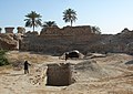
 Portuguese castle exterior
 -
 Portuguese castle interior
 -
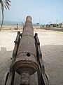 One of the cannons of Qeshm Portuguese castle
 -

-
 Qeshm International Airport - 2019
 -
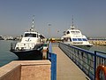 Shahid Zakeri Wharf


_003.jpg)
.jpg)
.jpg)


Qeshm Island underground military facility[edit]
On 20 January 2012, OSGEOINT[clarification needed] established the completion of an underground military facility at Qeshm island which accordingly could house Iran's Ghadir-Nahang class submarines.[11]
Economy, culture, and education[edit]
- Qeshm Institute of Higher Education
- Islamic Azad University of Medical Science Qeshm International Branch
Visas[edit]
Holders of normal passports travelling as tourists can enter Qeshm without a visa with maximum stay of 30 days (extendable), as of December 2017.[12][13]
Admission is refused to holders of passports or travel documents containing an Israeli visa or stamp or any data showing that visitor has been to Israel or indication of any connection with the state of Israel during the last 12 months.[14]
See also[edit]
- 2005 Qeshm earthquake
- Ardashir-Khwarrah
- Bandar Lengeh
- Hormozgan
- Qeshm Air
- Qeshm International Airport
References[edit]
- ^ "Austrians to Construct Persian Gulf Bridge to Connect Qeshm Island to the Main Island". payvand.com. Retrieved 2016-10-05.
- ^ "Qeshm – Dictionary definition of Qeshm | Encyclopedia.com: FREE online dictionary". www.encyclopedia.com. Retrieved 2016-10-05.
- ^ "Qeshm Island and its tourist attractions". IFPNews.com. Retrieved 2016-10-05.
- ^ "Namakdan Salt Cave". IUGS International Commission on Geoheritage. IUGS. Retrieved 2 November 2022.
- ^ "Namakadan Salt Cave, Iran" (PDF). IUGS International Commission on Geoheritage. IUGS. Retrieved 2 November 2022.
- ^ "Iranian Archaeologists Uncover Paleolithic Stone Tools on Qeshm Island – Tasnim News Agency". Tasnim News Agency. Retrieved 2018-07-09.
- ^ Hinds, Martin (1984). "The First Arab Conquests in Fārs". Iran. 22: 39–53. doi:10.2307/4299735. JSTOR 4299735. S2CID 194982986.
- ^ LTD, Kaspid. "Qeshm Island". www.arian-tour.com. Archived from the original on 2017-09-02. Retrieved 2016-08-26.
- ^ "Iran Air flight 655 | Background, Events, Investigation, & Facts". Encyclopedia Britannica.
- ^ Qeshm Island Archived July 4, 2008, at the Wayback Machine, Qeshm Energy International
- ^ Iran: Underground Naval Base at Qeshm Complete. Published by: OSGEOINT. OSGEOINT
- ^ "مزایای ثبت شرکت در مناطق آزاد". companyregister.ir.
- ^ "No visa required for Iran". June 30, 2015.
- ^ Visa information on the site of IRI Embassy in Moscow
Further reading[edit]
- Speak the Wind (Mack, 2021; photographs by Hoda Afshar; essay by Michael Taussig[1]) This work documents the landscapes and people of the islands of Hormuz, Qeshm, and Hengam, in the Persian Gulf off the south coast of Iran.[2][3] Afshar got to know some of the people there, travelling there frequently over the years, and they told her about the history of the place. She said that "their narrations led the project", and she explores "the idea of being possessed by history, and in this context, the history of slavery and cruelty”.[4]
External links[edit]
- About Qeshm Island (Qeshm Island Global Geopark)
| Capital | |||||||||||||||||||||||||||||||||
|---|---|---|---|---|---|---|---|---|---|---|---|---|---|---|---|---|---|---|---|---|---|---|---|---|---|---|---|---|---|---|---|---|---|
| Districts |
| ||||||||||||||||||||||||||||||||
Hormozgan Province, Iran | |||||||||||||||||||||||||
|---|---|---|---|---|---|---|---|---|---|---|---|---|---|---|---|---|---|---|---|---|---|---|---|---|---|
| Capital |  | ||||||||||||||||||||||||
| Counties and cities |
| ||||||||||||||||||||||||
| Sights |
| ||||||||||||||||||||||||
| populated places | |||||||||||||||||||||||||
| See also | |||||||||||||||||||||||||
|  | |||||||||||||||||||||||||||||||||||||||||||||||||||||||||||||||||||||||
|
| ||||||||||||||||||||||||||||||||||||||||||||||||||||||||||||||||||||||||
| ||||||||||||||||||||||||||||||||||||||||||||||||||||||||||||||||||||||||
| ||||||||||||||||||||||||||||||||||||||||||||||||||||||||||||||||||||||||
| ||||||||||||||||||||||||||||||||||||||||||||||||||||||||||||||||||||||||
| ||||||||||||||||||||||||||||||||||||||||||||||||||||||||||||||||||||||||
| International | |
|---|---|
| National | |
| Geographic | |
- ^ Afshar, Hoda; Taussig, Michael (2021). Speak the Wind. Photographs by Hoda Afhsar; essay by Michael Taussig. London: Mack. ISBN 978-1-913620-18-9.
- ^ Boetker-Smith, Daniel; Afshar, Hoda. "Speak the Wind - Book review". LensCulture. Photographs by Hoda Afshar. Retrieved 14 February 2022.
- ^ Colberg, Jörg (16 August 2021). "Speak The Wind". Conscientious Photography Magazine. Retrieved 14 February 2022.
- ^ Grieve, Michael (19 July 2021). "Hoda Afshar captures the wind and rituals of the islands in the Strait of Hormuz". 1854 Photography. Retrieved 14 February 2022.