
 French
 Deutsch
Monor, Bistrița-Năsăud
Monor | |
|---|---|
.jpg) Monor town hall | |
 Location in Bistrița-Năsăud County | |
 Monor Location in Romania | |
| Coordinates: 46°58′N 24°42′E / 46.967°N 24.700°E | |
| Country | Romania |
| County | Bistrița-Năsăud |
| Government | |
| • Mayor (2020–2024) | Ioan Cira (PSD) |
| Area | 52.98 km2 (20.46 sq mi) |
| Elevation | 453 m (1,486 ft) |
| Population (2021-12-01)[1] | 1,231 |
| • Density | 23/km2 (60/sq mi) |
| Time zone | EET/EEST (UTC+2/+3) |
| Postal code | 427175 |
| Vehicle reg. | BN |
| Website | www |
Monor (Hungarian: Monorfalva) is a commune in Bistrița-Năsăud County, Transylvania, Romania. It is composed of two villages, Gledin (Gledény) and Monor.
The commune is situated on the Transylvanian Plateau, at an altitude of 453 m (1,486 ft). It is located in the southern part of the county, 31 km (19 mi) southeast of the county seat, Bistrița, on the border with Mureș County.
Monor is crossed by county road DJ154, which starts in Bistrița and ends in Reghin. The route of the Via Transilvanica long-distance trail passes through both villages.[2]
See also[edit]
References[edit]
- ^ "Populaţia rezidentă după grupa de vârstă, pe județe și municipii, orașe, comune, la 1 decembrie 2021" (XLS). National Institute of Statistics.
- ^ "Highlands | Via Transilvanica". www.viatransilvanica.com. Retrieved 2023-08-10.
-
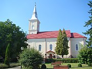 Orthodox church in Monor
 -
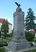 World War memorial
.jpg)
.jpg)

This Bistrița-Năsăud County location article is a stub. You can help Wikipedia by expanding it. |