
 French
 Deutsch
List of schools in Central Queensland
This is a list of schools in the Central Queensland region of Queensland, Australia, and includes schools in Central West Queensland. The region is centred on the coastal cities of Rockhampton and Gladstone, and the inland towns of Emerald, Longreach and Barcaldine. It includes the following local government areas:
- Shire of Banana
- Shire of Barcaldine
- Shire of Barcoo
- Blackall-Tambo Region
- Shire of Boulia
- Central Highlands Region
- Shire of Diamantina
- Gladstone Region
- Isaac Region
- Shire of Livingstone
- Shire of Longreach
- Rockhampton Region
- Aboriginal Shire of Woorabinda
- Shire of Winton
Prior to 2015, the Queensland education system consisted of primary schools, which accommodated students from Kindergarten to Year 7 (ages 5–13), and high schools, which accommodate students from Years 8 to 12 (ages 12–18). However, from 2015, Year 7 became the first year of high school.[1]
State schools[edit]
State primary schools[edit]
| Name | Suburb | LGA | Opened | Coords | Notes |
|---|---|---|---|---|---|
| Agnes Water State School | Agnes Water | Gladstone | 1990 | 24°12′51″S 151°54′37″E / 24.2143°S 151.9102°E | 1 Donohue Drive |
| Allenstown State School | Allenstown | Rockhampton | 1877 | 23°23′31″S 150°30′09″E / 23.3919°S 150.5026°E | 13–33 Upper Dawson Road. Listed on the Queensland Heritage Register. |
| Alpha State School | Alpha | Barcaldine | 1886 | 23°39′03″S 146°38′32″E / 23.6507°S 146.6422°E | 11 Milton Street |
| Ambrose State School | Ambrose | Gladstone | 1914 | 23°47′11″S 150°55′18″E / 23.7864°S 150.9218°E | 39 Gentle Annie Road |
| Anakie State School | Anakie Siding | Central Highlands | 1885 | 23°33′14″S 147°44′45″E / 23.5540°S 147.7458°E | 1 School Lane[2] |
| Aramac State School | Aramac | Barcaldine | 1878 | 22°58′28″S 145°14′33″E / 22.9744°S 145.2426°E | 69 Porter Street. Listed on the Queensland Heritage Register. |
| Arcadia Valley State School | Arcadia Valley | Central Highlands | 1975 | 25°15′18″S 148°49′15″E / 25.2550°S 148.8208°E | 4831 Arcadia Valley Road |
| Bajool State School | Bajool | Rockhampton | 1888 | 23°39′08″S 150°38′48″E / 23.6523°S 150.6467°E | 54–60 Toonda Street |
| Banana State School | Banana | Banana | 1871 | 24°28′09″S 150°07′52″E / 24.469134°S 150.131069°E | 36 Bramston Street |
| Baralaba State School | Baralaba | Banana | 1918 | 24°10′52″S 149°48′35″E / 24.1810°S 149.8097°E | P–10. 1 Power Street. |
| Bauhinia State School | Bauhinia | Central Highlands | 1967 | 24°34′00″S 149°17′46″E / 24.5666°S 149.2960°E | 11559 Fitzroy Development Road |
| Bedourie State School | Bedourie | Diamantina | 1960 | 24°21′37″S 139°28′17″E / 24.3603°S 139.4713°E | 3 Timor Street |
| Benaraby State School | Benaraby | Gladstone | 1886 | 24°00′13″S 151°19′26″E / 24.0037°S 151.3238°E | 17 O'Connor Road |
| Berserker Street State School | Berserker | Rockhampton | 1917 | 23°21′55″S 150°31′48″E / 23.3654°S 150.5299°E | 128–140 Berserker Street. Separate Infants' School 1957–1994. Listed on the Queensland Heritage Register. |
| Biloela State School | Biloela | Banana | 1925 | ||
| Birdsville State School | Birdsville | Diamantina | 1899 | ||
| Blackwater North State School | Blackwater | Central Highlands | 1979 | ||
| Blackwater State School | Blackwater | Central Highlands | 1877 | ||
| Bluff State School | Bluff | Central Highlands | 1907 | ||
| Bororen State School | Bororen | Gladstone | 1900 | ||
| Bouldercombe State School | Bouldercombe | Rockhampton | 1871 | ||
| Boulia State School | Boulia | Boulia | 1889 | ||
| Boyne Island State School | Boyne Island | Gladstone | 1953 | ||
| Builyan State School | Builyan | Gladstone | 1922 | ||
| Byfield State School | Byfield | Livingstone | 1923 | ||
| Calliope State School | Calliope | Gladstone | 1872 | ||
| Capella State School | Capella | Central Highlands | 1883 | ||
| Carmila State School | Carmila | Isaac | 1923 | ||
| Cawarral State School | Cawarral | Livingstone | 1874 | ||
| Clarke Creek State School | Clarke Creek | Isaac | 1971 | ||
| Clermont State School | Clermont | Isaac | 1867 | ||
| Clinton State School | Clinton | Gladstone | 1974 | ||
| Comet State School | Comet | Central Highlands | 1877 | ||
| Coowonga State School | Coowonga | Livingstone | 1897 | ||
| Coppabella State School | Coppabella | Isaac | 1980 | ||
| Crescent Lagoon State School | West Rockhampton | Rockhampton | 1896 | ||
| Denison State School | Emerald | Central Highlands | 1997 | 23°31′56″S 148°09′04″E / 23.5322°S 148.1512°E | 16 Gray Street |
| Depot Hill State School | Depot Hill | Rockhampton | 1920 | ||
| Dingo State School | Dingo | Central Highlands | 1876 | ||
| Duaringa State School | Duaringa | Central Highlands | 1879 | ||
| Dysart State School | Dysart | Isaac | 1973 | ||
| Emerald North State School | Emerald | Central Highlands | 1980 | ||
| Emerald State School | Emerald | Central Highlands | 1879 | ||
| Emu Park State School | Emu Park | Livingstone | 1890 | ||
| Farnborough State School | Farnborough | Livingstone | 1903 | ||
| Frenchville State School | Frenchville | Rockhampton | 1900 | ||
| Gindie State School | Gindie | Central Highlands | 1897 | ||
| Gladstone Central State School | Gladstone Central | Gladstone | 1861 | ||
| Gladstone South State School | South Gladstone | Gladstone | 1898 | ||
| Gladstone West State School | West Gladstone | Gladstone | 1966 | ||
| Glenmore State School | Kawana | Rockhampton | 1889 | ||
| Gogango State School | Gogango | Rockhampton | 1974 | 23°39′53″S 150°02′40″E / 23.6647°S 150.0444°E | 10 Wills Street |
| Goovigen State School | Goovigen | Banana | 1926 | ||
| Gracemere State School | Gracemere | Rockhampton | 1871 | ||
| Ilfracombe State School | Ilfracombe | Longreach | 1893 | 23°29′20″S 144°30′17″E / 23.4890°S 144.5046°E | 20 McMaster Drive |
| Isisford State School | Isisford | Longreach | 1881 | ||
| Jambin State School | Jambin | Banana | 1929 | ||
| Jericho State School | Jericho | Barcaldine | 1888 | ||
| Jundah State School | Jundah | Barcoo | 1900 | ||
| Keppel Sands State School | Keppel Sands | Livingstone | 1893 | ||
| Kilcummin State School | Kilcummin | Isaac | 1959 | ||
| Kin Kora State School | Kin Kora | Gladstone | 1981 | Earlier school closed 1963 | |
| Lakes Creek State School | Lakes Creek | Rockhampton | 1872 | ||
| Lochington State School | Lochington | Central Highlands | 1961 | ||
| Longreach State School | Longreach | Longreach | 1893 | ||
| Lowmead State School | Lowmead | Gladstone | 1908 | Closed 1975–1978 | |
| Mackenzie River State School | Mackenzie River | Isaac | 1973 | ||
| Marlborough State School | Marlborough | Livingstone | 1917 | ||
| Marmor State School | Marmor | Rockhampton | 1906 | ||
| Milman State School | Milman | Livingstone | 1913 | ||
| Miriam Vale State School | Miriam Vale | Gladstone | 1897 | P–10 | |
| Mistake Creek State School | Mistake Creek | Isaac | 1983 | ||
| Moranbah East State School | Moranbah | Isaac | 1981 | ||
| Moranbah State School | Moranbah | Isaac | 1971 | ||
| Mount Archer State School | Koongal | Rockhampton | 1982 | 23°21′29″S 150°32′44″E / 23.3581°S 150.5456°E | 242 Thozet Road |
| Mount Larcom State School | Mount Larcom | Gladstone | 1882 | P–10 | |
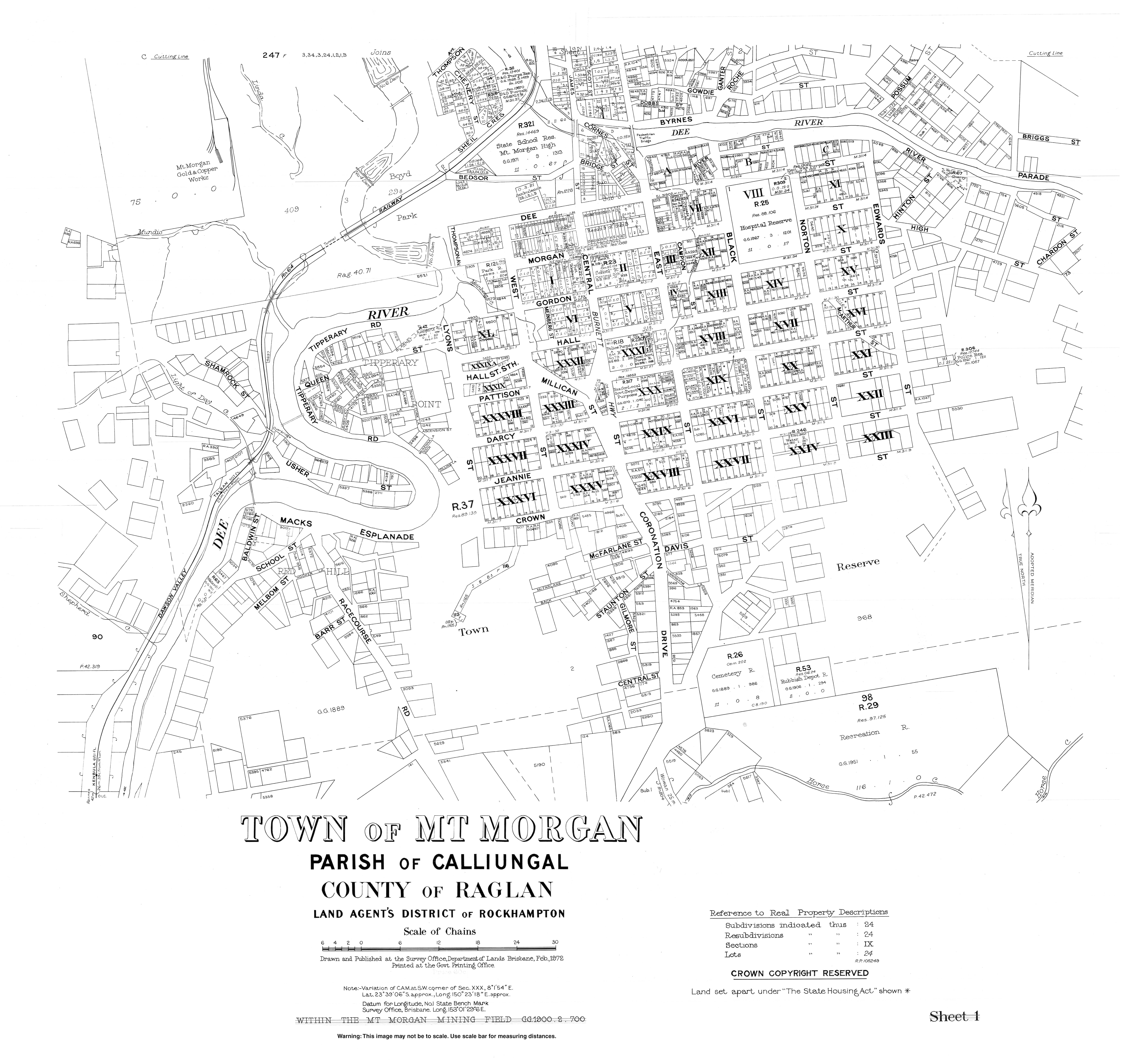
| Mount Morgan Central State School | Mount Morgan | Rockhampton | 1887 | Listed on the Queensland Heritage Register | |
| Mount Murchison State School | Mount Murchison | Banana | 1935 | ||
| Moura State School | Moura | Banana | 1940 | ||
| Muttaburra State School | Muttaburra | Barcaldine | 1884 | ||
| Nagoorin State School | Nagoorin | Gladstone | 1915 | 24°21′06″S 151°18′00″E / 24.3516°S 151.2999°E | 2 Ubobo Street |
| Nebo State School | Nebo | Isaac | 1874 | ||
| Orion State School | Orion | Central Highlands | 1964 | ||
| Park Avenue State School | Park Avenue | Rockhampton | 1901 | ||
| Parkhurst State School | Parkhurst | Rockhampton | 1900 | ||
| Port Curtis Road State School | Port Curtis | Rockhampton | 1875 | ||
| Prospect Creek State School | Prospect Creek | Banana | 1935 | 24°25′16″S 150°25′45″E / 24.4211°S 150.4293°E | Originally opened as Torsdale Farm Provisional School. Changed name in 1944. Located at 12935 Dawson Highway.[3] |
| Ridgelands State School | Ridgelands | Rockhampton | 1921 | ||
| Rolleston State School | Rolleston | Central Highlands | 1871 | ||
| Springsure State School | Springsure | Central Highlands | 1870 | 24°06′57″S 148°05′19″E / 24.1157°S 148.0885°E | Prep–10 school at 55 Eclipse Street.[4] |
| St Lawrence State School | St Lawrence | Isaac | 1871 | ||
| Stanwell State School | Stanwell | Rockhampton | 1873 | ||
| Stonehenge State School | Stonehenge | Barcoo | 1900 | ||
| Tambo State School | Tambo | Blackall-Tambo | 1876 | 24°53′04″S 146°15′13″E / 24.8845°S 146.2537°E | 20 Mitchell Street |
| Tannum Sands State School | Tannum Sands | Gladstone | 1983 | ||
| Taranganba State School | Taranganba | Livingstone | 1993 | 23°09′17″S 150°45′15″E / 23.1546°S 150.7542°E | Taranganba Road.[5] |
| Taroom State School | Taroom | Banana | 1871 | ||
| Thangool State School | Thangool | Banana | 1927 | P–10 | |
| The Caves State School | The Caves | Livingstone | 1904 | 23°10′36″S 150°27′33″E / 23.1767°S 150.4593°E | Located at 1 Barmoya Road.[6] |
| The Hall State School | Rockhampton City | Rockhampton | 1910 | Girls' and Infants' until 1986 | |
| Theodore State School | Theodore | Banana | 1924 | ||
| Tieri State School | Tieri | Central Highlands | 1983 | 23°01′49″S 148°20′39″E / 23.0304°S 148.3441°E | 1 Bottlebrush Lane |
| Tresswell State School | Nandowrie | Central Highlands | 1971 | ||
| Ubobo State School | Ubobo | Gladstone | 1927 | ||
| Urandangi State School | Urandangi | Boulia | 1994 | ||
| Valkyrie State School | Valkyrie | Isaac | 1974 | ||
| Waraburra State School | Gracemere | Rockhampton | 1987 | ||
| Wartburg State School | Wartburg | Gladstone | 1913 | ||
| Westwood State School | Westwood | Rockhampton | 1872 | ||
| Windorah State School | Windorah | Barcoo | 1888 | ||
| Woorabinda State School | Woorabinda | Woorabinda | 1928 | ||
| Wowan State School | Wowan | Banana | 1900 | ||
| Yarwun State School | Yarwun | Gladstone | 1906 | ||
| Yeppoon State School | Yeppoon | Livingstone | 1885-1957 | 23°07′48″S 150°44′46″E / 23.1299°S 150.7461°E | 29 Queen Street, listed on the Queensland Heritage Register[7] |
| 1957 | 23°07′31″S 150°44′16″E / 23.1253°S 150.7379°E | 14–16 Tucker Street, listed on the Queensland Heritage Register[8] |
State high schools and colleges[edit]
Other state schools[edit]
This includes special schools (schools for disabled children) and schools for specific purposes.
| Name | Suburb | LGA | Opened | Notes |
|---|---|---|---|---|
| Capricornia School of Distance Education | Kawana | Rockhampton | 1993 | Distance education centre |
| Longreach School of Distance Education | Longreach | Longreach | 1987 | Distance education centre |
| Rockhampton North Special School | Frenchville | Rockhampton | 1977 | On site of previous SS |
| Rockhampton Special School | Rockhampton City | Rockhampton | 1976 | |
| Rosella Park School | Gladstone | Gladstone | 1971 |
Defunct state schools[edit]
| Name | Suburb | LGA | Opened | Closed | Coords | Notes |
|---|---|---|---|---|---|---|
| Alsace State School | Alsace | Central Highlands | 1977 | 1987 | ||
| Alton Downs State School | Alton Downs | Rockhampton | 1890 | 1964 | 23°18′26″S 150°23′13″E / 23.3071°S 150.3869°E | Located at 1247 Ridgelands Road.[10][11] |
| Arthur's Creek State School | Baffle Creek | Gladstone | c1910 | c1936 | See Baffle Creek State School below | |
| Baffle Creek State School | Baffle Creek | Gladstone | 1955 | 1965 | There was an earlier school known as Baffle Creek State School which changed name to Arthur's Creek State School. It existed from approximately 1910–1936.[12] | |
| Bariveloe State School | Bariveloe (now in Colosseum) | Gladstone | 1927 | 1947 | approx 24°25′28″S 151°31′29″E / 24.4244°S 151.5246°E | Located on Bariveloe Road just south of Colosseum Creek.[13][11] |
| Barmoya East State School | Barmoya | Livingstone | 1911 | 1969 | 23°08′41″S 150°32′38″E / 23.14461°S 150.54377°E | Opened 1911 as Barmoya Settlement State School, renamed 1935 Barmoya East State School.[14] Located at 9 C H Barretts Road (corner of East Barmoya Road.[15] |
| Bathampton State School | Bathampton (now in Clermont) | Central Highlands | 1891 | 1950 | [16] | |
| Berserker Street State Infants School | Berserker | Rockhampton | 1957 | 1994 | Merged into Berserker Street State School | |
| Blair Athol State School | Blair Athol | Isaac | 1893 | 1974 | ||
| Bogantungan State School | Bogantungan | Central Highlands | 1883 | 1972 | 23°39′00″S 147°17′15″E / 23.6501°S 147.2875°E | Located on the west side of Jackson Street.[17] |
| Boolburra State School | Boolburra | Central Highlands | 1874 | 1926 | 23°44′06″S 149°47′00″E / 23.73487°S 149.78337°E | The school reserve of 6 acres 1 rood 10 perches (2.55 ha) was proclaimed in 1883, just north of the Boolburra railway station bounded by Station Road, Dawson Road, and Thomas Street.[18][19][20] |
| Bowman State School | Bowman (now in Ogmore) | Livingstone | 1921 | 1926 | Opened as Styx Coal Mine Provisional School. In 1923 reopened at a new location as Bowman State School. | |
| Bracewell State School | Bracewell | Gladstone | 1915 | 2000 | 23°55′44″S 150°53′54″E / 23.9290°S 150.8983°E | Located at 1444 Mount Larcom Bracewell Road.[21][22] |
| Braeside State School | Braeside (now in Strathfield) | Isaac | 1923 | 1967 | [23] | |
| Buckland State School | Buckland | Central Highlands | 1909 | 1959 | ||
| Bunerba State School | Bunerba (now in Dululu) | Banana | 1922 | 1996 | 23°52′29″S 150°17′52″E / 23.8748°S 150.2979°E | Located at 88 Bunerba School Road.[24][25] |
| Buneru State School | Wowan | Banana | 1918 | 1934 | 23°58′06″S 150°09′51″E / 23.96828°S 150.16419°E | Located on the south-western corner of Portion 100 on the (now) Leichhardt Highway.[26][27] |
| 1934 | 1962 | 23°57′27″S 150°08′57″E / 23.9576°S 150.1492°E | Following flooding in 1928,[28][29] the decision was made to relocate and enlarge the school,[30][31] at the south-west corner of Buneru Road and Buneru School Road.[32][33] | |||
| Bungundarra State School | Bungundarra | Livingstone | 1912 | 1950 | approx 23°03′36″S 150°39′14″E / 23.06011°S 150.65378°E | Located on the western side of Bungundarra Road.[34] |
| Butlerville State School | Mount Larcom | Gladstone | 1918 | 1927 | 23°45′09″S 151°01′57″E / 23.7525°S 151.0324°E | Located on a five-acre (2.0 ha) site on the western side of a bend in The Narrows Road.[35][36] |
| Callide State School | Callide (now in Jambin) | Banana | 1925 | 1971 | 24°18′04″S 150°27′32″E / 24.3012°S 150.4588°E | Located on Callide Road.[37] Although it is within the town of Callide, it is within the present-day boundaries of the neighbouring locality of Jambin.[38] |
| Calliope Station State School | Mount Alma | Gladstone | 1912 | 1956 | 24°01′50″S 150°57′45″E / 24.0306°S 150.9624°E | Located at 44 Galloway Plains Road.[39] |
| Calliungal North State School | Baree | Rockhampton | 1904 | 1971 | 23°36′47″S 150°23′29″E / 23.6130°S 150.39134°E | Also known unofficially as North Culliungal State School and Baree State School, it opened in April 1904, closing in 1929. In 1933 it reopened, closing finally in 1971. It was at 3–5 Calliungal Road.[40][41][42] |
| Calmorin State School | Ridgelands | Rockhampton | 1921 | 1963 | Originally opened as Ridgelands Provisional School, renamed Calmorin State School in 1924.[43] | |
| Calvale State School | Valentine Plains | Banana | 1940 | 1956 | approx 24°22′30″S 150°37′42″E / 24.3749°S 150.6284°E | Located on Calvale Road.[44] |
| Cardbeign State School | Cairdbeign | Central Highlands | circa 1894 | circa 1931 | 24°13′32″S 148°06′17″E / 24.2255°S 148.1047°E | Located on Dalmally Road.[45] Note the variant spelling. |
| Carmila West State School | Carmila | Isaac | 1924 | 1965 | ||
| Cedar Vale State School | Bracewell | Gladstone | 1926 | 1978 | 23°55′44″S 150°53′54″E / 23.9289°S 150.8984°E | Located on a bend in the Mount Larcom Bracewell Road.[46][47] |
| Clinker Creek State School | Thangool | Banana | 1938 | 1942 | 24°33′46″S 150°31′44″E / 24.56267°S 150.52876°E | Located on the south-west corner of Drumburie Road and Frawleys Road.[44] |
| Clio District State School | Clio (now in north-east Kynuna) | Winton | 1969 | 1977 | [48] | |
| Coominglah State School | Lawgi Dawes | Banana | circa 1939 | circa 1947 | 24°42′32″S 150°48′39″E / 24.70892°S 150.81085°E | Located on Burns Road.[44][49] |
| Copperfield State School | Copperfield (now in Clermont) | Isaac | 1875 | 1942 | Copperfield is an abandoned mining town about 4 km south-west of Clermont (town) on Rubyvale Road.[11] | |
| Coreen State School | Orange Creek | Banana | 1933 | 1951 | approx 24°19′55″S 150°24′03″E / 24.3319°S 150.4009°E | Located on Prospect Creek Goovigen Road.[50] It takes its name from the local parish name.[51] |
| Corfield State School | Corfield | Winton | 1957 | 1989 | ||
| Cracow State School | Cracow | Banana | 1933 | 1997 | 25°17′36″S 150°18′04″E / 25.2933°S 150.3010°E | At 11–17 Third Avenue.[52][11] |
| Dalma State School | Dalma | Rockhampton | 1901 | 2006 | 23°21′13″S 150°14′36″E / 23.3537°S 150.2432°E | Also known as Dalma Scrub State School. Located at 5 Shannen Road.[53][54] |
| Dalma Road State School | Alton Downs | Rockhampton | 1901 | 1934 | 23°20′43″S 150°20′52″E / 23.3454°S 150.3478°E | At 32 Harding Road (north-west corner of Nicholson Road).[55] |
| Dawes State School | Lawgi Dawes | Banana | June 1932 | October 1932 | approx 24°38′50″S 150°44′52″E / 24.6473°S 150.7477°E | It was located near the proposed Dawes railway station at the intersection of the Burnett Highway and Blackmans Yard Road.[56][57][58][59] |
| Diamantina State School | Diamantina Lakes | Diamantina | 1955 | 1963 | ||
| Dixalea State School | Dixalea | Banana | 1923 | 1938 | 23°56′45″S 150°17′32″E / 23.9457°S 150.2923°E | Opened as Dixie State School, it was renamed Dixalea State School in 1924.[14] Located at approx 120 Dixalea Doreen Road.[60] |
| Don River State School | Dixalea | Banana | 1916 | 1932 | Don River State School opened on 21 August 1916 with an initial enrolment of 50 students.[61][62][63][64] | |
| 1932 | circa 1954 | 23°58′19″S 150°18′29″E / 23.9720°S 150.3080°E | It closed on 25 January 1932, but reopened on 18 April 1933 having been relocated to a more central position on Mcdonalds Road.[65][66] | |||
| circa 1954 | 1964 | approx 23°59′31″S 150°18′23″E / 23.9920°S 150.3065°E | It closed again in 1952 and reopened in 1958 before finally closing on 5 June 1964, by which time it had been relocated south of the Don River to Tomlins Road.[14] | |||
| Dululu State School | Dululu | Banana | 1916 | 1968 | 23°50′59″S 150°15′40″E / 23.8496°S 150.2612°E | Dululu State School opened circa August 1916 and closed on 11 April 1968.[14] It was at 30 Bryant Street.[67][68] |
| Earlsfield State School | Earlsfield (now in Jambin) | Banana | 1936 | 1958 | 24°12′19″S 150°26′01″E / 24.2052°S 150.4336°E | Opened as Arogoon (also written as Argoon) State School i opened on 30 July 1936, but was renamed Earlsfield State School by October 1936. It closed in 1958.[69] It was on the northern corner of Earlsfield Road and Earlsfield Pit Road.[70][71] |
| East End State School | East End | Gladstone | 1915 | 1963 | ||
| Edungalba State School | Edungalba (now in Boolburra) | Central Highlands | 1915 | 1974 | approx 23°42′54″S 149°51′33″E / 23.71491°S 149.85919°E | Herbert's Creek State School opened on 26 April 1915, but was renamed Edungalba State School in 1918. It closed on 4 February 1974.[72] It was not in the town of Edungalba, but slightly north-west of the town between Herbert Creek and the railway line (approx 23°42′54″S 149°51′33″E / 23.71491°S 149.85919°E).[73][74] |
| Elphinstone State School | Elphinstone | Isaac | 1880 | 1963 | ||
| Etna Creek State School | Etna Creek | Livingstone | 1892 | 1950 | ||
| Evesham State School | Morella (now in Longreach) | Longreach | 1967 | 2009 | The school was on Silsoe Road. The school's website was archived.[75] | |
| Fernlees State School | Fernlees (Gindie) | Central Highlands | 1951 | 1953 | approx 23°50′52″S 148°07′17″E / 23.8479°S 148.1214°E | Located on a two-acre (0.81 ha) site off to the west of the Gregory Highway and north of the town.[76] |
| Flaggy Rock Creek State School | Flaggy Rock (now in Clairview) | Isaac | 1916 | 1996 | 21°58′06″S 149°26′39″E / 21.9682°S 149.4441°E | Opened as Rocky Dam State School.[77] Renamed Flaggy Rock Creek State School in 1920. It was at 85 Flaggy Rock Road.[78] |
| Garnant State School | Garnant | Rockhampton | 1930 | 1969 | 23°11′25″S 150°15′34″E / 23.1902°S 150.2595°E | Located on Evans Road.[79][11] |
| Gregory Mine State School | via Blackwater | Central Highlands | 1978 | 1979 | ||
| Greycliffe State School | Greycliffe (now Orange Creek) | Banana | 1935 | 1993 | 24°15′58″S 150°21′22″E / 24.2661°S 150.3562°E | Located on the corner of Belldeen Greycliffe Road and Prospect Creek Goovigen Road, now within the boundaries of Orange Creek.[80] |
| Hamilton Creek State School | Hamilton Creek | Rockhampton | 1908 | 1972 | 23°40′29″S 150°24′03″E / 23.6746°S 150.4008°E | Located at 50536 Burnett Highway (opposite Golf Links Road.[81][82][83] |
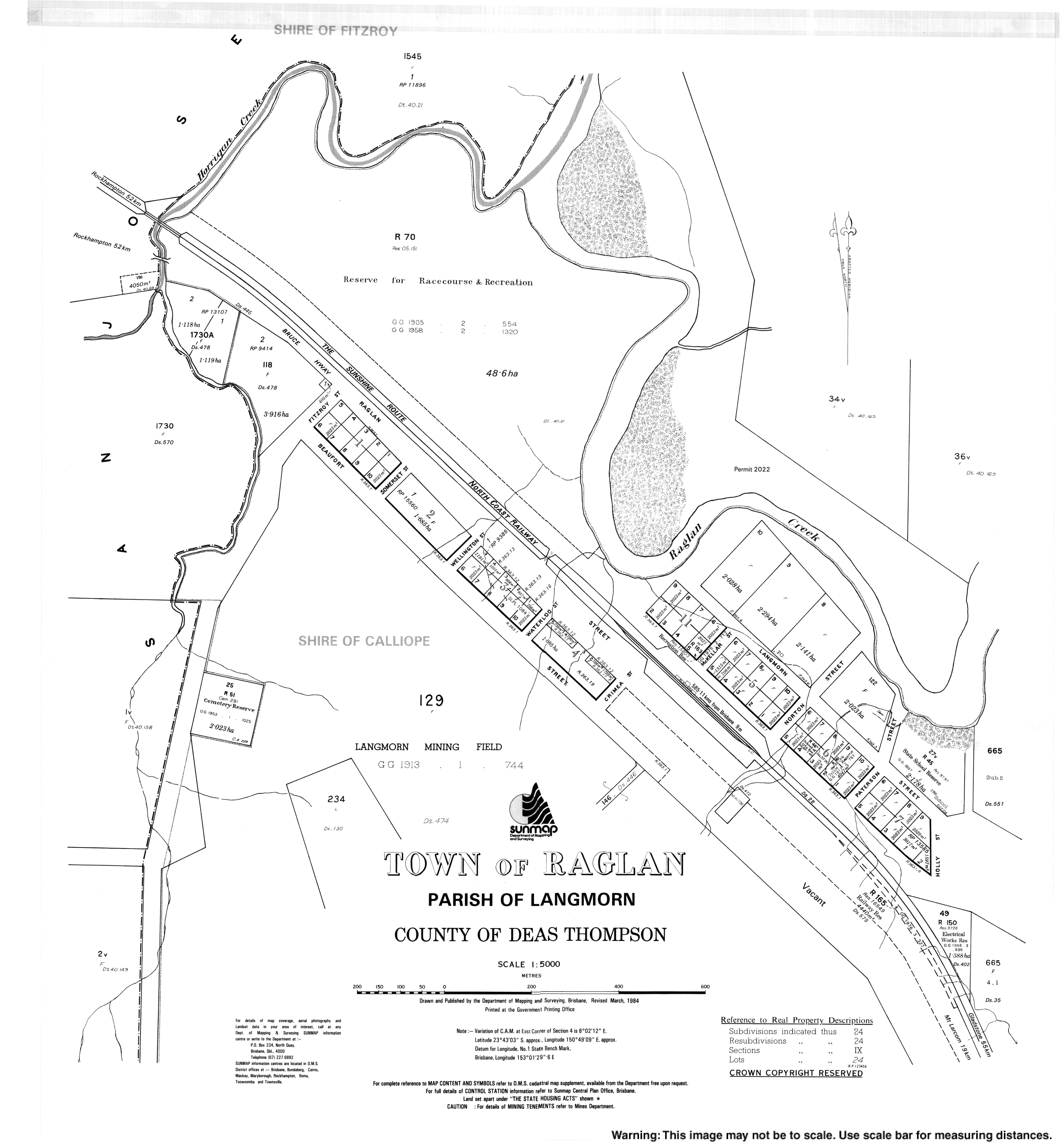
| Hourigan Creek State School | Raglan | Gladstone | 1916 | circa 1932 | approx 23°44′16″S 150°46′58″E / 23.7378°S 150.7829°E | Located on or near Hourigan Creek Road.[84][11] |
| Hut Creek State School | Ambrose | Gladstone | 1921 | 1945 | approx 23°50′52″S 150°53′55″E / 23.8477°S 150.8985°E | Located on Hut Creek Road.[85][86] |
| Ilbilbie State School | Ilbilbie | Isaac | 1930 | 1960 | 21°42′54″S 149°21′46″E / 21.7151°S 149.3628°E | Located at approx 87133 Bruce Highway.[87][88] |
| Jooro State School | Jooro (now in Goovigen) | Banana | 1935 | 1963 | 24°06′38″S 150°11′20″E / 24.1105°S 150.1888°E | Located on a five-acre (2.0 ha) site on the east of Claire Lane.[89][90] |
| Joskeleigh State School | Joskeleigh | Livingstone | 1913 | 1985 | 23°22′03″S 150°46′58″E / 23.3676°S 150.7829°E | Located at 356 Joskeleigh Road.[91][92] |
| Kalapa State School | Kalapa | Rockhampton | 1915 | 1996 | 23°30′38″S 150°16′06″E / 23.5105°S 150.2682°E | Located at 22 Kalapa Black Mountain Road.[93] |
| Kariboe Creek State School | Thangool | Banana | 1930 | 1963 | 24°27′47″S 150°31′22″E / 24.4631°S 150.5229°E | There was an earlier Kariboe Creek Provision School from 1925 to 1926. Kariboe Creek State School was located at 1 Mullers Lane.[44][94] |
| Katherine Creek State School | Katherine Creek (now in Maneroo) | Longreach | 1968 | 1979 | [95] | |
| Kokotungo State School | Kokotungo | Banana | 1939 | 1969 | ||
| Konara State School | Konara (now Oakey Creek) | Rockhampton | 1919 | 1927 | approx 23°45′48″S 150°21′36″E / 23.7633°S 150.36009°E | Located north of the Konara railway station, between the railway line and the Dee River, just south of the confluence with Fletcher Creek (approx 23°45′48″S 150°21′36″E / 23.7633°S 150.36009°E), now in Oakey Creek.[96][97] |
| Kooingal State School | Kooingal (now in Prospect) | Banana | 1931 | 1956 | 24°31′43″S 150°25′38″E / 24.5287°S 150.4271°E | Located at 1382 Crowsdale Camboon Road.[44] |
| Kroombit Provisional School | Thangool | Banana | 1933 | 1936 | [98] | |
| Laidlaw State School | via Longreach | Longreach | 1967 | 1971 | [43] | |
| Langmorn State School | Ambrose | Gladstone | 1928 | 1962 | 23°49′07″S 150°52′56″E / 23.8185°S 150.8823°E | Located at 187 Langmorn School Road.[99][100] |
| Laurinel State School | Mount Gardiner | Central Highlands | 1983 | 1987 | [101] | |
| Leichhardt Ward Boys State School | Rockhampton City | Rockhampton | 1905 | 1986 | Merged with The Hall Girls' & Infants' School | |
| Machine Creek State School | Machine Creek | Gladstone | 1911 | 1970 | 23°50′16″S 150°56′16″E / 23.8378°S 150.9377°E | Located at 540 Mount Larcom Bracewell Road (north-west corner of Ambrose Bracewell Road).[102][103] The school building was later relocated to the Calliope River Historical Village at River Ranch.[104] |
| Mahrigong State School | Corfield | Winton | 1966 | 1981 | Mahrigong is a sheep station 56 miles East from Winton.[105] | |
| Maida Hill State School | Maida Hill (now in Opalton) | Winton | 1878 | 1913 | [106] | |
| Malakoff Road State School | Theodore | Banana | 1913 | 1965 | ||
| Many Peaks State School | Many Peaks | Gladstone | 1909 | 1973 | 24°32′41″S 151°22′22″E / 24.5446°S 151.3727°E | Opened 1909 as Nanandu Provisional School, renamed 1909 Many Peaks State School.[107] Located at 5 Wentworth Street.[108][109] |
| Mardale State School | Lawgi Dawes | Banana | 1935 | 1964 | Lawgi SS until 1952 | |
| Miclere Provisional School | Kilcummin | Isaac | 1941 | 1954 | Was closed between 6 June 1943 and 24 August 1947. Miclere is now in Kilcummin.[110][111] | |
| Middlemount State High School | Middlemount | Isaac | 1988 | 2000 | Amalgamated into Middlemount Community School | |
| Middlemount State School | Middlemount | Isaac | 1980 | 2000 | Amalgamated into Middlemount Community School | |
| Morinish Provisional School | Morinish | Rockhampton | circa 1882 | circa 1890 | It is not clear if this was the same school closing and reopening or two different schools with the same name. | |
| circa 1894 | circa 1897 | |||||
| Morinish State School | Morinish | Rockhampton | 1902 | 1928 | approx 23°15′04″S 150°09′24″E / 23.2512°S 150.1566°E | Opened as Morinish No 1 Provisional School, becoming Morinish State School in 1915. It closed in 1928. It was on Morinish Road.[112] In 1930, the school building was relocated to establish Garnant State School. |
| Morinish No 2 Provisional School | Morinish | Rockhampton | 1902 | 1915 | ||
| Mount Chalmers State School | Mount Chalmers | Livingstone | 1901 | 2005 | 23°17′56″S 150°38′27″E / 23.2989°S 150.6409°E | Located at 16 School Street.[113][114] |
| Mount Scoria State School | Mount Scoria (Thangool) | Banana | 1930 | 1958 | approx 24°31′59″S 150°36′59″E / 24.5330°S 150.6164°E | Located to the immediate north-east of the Mount Scoria railway station.[56] |
| Nerimbera State School | Nerimbera | Livingstone | 1921 | 2009 | 23°24′02″S 150°35′20″E / 23.4006°S 150.5888°E | Located at 4 Graff Road on the corner Nerimbera School Road.[115][116] |
| Ogmore State School | Ogmore | Livingstone | 1924 | 1999 | 22°37′21″S 149°39′39″E / 22.6225°S 149.6609°E | Opened as Hartley Provisional School, 1933 renamed Ogmore.[117] Located at 2–4 Wilangi Street.[118][119][120] |
| Pasha State School | Pasha | Central Highlands | 1975 | 1977 | ||
| Peek-A-Doo State School | Eurombah | Banana | 1964 | 2010 | 25°54′29″S 149°29′58″E / 25.9081°S 149.4995°E | Located at 10118 Roma Taroom Road.[121] The school's website was archived.[122] |
| Pheasant Creek State School | Pheasant Creek | Banana | 1940 | 1967 | ||
| Pink Lily Lagoon State School | Pink Lily | Rockhampton | 1872 | 1971 | 23°21′27″S 150°28′13″E / 23.3576°S 150.4704°E | Located at 17 Six Mile Road.[123] |
| Playfair State | Bushley | Rockhampton | 1917 | 1928 | 23°32′11″S 150°15′58″E / 23.5364°S 150.2661°E | The school was located at approximately 213 Sandy Creek Road.[124] |
| Polmaily State School | Colosseum | Gladstone | 1900 | 1935 | 24°23′19″S 151°31′20″E / 24.3885°S 151.5221°E | Polmaily State School was at 664 Blackmans Gap Road, Colosseum.[125] |
| Raedon State School | Biloela | Banana | 1929 | 1959 | 24°21′58″S 150°29′55″E / 24.3662°S 150.4985°E | Originally Callide Bridge SS and briefly renamed Melton and Raeworth before becoming Raedon.[126] Located at 11 Teys Road,[127] now within Biloela but on the locality boundary with Dakenba.[128] |
| Raglan State School | Raglan | Gladstone | 1879 | 1996 | 23°43′11″S 150°49′25″E / 23.7196°S 150.8237°E | Located at 18 Langmorn Street.[129][11] |
| Rannes State School | Rannes | Banana | 1916 | 1966 | ||
| Red Hill State School | Mount Morgan | Rockhampton | 1900 | circa 1931 | approx 23°39′10″S 150°22′33″E / 23.6529°S 150.3758°E | Located in the Red Hill neighbourhood of Mount Morgan and is presumably the origin of the name of School Street.[130][131] |
| Riverston State School | Taragoola | Gladstone | circa 1936 | 1960 | Coordinates for Riverston are within Lake Awoonga so may have been inundated by the construction of the dam[132] | |
| Rockhampton Central Boys' State School | Rockhampton City | Rockhampton | 1862 | 1963 | ||
| Rockhampton Central Girls' State School | Rockhampton City | Rockhampton | 1875 | 1973 | ||
| Rockhampton Central Infants School | Rockhampton City | Rockhampton | 1876 | 1962 | Merged into Girls' School | |
| Rockhampton North State School | Frenchville | Rockhampton | 1871 | 1966 | Split sex 1888–1920 | |
| Rocky Crossing State School | Jundah | Barcoo | 1988 | 2003 | [133] | |
| Rossmoya State School | Rossmoya | Livingstone | 1923 | 1968 | 23°01′32″S 150°29′03″E / 23.02557°S 150.48425°E | Located at 1770 Rossmoya Road.[134] |
| Rubyvale State School | Rubyvale | Central Highlands | 1908 | 1963 | ||
| Sapphire State School | Sapphire | Central Highlands | 1904 | 1939 | ||
| Sleipner Junction Provisional School | Nankin | Livingstone | 1913 | 1923 | ||
| Spring Creek State School | Spring Creek | Banana | 1871 | 1954 | ||
| Spring Creek Upper State School | Spring Creek Upper | Banana | 1915 | 1970 | ||
| Struck Oil State School | Struck Oil | Rockhampton | 1905 | 1944 | approx 23°36′44″S 150°27′04″E / 23.61226°S 150.45112°E | Located on the south side of Struck Oil Road.[135] |
| Styx River State School | Styx (now in Ogmore) | Livingstone | 1919 | 1942 | 22°35′30″S 149°38′01″E / 22.5916°S 149.6337°E | Located on Styx Road near the railway station.[136][137] |
| Surprise Creek State School | now in Opalton | Winton | circa 1902 | circa 1908 | [138] | |
| Tableland Provisional School | Tablelands | Gladstone | 1905 | c. 1916 | approx 24°17′29″S 150°57′03″E / 24.29139°S 150.95093°E | Located on Tableland Road.[139] |
| Targinnie State School | Targinnie | Gladstone | 1923 | 1968 | ||
| Ten Mile Creek Provisional School | Morinish | Rockhampton | 1916 | circa 1917 | ||
| Thompson's Point State School | Thompsons Point | Livingstone | 1906 | 1929 | ||
| Tiamby Provisional School | Thangool | Banana | 1933 | 1942 | 24°40′53″S 150°28′26″E / 24.6813°S 150.4738°E | Located on the north-eastern corner of 3224 Crowsdale Camboon Road.[44][140] |
| Turkey Road State School | Bororen | Gladstone | 1921 | 1931 | approx 24°13′05″S 151°31′50″E / 24.2181°S 151.5305°E | Located on Bates Road.[141] |
| Ulam South State School | via Bajool | Rockhampton | 1894 | 1925 | ||
| Ulam Upper State School | via Bajool | Rockhampton | circa 1892 | circa 1961 | ||
| Valentine Plains State School | Valentine Plains | Banana | 1928 | 1967 | 24°25′10″S 150°34′46″E / 24.4195°S 150.5795°E | Located on Valentine Plains Road.[44] |
| Walterhall State School | Walterhall | Rockhampton | 1917 | 1969 | ||
| Wartburg State School | Wartburg | Gladstone | 1913 | 1966 | ||
| Wattlebank State School | Barmoya? | Livingstone | 1918 | 1933 | Barmoya Central State School opened on 28 August 1918.[142] In February 1930, the school was closed because it had only seven students; it was suggested that the school should be moved to a more central location.[143] In October 1931, it was proposed to relocate the school building to Rossmoya Road where 16 students could attend the school,[144][145] but some parents thought it was too distant for their children to travel to and from the school each day.[146][147] In June 1932, it was decided to move the school to Rossmoya Road,[148] but, in March 1933, the government said there were insufficient funds available to move the school at that time.[149] | |
| Wattlebank | 1934 | 1959 | 23°07′49″S 150°27′34″E / 23.13030°S 150.45931°E | In September 1933, tenders were called to relocate the school.[150] The school was relocated in January 1934.[151] In 1936, it was renamed Wattlebank State School.[152] It closed in December 1959.[153] It was on the western side of Rossmoya Road in Wattlebank.[154][155] | ||
| West Hill State School | Carmila | Isaac | 1925 | 2004 | 21°48′36″S 149°22′16″E / 21.8099°S 149.3710°E | West Hill is an unbounded locality in the north of the locality of Carmila.[156] Located at 14 Red Hill Road.[157][158][159] The school website was archived.[160] |
| Withersfield State School | Withersfield (now within Willows) | Central Highlands | 1920 | circa 1942 | approx 23°34′33″S 147°33′51″E / 23.5757°S 147.5643°E | Located north of the former town of Withersfield on a five-acre-two-rood-eleven-perch (2.25 ha) site.[161][162] |
| Wooderson State School | Wooderson | Gladstone | 1945 | 1960 | ||
| Woolein State School | Woolein | Banana | 1918 | 1924 | ||
| Wura State School | Wura | Rockhampton | 1924 | circa 1944 | approx 23°48′58″S 150°19′38″E / 23.8160°S 150.3273°E | Located between the Wuru railway station and the Dee River.[163] |
| Yaamba State School | Yaamba | Livingstone | 1867 | 1940 | approx 23°07′58″S 150°22′01″E / 23.1328°S 150.3670°E | Located on the north-west corner of Iris Street and Yaamba Siding Road.[164] |
| Yalleroi State School | Yalleroi | Blackall-Tambo | 1933 | 1983 | ||
| Yaparaba State School | Lawgi Dawes | Banana | 1934 | 1970 | approx 24°38′07″S 150°42′28″E / 24.63521°S 150.70782°E | Located on a bend in Yaparaba School Road to the immediate south of the never-constructed Yaparaba railway station on the never-constructed section of the Callide Valley railway line.[56] |
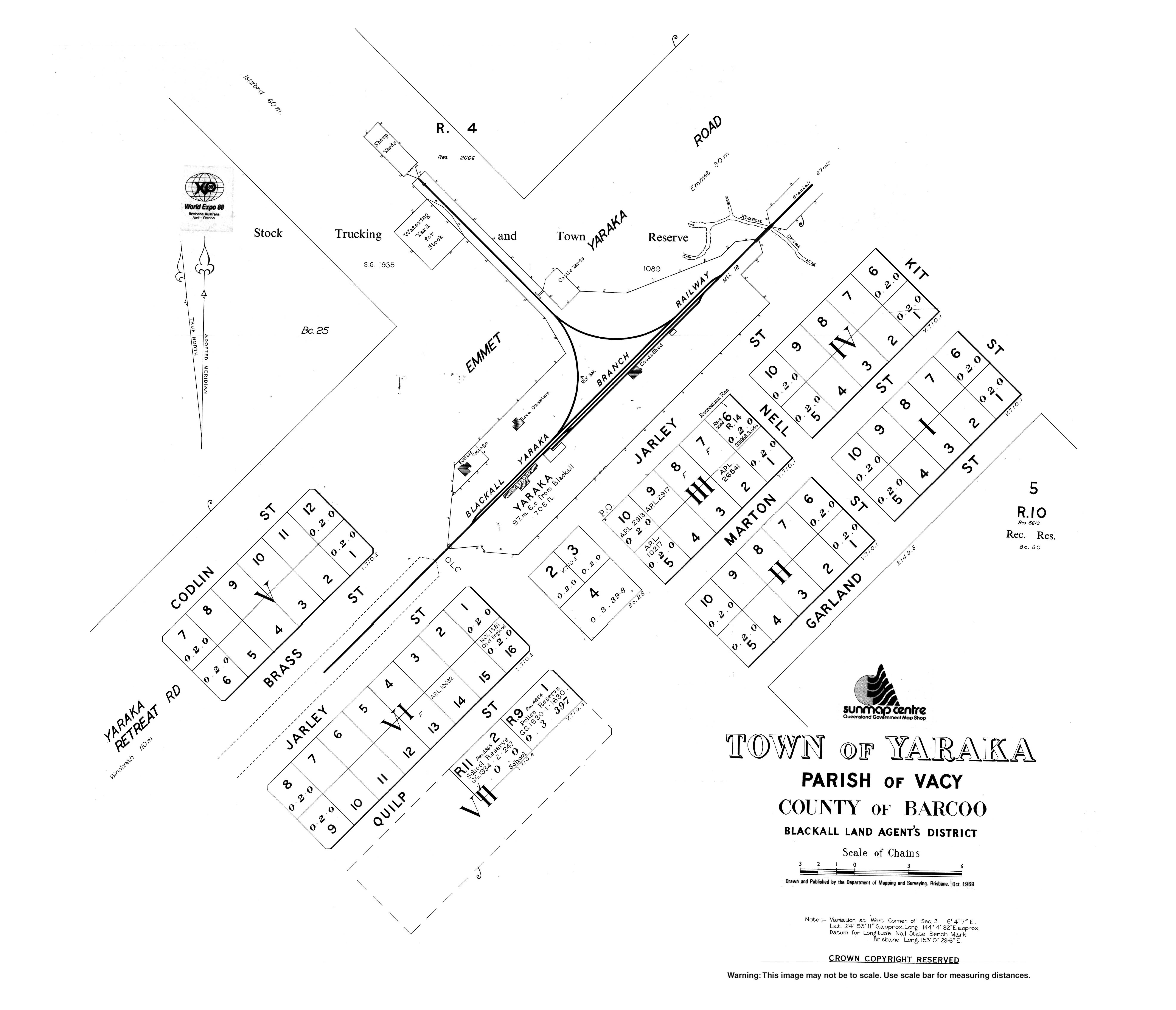
| Yaraka State School | Yaraka | Longreach | 1920 | 2009 | 24°53′10″S 144°04′31″E / 24.8861°S 144.0754°E | Located at 11 Quilp Street.[165] The school's website was archived.[166] |
| Yeppoon State Infants School | Yeppoon | Livingstone | 1957 | 1968 | Merged into SS |
Private schools[edit]
Catholic schools[edit]
In Queensland, Catholic primary schools are usually (but not always) linked to a parish. Prior to the 1970s, most schools were founded by religious institutes, but with the decrease in membership of these institutes, together with major reforms inside the church, lay teachers and administrators began to take over the schools, a process which completed by approximately 1990.
Within the region, schools are administered by Catholic Education Office, Diocese of Rockhampton, which was established in 1966 and was the first Catholic Education Office (CEO) in Queensland. They are supported by the Queensland Catholic Education Commission, which is responsible for coordinating administration, curriculum and policy across the Catholic school system. Preference for enrolment is given to Catholic students from the parish or local area, although non-Catholic students are admitted if room is available.
| Name | Suburb | LGA | M/F/Co-ed | Years | Opened | Coordinates | Notes |
|---|---|---|---|---|---|---|---|
| Chanel College | West Gladstone | Gladstone | Co-ed | 7–12 | 1966 | ||
| Emmaus College | Park Avenue | Rockhampton | Co-ed | 7–12 | 1983 | ||
| Marist College Emerald | Emerald | Central Highlands | Co-ed | 7–12 | 1996 | ||
| Our Lady's Primary School | Longreach | Longreach | Co-ed | P–6 | 1902 | ||
| Our Lady of the Sacred Heart Primary School | Springsure | Central Highlands | Co-ed | P–6 | 1926 | ||
| Rockhampton Flexible Learning Centre | Rockhampton | Rockhampton | Co-ed | 7–12 | Operated by Edmund Rice Foundation. | ||
| Sacred Heart Primary School (Yeppoon) | Lammermoor | Livingstone | Co-ed | P–6 | 1958 | ||
| St Anthony's Catholic Primary School | Norman Gardens | Rockhampton | Co-ed | P–6 | 1900 | ||
| St Benedict's Catholic Primary School | Pacific Heights | Livingstone | Co-ed | P–6 | 2009 | ||
| St. Brendan's College | Adelaide Park | Livingstone | M | 7–12 | 1939 | 23°06′58″S 150°43′48″E / 23.1162°S 150.7300°E | 139 Adelaide Park Road.[167] |
| St Brigid's Catholic Primary School | Emerald | Central Highlands | Co-ed | P–6 | |||
| St Francis' Catholic Primary School | Tannum Sands | Gladstone | Co-ed | P–6 | 2005 | ||
| St John the Baptist Catholic Primary School | Clinton | Gladstone | Co-ed | P–6 | 1977 | ||
| St Joseph's Catholic Primary School | Barcaldine | Barcaldine | Co-ed | P–6 | 1896 | ||
| St Joseph's Catholic School | Biloela | Banana | Co-ed | P–6 | 1939 | ||
| St Joseph's Catholic Primary School | Blackall | Blackall-Tambo | Co-ed | P–6 | 1917 | ||
| St Joseph's School | Clermont | Central Highlands | Co-ed | P–6 | 1900 | ||
| St Joseph's Primary School | Park Avenue | Rockhampton | Co-ed | P–6 | 1929 | ||
| St Joseph's Primary School | Wandal | Rockhampton | Co-ed | P–6 | 1916 | ||
| St Mary's Catholic Primary School | Berserker | Rockhampton | Co-ed | P–6 | 1900 | ||
| St Patrick's School | Emerald | Central Highlands | Co-ed | P–6 | 1902 | ||
| St Patrick's School | Winton | Winton | Co-ed | P–6 | 1906 | ||
| St Paul's Primary School | Gracemere | Rockhampton | Co-ed | P–6 | 1988 | ||
| St Peter's School | Allenstown | Rockhampton | Co-ed | P–6 | 1934 | ||
| St Ursula's College | Yeppoon | Livingstone | F | 7–12 | 1918 | 23°07′48″S 150°44′36″E / 23.1300°S 150.7434°E | 42–62 Queen Street.[168] |
| Star of the Sea School | Gladstone Central | Gladstone | Co-ed | P–6 | 1902 | ||
| The Cathedral College | Rockhampton City | Rockhampton | Co-ed | 7–12 | 1991 |
Independent schools[edit]
| Name | Suburb | LGA | M/F/Co-ed | Years | Category | Opened | Notes |
|---|---|---|---|---|---|---|---|
| Carinity Education | Glenlee | Livingstone | Co-ed | ? | Baptist | 1996 | Alternative[169] |
| Clearview Christian College | Tannum Sands | Gladstone | Co-ed | 7–10 | Christian | ||
| Discovery Christian College | Agnes Water | Gladstone | Co-ed | P–12 | Christian | 2015 | |
| Emerald Christian College | Emerald | Central Highlands | Co-ed | P–12 | Christian | 2001 | |
| Faith Baptist Christian School | Burua | Gladstone | Co-ed | P–12 | Baptist | 1998 | |
| Goora Gan Steiner School | Agnes Water | Gladstone | Co-ed | P–6 | Steiner | ||
| Heights College | Kawana | Rockhampton | Co-ed | P–12 | Assemblies of God | 1989 | Cathedral of Praise Christian College until 2003 |
| Kingsley College | The Common | Rockhampton | Co-ed | P–12 | Christian | 1993 | Formerly Central Queensland Christian College |
| Lighthouse Christian School | Norman Gardens | Rockhampton | Co-ed | P–12 | Baptist | 1994 | Formerly Norman Park Christian School |
| Ontrack College Emerald | Emerald | Central Highlands | Co-ed | 7–10 | Christian | Special School | |
| Redeemer Lutheran College | Biloela | Banana | Co-ed | P–12 | Lutheran | 1978 | |
| Rockhampton Girls Grammar School | The Range | Rockhampton | F | P–12 | Non-denominational | 1892 | |
| Rockhampton Grammar School | The Range | Rockhampton | Co-ed | P–12 | Non-denominational | 1881 | |
| Trinity College | Sun Valley | Gladstone | Co-ed | P–12 | Baptist | 1985 | |
| Wadja Wadja High School | Woorabinda | Woorabinda | Co-ed | 7–12 | Aboriginal | 1991 |
Defunct private schools[edit]
| Name | Suburb | LGA | Category | Years | Opened | Closed | Notes |
|---|---|---|---|---|---|---|---|
| Capricorn Christian Primary School | Kawana | Rockhampton | 7DA | Primary | 1972 | 2001 | |
| Glenden Christian School | Glenden | Isaac | Christian | Primary | 1995 | 1997 | |
| Marian College | Park Avenue | Rockhampton | Catholic girls | High | 1964 | 1983 | Merged into Emmaus College |
| Range Convent High School | Rockhampton City | Rockhampton | Catholic girls | High | 1896 | 1990 | Merged into The Cathedral College |
| Range Convent High School | Woorabinda | Woorabinda | Catholic | High | 1987 | 1990 | |
| Sacred Heart Primary School | Mount Morgan | Rockhampton | Catholic | Primary | 1891 | 1997 | |
| St Faith’s School | Yeppoon | Livingstone | Anglican Girls | P–12 | 1923 | 1968 | |
| St Joseph's Christian Brothers College | Rockhampton City | Rockhampton | Catholic boys | High | 1894 | 1990 | Merged into The Cathedral College |
| St Mary's School | Taroom | Banana | Catholic | Primary | 1920 | 2015 | |
| St Stanislaus College | Park Avenue | Rockhampton | Catholic boys | High | 1958 | 1983 | Merged into Emmaus College |
| St Stephen's Lutheran College | Glen Eden | Gladstone | Lutheran | P–12 | 2002 | 2016 | |
| Stella Maris College | Gladstone | Gladstone | Catholic | High | 1966 | 1976 | Became Part of Chanel College |
See also[edit]
References[edit]
- ^ "Year 7 is moving to high school | Education and training | Queensland Government". www.qld.gov.au. Archived from the original on 13 July 2015. Retrieved 1 July 2015.
- ^ Google (18 December 2022). "Anakie State School" (Map). Google Maps. Google. Retrieved 18 December 2022.
- ^ "Prospect Creek State School". Prospect Creek State School. 29 November 2020. Archived from the original on 27 December 2022. Retrieved 27 December 2022.
- ^ "Springsure State School". Springsure State School. 29 November 2020. Archived from the original on 2 March 2023. Retrieved 13 August 2023.
- ^ "Taranganba State School". Taranganba State School. 29 November 2020. Archived from the original on 19 March 2020. Retrieved 24 September 2023.
- ^ "State and non-state school details". Queensland Government. 9 July 2018. Archived from the original on 21 November 2018. Retrieved 21 November 2018.
- ^ "Yeppoon State School (former) (entry 602404)". Queensland Heritage Register. Queensland Heritage Council. Retrieved 16 December 2022.
- ^ "Yeppoon State School (entry 650231)". Queensland Heritage Register. Queensland Heritage Council. Retrieved 16 December 2022.
- ^ "Yeppoon State High School". Yeppoon State High School. 18 February 2022. Archived from the original on 3 October 2023. Retrieved 24 September 2023.
- ^ "County of Livingstone sheet 1" (Map). Queensland Government. 1912. Archived from the original on 22 February 2020. Retrieved 16 January 2021.
- ^ a b c d e f g "Queensland Globe". State of Queensland. Retrieved 11 December 2021.
- ^ Queensland State Archives
- ^ "Miriam Vale" (Map). Queensland Government. 1944. Archived from the original on 13 July 2021. Retrieved 13 July 2021.
- ^ a b c d Queensland Family History Society (2010), Queensland schools past and present (Version 1.01 ed.), Queensland Family History Society, ISBN 978-1-921171-26-0
- ^ "Queensland Two Mile series sheet 2m237" (Map). Queensland Government. 1962. Archived from the original on 22 September 2023. Retrieved 22 September 2023.
- ^ "Bathampton – parish in Isaac Region (entry 1841)". Queensland Place Names. Queensland Government. Retrieved 14 January 2018.
- ^ "Town of Bogantungan" (Map). Queensland Government. 1971. Archived from the original on 14 January 2020. Retrieved 22 July 2022.
- ^ "OFFICIAL NOTIFICATIONS". The Brisbane Courier. Vol. XXXVIII, no. 8, 067. Queensland, Australia. 17 November 1883. p. 6. Retrieved 25 April 2024 – via National Library of Australia.
- ^ "County of Pakingham" (Map). Queensland Government. 1921. Retrieved 25 April 2024.
- ^ "Town map of Boolburra" (Map). Queensland Government. 1968. Retrieved 25 April 2024.
- ^ "Langmorn" (Map). Queensland Government. 1943. Archived from the original on 13 March 2020. Retrieved 28 April 2022.
- ^ "Parish of Nolan" (Map). Queensland Government. 1980. Archived from the original on 28 April 2022. Retrieved 28 April 2022.
- ^ "Braeside – railway station in Isaac Region (entry 4273)". Queensland Place Names. Queensland Government. Retrieved 15 January 2018.
- ^ "Deeford" (Map). Queensland Government. 1944. Archived from the original on 18 January 2022. Retrieved 2 May 2022.
- ^ "Parish of Bunerba" (Map). Queensland Government. 1969. Archived from the original on 11 April 2022. Retrieved 2 May 2022.
- ^ "Queensland Two Mile series sheet 2m202 Rannes" (Map). Queensland Government. 1933. Archived from the original on 24 November 2022. Retrieved 24 November 2022.
- ^ "STATE SCHOOL AT BUNERU". Morning Bulletin. No. 16621. Queensland, Australia. 8 December 1917. p. 4. Archived from the original on 13 August 2023. Retrieved 24 November 2022 – via National Library of Australia.
- ^ "WALLS OF WATER". The Brisbane Courier. No. 21, 922. Queensland, Australia. 1 May 1928. p. 17. Archived from the original on 13 August 2023. Retrieved 24 November 2022 – via National Library of Australia.
- ^ "Appalling losses". Queensland Times. Vol. LXVIII, no. 13, 034. Queensland, Australia. 1 May 1928. p. 7. Archived from the original on 13 August 2023. Retrieved 24 November 2022 – via National Library of Australia.
- ^ "BUNERU". Morning Bulletin. No. 21, 165. Queensland, Australia. 25 May 1934. p. 7. Archived from the original on 13 August 2023. Retrieved 24 November 2022 – via National Library of Australia.
- ^ "BUNERU". The Central Queensland Herald. Vol. 6, no. 232. Queensland, Australia. 7 June 1934. p. 39. Archived from the original on 13 August 2023. Retrieved 24 November 2022 – via National Library of Australia.
- ^ "Queensland Two Mile series sheet 2m202" (Map). Queensland Government. 1939. Archived from the original on 24 November 2022. Retrieved 24 November 2022.
- ^ "Deeford" (Map). Queensland Government. 1944. Archived from the original on 18 January 2022. Retrieved 11 April 2022.
- ^ "Queensland Two Mile series sheet 2m237" (Map). Queensland Government. 1941. Archived from the original on 1 February 2024. Retrieved 23 September 2023.
- ^ "Reserves". The Brisbane Courier. No. 18, 640. Queensland, Australia. 13 October 1917. p. 3. Retrieved 5 November 2020 – via National Library of Australia.
- ^ "Parish of Targinie" (Map). Queensland Government. 1975. Archived from the original on 5 November 2020. Retrieved 5 November 2020.
- ^ "8949-II-N Callide" (Map). Queensland Government. 1972. Archived from the original on 12 June 2022. Retrieved 13 June 2022.
- ^ "Queensland Globe". State of Queensland. Retrieved 12 June 2022.
- ^ "Queensland Two Mile series sheet 2m201" (Map). Queensland Government. 1954. Archived from the original on 3 May 2021. Retrieved 22 January 2022.
- ^ "Calliungal – unbounded locality in the Rockhampton Region (entry 5777)". Queensland Place Names. Queensland Government. Retrieved 15 January 2018.
- ^ "Town of Mount Morgan sheet 2" (Map). Queensland Government. 1973. Archived from the original on 28 July 2023. Retrieved 28 July 2023.
- ^ "Westwood" (Map). Queensland Government. 1942. Archived from the original on 28 July 2023. Retrieved 28 July 2023.
- ^ a b Queensland Family History Society (2010), Queensland schools past and present (Version 1.01 ed.), Queensland Family History Society, ISBN 978-1-921171-26-0
- ^ a b c d e f g "Queensland Two Mile series sheet 2m163" (Map). Queensland Government. 1950. Archived from the original on 26 December 2022. Retrieved 27 December 2022.
- ^ "Queensland Globe". State of Queensland. Retrieved 17 February 2023.
Land parcel 51N25413 has name attribute Old Cairdbeign School
- ^ "Langmorn" (Map). Queensland Government. 1943. Archived from the original on 13 March 2020. Retrieved 2 June 2022.
- ^ "Queensland Two Mile series sheet 2m201" (Map). Queensland Government. 1954. Archived from the original on 3 May 2021. Retrieved 2 June 2022.
- ^ "Clio – parish in Shire of Winton (entry 7459)". Queensland Place Names. Queensland Government. Retrieved 15 January 2018.
- ^ "Agency ID 13187, Coominglah State School". Queensland State Archives. Retrieved 28 December 2022.
- ^ "Queensland Two Mile series sheet 2m163" (Map). Queensland Government. 1950. Archived from the original on 13 June 2022. Retrieved 13 June 2022.
- ^ "Coreen – parish in the Banana Shire (entry 8438)". Queensland Place Names. Queensland Government. Retrieved 13 June 2022.
- ^ "Environs of Cracow" (Map). Queensland Government. 1963. Archived from the original on 11 December 2021. Retrieved 11 December 2021.
- ^ "Parish of Limestone" (Map). Queensland Government. 1972. Archived from the original on 29 December 2020. Retrieved 30 December 2020.
- ^ "5 Shannen Road, Dalma, Qld 4702". Realestate.com.au. Retrieved 22 April 2022.[permanent dead link]
- ^ "County of Livingstone sheet 1" (Map). Queensland Government. 1923. Archived from the original on 13 August 2023. Retrieved 14 August 2023.
- ^ a b c "Queensland Two Mile series sheet 2m163" (Map). Queensland Government. 1939. Archived from the original on 26 December 2022. Retrieved 27 December 2022.
- ^ "CALLIDE". The Telegraph. Queensland, Australia. 21 October 1931. p. 4 (FIRST EDITION). Archived from the original on 13 August 2023. Retrieved 27 December 2022 – via National Library of Australia.
- ^ "Advertising". Morning Bulletin. No. 20, 437. Queensland, Australia. 16 January 1932. p. 1. Archived from the original on 13 August 2023. Retrieved 27 December 2022 – via National Library of Australia.
- ^ "DAWES". The Central Queensland Herald. Vol. 3, no. 131. Queensland, Australia. 30 June 1932. p. 38. Archived from the original on 13 August 2023. Retrieved 27 December 2022 – via National Library of Australia.
- ^ "Queensland Two Mile series sheet 2m201" (Map). Queensland Government. 1937. Archived from the original on 9 April 2022. Retrieved 11 April 2022.
- ^ "DON RIVER SCHOOL". Morning Bulletin. No. 16, 004. Queensland, Australia. 11 November 1915. p. 6. Archived from the original on 1 February 2024. Retrieved 1 February 2024 – via National Library of Australia.
- ^ "TENDERS ACCEPTED". The Telegraph. No. 13, 527. Queensland, Australia. 30 March 1916. p. 3. Archived from the original on 1 February 2024. Retrieved 1 February 2024 – via National Library of Australia.
- ^ "OFFICIAL NOTIFICATIONS". The Capricornian. Vol. 41, no. 31. Queensland, Australia. 29 July 1916. p. 30. Archived from the original on 1 February 2024. Retrieved 1 February 2024 – via National Library of Australia.
- ^ "DAWSON VALLEY SCHOOLS". Morning Bulletin. No. 16, 244. Queensland, Australia. 5 September 1916. p. 4. Archived from the original on 1 February 2024. Retrieved 1 February 2024 – via National Library of Australia.
- ^ "WOWAN". The Central Queensland Herald. Vol. 4, no. 171. Queensland, Australia. 6 April 1933. p. 39. Archived from the original on 1 February 2024. Retrieved 2 February 2024 – via National Library of Australia.
- ^ "Queensland Two Mile series sheet 2m201" (Map). Queensland Government. 1954. Archived from the original on 3 May 2021. Retrieved 11 April 2022.
- ^ "Deeford" (Map). Queensland Government. 1944. Archived from the original on 18 January 2022. Retrieved 11 April 2022.
- ^ "Parish of Bunerba" (Map). Queensland Government. 1969. Archived from the original on 11 April 2022. Retrieved 11 April 2022.
- ^ "Agency ID 5902, Earlsfield State School". Queensland State Archives. Retrieved 1 February 2024.
- ^ "Queensland Two Mile series sheet 2m201" (Map). Queensland Government. 1964. Archived from the original on 31 January 2024. Retrieved 1 February 2024.
- ^ "Rannes" (Map). Queensland Government. 1944. Archived from the original on 31 January 2024. Retrieved 1 February 2024.
- ^ Queensland Family History Society (2010), Queensland schools past and present (Version 1.01 ed.), Queensland Family History Society, ISBN 978-1-921171-26-0
- ^ "Parish of Boolburra" (Map). Queensland Government. 1962. Retrieved 25 April 2024.
- ^ "Edungalba (Herberts Creek) – railway station in Central Highlands Region (entry 11220)". Queensland Place Names. Queensland Government. Retrieved 15 January 2018.
- ^ "Evesham State School". Evesham State School. 10 January 2007. Archived from the original on 10 January 2007. Retrieved 8 April 2022.
- ^ "Town of Fernlees" (Map). Queensland Government. 1972. Archived from the original on 17 July 2020. Retrieved 22 July 2022.
- ^ "Agency ID 6637, Flaggy Rock Creek State School". Queensland State Archives. Retrieved 29 July 2016.
- ^ "Parish of Porphyry Hill" (Map). Queensland Government. 1977. Archived from the original on 3 May 2022. Retrieved 3 May 2022.
- ^ "Yaamba" (Map). Queensland Government. 1942. Archived from the original on 13 January 2021. Retrieved 13 January 2021.
- ^ "Parish of Greycliffe" (Map). Queensland Government. 1967. Archived from the original on 5 November 2020. Retrieved 5 November 2020.
- ^ "Westwood" (Map). Queensland Government. 1942. Archived from the original on 18 January 2022. Retrieved 9 April 2022.
- ^ "8950 Mount Morgan" (Map). Queensland Government. 1972. Archived from the original on 24 January 2022. Retrieved 9 April 2022.
- ^ "Parish of Calliungal" (Map). Queensland Government. 1983. Archived from the original on 9 April 2022. Retrieved 9 April 2022.
- ^ "Queensland Two Mile series sheet 2m203" (Map). Queensland Government. 1935. Archived from the original on 3 May 2021. Retrieved 3 May 2021.
- ^ "Langmore" (Map). Queensland Government. 1943. Archived from the original on 13 March 2020. Retrieved 9 April 2022.
- ^ "Queensland Two Mile series sheet 2m201" (Map). Queensland Government. 1937. Archived from the original on 9 April 2022. Retrieved 9 April 2022.
- ^ "Kelvin" (Map). Queensland Government. 1943. Archived from the original on 9 April 2022. Retrieved 10 April 2022.
- ^ "Queensland Two Mile series sheet 2m279" (Map). Queensland Government. 1952. Archived from the original on 9 April 2022. Retrieved 10 April 2022.
- ^ "Queensland Two Mile series sheet 2m202" (Map). Queensland Government. 1939. Archived from the original on 24 November 2022. Retrieved 24 November 2022.
- ^ "Jooro – railway station in Shire of Banana (entry 17347)". Queensland Place Names. Queensland Government. Retrieved 15 January 2018.
- ^ "Rockhampton" (Map). Queensland Government. 1944. Archived from the original on 9 April 2022. Retrieved 9 April 2022.
- ^ "Parish of Meadow Flats" (Map). Queensland Government. 1974. Archived from the original on 9 April 2022. Retrieved 9 April 2022.
- ^ "Parish of Stanwell" (Map). Queensland Government. 1979. Archived from the original on 3 May 2022. Retrieved 3 May 2022.
- ^ "Kariboe Creek – creek in the Shire of Banana (entry 17743)". Queensland Place Names. Queensland Government. Retrieved 15 January 2018.
- ^ "Katherine Creek – creek in Longreach Region (entry 17799)". Queensland Place Names. Queensland Government. Retrieved 15 January 2018.
- ^ "Queensland Two Mile series sheet 2m201" (Map). Queensland Government. 1937. Archived from the original on 25 August 2023. Retrieved 25 August 2023.
- ^ "Queensland Globe". State of Queensland. Retrieved 25 August 2023.
- ^ "Kroombit – parish in Shire of Banana (entry 18545)". Queensland Place Names. Queensland Government. Retrieved 15 January 2018.
- ^ "Langmorn" (Map). Queensland Government. 1943. Archived from the original on 13 March 2020. Retrieved 3 May 2021.
- ^ "Queensland Two Mile series sheet 2m201" (Map). Queensland Government. 1954. Archived from the original on 3 May 2021. Retrieved 3 May 2021.
- ^ "Agency ID 11754, Laurinel State School". Queensland State Archives. Retrieved 15 January 2018.
- ^ "Langmorn" (Map). Queensland Government. 1943. Archived from the original on 13 March 2020. Retrieved 4 June 2022.
- ^ "9050 Bajool" (Map). Queensland Government. 1973. Archived from the original on 4 June 2022. Retrieved 4 June 2022.
- ^ "Machine Creek School". Calliope River Historical Village. Archived from the original on 22 June 2014. Retrieved 23 April 2014.
- ^ "Seadogs Grownups". Archived from the original on 12 March 2018. Retrieved 15 January 2018.
- ^ "Maida Hill – hill in Shire of Winton (entry 20593)". Queensland Place Names. Queensland Government. Retrieved 15 January 2018.
- ^ "Agency ID 6522, Many Peaks State School". Queensland State Archives. Retrieved 4 June 2022.
- ^ "Towns of Many Peaks" (Map). Queensland Government. 1984. Archived from the original on 16 January 2021. Retrieved 4 June 2022.
- ^ "9148-14 Many Peaks" (Map). Queensland Government. 1975. Archived from the original on 4 June 2022. Retrieved 4 June 2022.
- ^ "Miclere – parish in the Isaac Region (entry 21786)". Queensland Place Names. Queensland Government. Retrieved 17 January 2018.
- ^ "Queensland Globe". State of Queensland. Retrieved 30 December 2021.
- ^ "County of Livingstone sheet 1" (Map). Queensland Government. 1921. Archived from the original on 13 August 2023. Retrieved 14 August 2023.
- ^ Chiclcott, Tanya; Vlasic, Kimberley (7 June 2013). "Full school asssets sale list". The Courier-Mail. Archived from the original on 30 October 2019. Retrieved 30 October 2019.
- ^ Google (22 April 2022). "Mount Chalmers State School (former)" (Map). Google Maps. Google. Retrieved 22 April 2022.
- ^ Chiclcott, Tanya; Vlasic, Kimberley (7 June 2013). "Full school asssets sale list". The Courier-Mail. Archived from the original on 30 October 2019. Retrieved 30 October 2019.
- ^ "Parish of Archer" (Map). Queensland Government. 1977. Archived from the original on 13 April 2022. Retrieved 13 April 2022.
- ^ Queensland Family History Society (2010), Queensland schools past and present (Version 1.01 ed.), Queensland Family History Society, ISBN 978-1-921171-26-0
- ^ "Styx" (Map). Queensland Government. 1943. Archived from the original on 29 April 2022. Retrieved 30 April 2022.
- ^ "Queensland Two Mile series sheet 2m240" (Map). Queensland Government. 1941. Archived from the original on 29 April 2022. Retrieved 30 April 2022.
- ^ "Styx" (Map). Queensland Government. 1975. Archived from the original on 29 April 2022. Retrieved 30 April 2022.
- ^ "Hornet Bank" (Map). Queensland Government. 1972. Archived from the original on 8 April 2022. Retrieved 8 April 2022.
- ^ "Peek-A-Doo State School". Peek-A-Doo State School. 27 October 2009. Archived from the original on 27 October 2009. Retrieved 8 April 2022.
- ^ "Ridgelands" (Map). Queensland Government. 1946. Archived from the original on 20 August 2023. Retrieved 20 August 2023.
- ^ "County of Livingstone Sheet 1" (Map). Queensland Government. 1924. Archived from the original on 22 February 2020. Retrieved 28 December 2020.
- ^ "Pomaily State School War Memorial". Queensland War Memorial Register. Queensland Government. Archived from the original on 15 January 2018. Retrieved 15 January 2018.
- ^ "Agency ID 5947, Raedon State School". Queensland State Archives. Retrieved 16 January 2018.
- ^ "Queensland Two Mile series sheet 2m163" (Map). Queensland Government. 1950. Archived from the original on 13 June 2022. Retrieved 13 June 2022.
- ^ "Queensland Globe". State of Queensland. Retrieved 13 June 2022.
- ^ "Town of Raglan" (Map). Queensland Government. 1984. Archived from the original on 3 May 2021. Retrieved 3 May 2021.
- ^ "County of Livingstone sheet 1" (Map). Queensland Government. 1912. Archived from the original on 22 February 2020. Retrieved 11 April 2022.
- ^ "Town of Mount Morgan" (Map). Queensland Government. 1972. Archived from the original on 11 April 2022. Retrieved 11 April 2022.
- ^ "Riverston – unbounded locality in Gladstone Region (entry 28542)". Queensland Place Names. Queensland Government. Retrieved 30 September 2017.
- ^ "Rocky Crossing – ford in the Shire of Barcoo (entry 28815)". Queensland Place Names. Queensland Government. Retrieved 16 January 2018.
- ^ "Queensland Two Mile series sheet 2m237" (Map). Queensland Government. 1952. Archived from the original on 22 September 2023. Retrieved 22 September 2023.
- ^ "Westwood" (Map). Queensland Government. 1942. Archived from the original on 28 July 2023. Retrieved 21 August 2023.
- ^ "Styx" (Map). Queensland Government. 1943. Archived from the original on 29 April 2022. Retrieved 30 April 2022.
- ^ "Queensland Two Mile series sheet 2m240" (Map). Queensland Government. 1941. Archived from the original on 29 April 2022. Retrieved 30 April 2022.
- ^ "Surprise Creek – creek in the Shire of Winton (entry 32901)". Queensland Place Names. Queensland Government. Retrieved 16 January 2018.
- ^ "Queensland Two Mile series sheet 2m163" (Map). Queensland Government. 1939. Archived from the original on 1 February 2024. Retrieved 18 January 2024.
- ^ "Agency ID 10589, Tiamby State School". Queensland State Archives. Retrieved 27 December 2022.
- ^ "County of Flinders" (Map). Queensland Government. 1922. Archived from the original on 27 February 2023. Retrieved 27 February 2023.
- ^ "NEW STATE SCHOOL". The Telegraph. No. 14, 261. Queensland, Australia. 9 August 1918. p. 9. Retrieved 25 February 2024 – via National Library of Australia.
- ^ "THE CAVES". Morning Bulletin. No. 20353. Queensland, Australia. 22 February 1930. p. 10. Retrieved 25 February 2024 – via National Library of Australia.
- ^ "THE CAVES". Morning Bulletin. No. 20, 366. Queensland, Australia. 24 October 1931. p. 6. Retrieved 25 February 2024 – via National Library of Australia.
- ^ "NEWS FROM COUNTRY". Morning Bulletin. No. 20, 368. Queensland, Australia. 27 October 1931. p. 11. Retrieved 25 February 2024 – via National Library of Australia.
- ^ "IRATE PARENTS". Morning Bulletin. No. 20, 449. Queensland, Australia. 30 January 1932. p. 6. Retrieved 25 February 2024 – via National Library of Australia.
- ^ "PROPOSED REMOVAL OF SCHOOL". Morning Bulletin. No. 20, 535. Queensland, Australia. 11 May 1932. p. 6. Retrieved 25 February 2024 – via National Library of Australia.
- ^ "COUNTRY NEWS". Morning Bulletin. No. 20, 571. Queensland, Australia. 22 June 1932. p. 3. Retrieved 25 February 2024 – via National Library of Australia.
- ^ "BARMOYA CENTRAL SCHOOL". The Evening News. No. 3574. Queensland, Australia. 14 March 1933. p. 11. Retrieved 25 February 2024 – via National Library of Australia.
- ^ "DEPARTMENT OF PUBLIC WORKS". The Courier-mail. No. 11. Queensland, Australia. 8 September 1933. p. 7. Retrieved 25 February 2024 – via National Library of Australia.
- ^ "THE CAVES". The Central Queensland Herald. Vol. 6, no. 211. Queensland, Australia. 11 January 1934. p. 41. Retrieved 25 February 2024 – via National Library of Australia.
- ^ "CHILDREN'S FANCY DRESS BALL". Morning Bulletin. No. 21, 906. Queensland, Australia. 7 October 1936. p. 11. Retrieved 25 February 2024 – via National Library of Australia.
- ^ "Agency ID 5952, Wattlebank State School". Queensland State Archives. Retrieved 25 February 2024.
- ^ "Queensland Two Mile series sheet 2m237" (Map). Queensland Government. 1952. Archived from the original on 22 September 2023. Retrieved 22 September 2023.
- ^ "Queensland Globe". State of Queensland. Retrieved 22 September 2023.
- ^ "West Hill – unbounded locality in Isaac Region (entry 37050)". Queensland Place Names. Queensland Government. Retrieved 16 January 2018.
- ^ "Camila" (Map). Queensland Government. 1943. Archived from the original on 7 April 2022. Retrieved 7 April 2022.
- ^ "Parish of West Hill" (Map). Queensland Government. 1977. Archived from the original on 7 April 2022. Retrieved 7 April 2022.
- ^ "Parish of Long Hill" (Map). Queensland Government. 1979. Archived from the original on 7 April 2022. Retrieved 7 April 2022.
- ^ "West Hill State School". 18 July 2008. Archived from the original on 18 July 2008. Retrieved 7 April 2022.
- ^ "Anakie" (Map). Queensland Government. 1953. Archived from the original on 2 March 2023. Retrieved 3 March 2023.
- ^ "EDUCATION DEPARTMENT ANNOUNCEMENTS". The Brisbane Courier. No. 20, 220. Queensland, Australia. 10 November 1922. p. 4. Archived from the original on 13 August 2023. Retrieved 3 March 2023 – via National Library of Australia.
- ^ "Queensland Two Mile series sheet 2m201" (Map). Queensland Government. 1937. Archived from the original on 25 August 2023. Retrieved 25 August 2023.
- ^ "Yaamba" (Map). Queensland Government. 1942. Archived from the original on 13 January 2021. Retrieved 13 January 2021.
- ^ "Town of Yaraka" (Map). Queensland Government. 1969. Archived from the original on 19 October 2020. Retrieved 13 April 2022.
- ^ "Yaraka State School". 21 July 2008. Archived from the original on 21 July 2008. Retrieved 13 April 2022.
- ^ "St Brendan's College". Archived from the original on 6 February 2019. Retrieved 21 November 2018.
- ^ "St Ursula's College". Archived from the original on 28 November 2018. Retrieved 21 November 2018.
- ^ McDonald, Madeline (10 June 2015). "School for disadvantaged children in works for Livingstone". Rockhampton Morning Bulletin. Archived from the original on 1 October 2017. Retrieved 1 October 2017.
External links[edit]
- "Opening and closing dates of Queensland Schools". Queensland Government., a directory of Government schools in Queensland (Department of Education – Queensland Government)