
 French
 Deutsch
Hay River Reserve
Hay River Reserve Kʼatlodeeche/Katlʼodeeche First Nation Hay River Dene 1 | |
|---|---|
Kʼatlodeechee First Nation | |
 Hay River Reserve  Hay River Reserve | |
| Coordinates: 60°48′00″N 115°44′05″W / 60.80000°N 115.73472°W[1] | |
| Country | Canada |
| Territory | Northwest Territories |
| Region | South Slave Region |
| Constituency | Deh Cho |
| Census division | Region 4 |
| Government | |
| • Chief | April Martel |
| • CEO | Paul Squires |
| • MLA | Michael McLeod |
| Area | |
| • Land | 134.00 km2 (51.74 sq mi) |
| Elevation | 165 m (541 ft) |
| Population (2021)[2] | |
| • Total | 259 |
| • Density | 1.9/km2 (5/sq mi) |
| Time zone | UTC−07:00 (MST) |
| • Summer (DST) | UTC−06:00 (MDT) |
| Canadian Postal code | X0E 1G4 |
| Area code | 867 |
| Telephone exchange | 874 |
| - Food price index | 116.2A |
| Sources: Department of Municipal and Community Affairs,[3] Prince of Wales Northern Heritage Centre,[4] Canada Flight Supplement[5] ^A 2015 figure based on Yellowknife = 100[6] | |
Hay River Reserve (also known as Kʼatlodeeche/Katlʼodeeche[pronunciation?] First Nation or Hay River Dene 1[7]) is one of only three Indian reserves[8] in Canada's Northwest Territories. Located in the South Slave Region, it is a Slavey community with a population of 259, of which the majority are First Nations and some Métis, at the 2021 Canadian census, a 16.2% decrease from the 2016 census.[2] The main languages on the reserve are South Slavey, and English.[7] In 2017 the Government of the Northwest Territories reported that the population was 329, resulting in an average annual growth rate of 0.4% between 2007 and 2017.[6]
The reserve covers an area of 13,517.4 ha (33,402 acres)[9] and claims a band membership of 668 people.[10] The reserve is governed by a Band Council, consisting of a Chief and four Counsellors, who are elected every two years on "Treaty Day". Along with the Fort Providence Dene Band the reserve operates "Evergreen Forestry Management Ltd."[11] The reserve also runs the Ehdah Cho Store,[8] "Tu-Cho Gha Contracting",[12] and the "Nats’jee Keh Treatment Centre".
Primary and secondary education in the community is provided by Chief Sunrise Education Centre.[13]
History[edit]

Although the Dene had been using the area around the mouth of the Hay River for many years as a fishing site it was not settled until the 1890s when Chief Chiatlo led a group to the site. Later both the Anglican, with a mission school, and the Roman Catholic Church along with trading posts and the Royal Canadian Mounted Police arrived.[14] However, the NWT Government says that the first building in the area was the Hudson's Bay Company, followed by the Roman Catholic Mission, and then the Anglican Mission.[15]
The original site was located right at the mouth of the river just east of Vale Island at 60°51′32″N 115°43′33″W / 60.85889°N 115.72583°W[16] However, this site was subject to flooding and it was decided to move to a different area. The current site is located on the south shore of the Hay River, near the mouth of Great Slave Lake[17] In 1974 the then chief, Daniel Sonfrere, negotiated a settlement with the Government of Canada and the first reserve in the NWT was formed.[14]
The site of the original mission buildings, including St. Peter's Anglican Church, Ste. Anne's Roman Catholic Church, the remains of a rectory, and associated cemeteries, was designated as a National Historic Site of Canada in 1992, due to its association with the meeting of Dene and European cultures.[18]
Gallery[edit]
-
 Hay River Mission site
 -
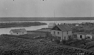 A view of the Hay River settlement from the Mission Boarding School, 1922
 -
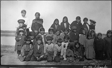 Children on their way to school in Hay River, 1931
 -
 St. Luke's English Church Mission School, Hay River, 1922
 -

.jpg)
,_1931_(13929401648).jpg)
,_1922_(14112742641).jpg)

Climate[edit]
Hay River has a subarctic climate (Dfc) with mild to warm summers and long cold winters.
| Climate data for Hay River (Hay River/Merlyn Carter Airport) WMO ID: 71935; coordinates 60°50′23″N 115°46′58″W / 60.83972°N 115.78278°W; elevation: 164.9 m (541 ft); 1981–2010 normals, extremes 1893–present[a] | |||||||||||||
|---|---|---|---|---|---|---|---|---|---|---|---|---|---|
| Month | Jan | Feb | Mar | Apr | May | Jun | Jul | Aug | Sep | Oct | Nov | Dec | Year |
| Record high humidex | 10.6 | 12.9 | 14.6 | 25.8 | 31.1 | 35.1 | 44.6 | 39.8 | 32.2 | 25.4 | 12.8 | 11.2 | 44.6 |
| Record high °C (°F) | 10.7 (51.3) | 13.9 (57.0) | 15.6 (60.1) | 26.0 (78.8) | 33.3 (91.9) | 34.0 (93.2) | 35.6 (96.1) | 36.7 (98.1) | 31.7 (89.1) | 25.6 (78.1) | 15.0 (59.0) | 14.4 (57.9) | 36.7 (98.1) |
| Mean daily maximum °C (°F) | −17.3 (0.9) | −14.2 (6.4) | −7.8 (18.0) | 2.9 (37.2) | 10.7 (51.3) | 18.0 (64.4) | 21.2 (70.2) | 19.6 (67.3) | 13.2 (55.8) | 4.1 (39.4) | −7.7 (18.1) | −14.4 (6.1) | 2.4 (36.3) |
| Daily mean °C (°F) | −21.8 (−7.2) | −19.6 (−3.3) | −13.8 (7.2) | −2.7 (27.1) | 5.4 (41.7) | 12.5 (54.5) | 16.1 (61.0) | 14.6 (58.3) | 8.7 (47.7) | 0.5 (32.9) | −11.6 (11.1) | −18.8 (−1.8) | −2.5 (27.5) |
| Mean daily minimum °C (°F) | −26.2 (−15.2) | −24.9 (−12.8) | −19.8 (−3.6) | −8.1 (17.4) | 0.0 (32.0) | 7.0 (44.6) | 10.9 (51.6) | 9.5 (49.1) | 4.1 (39.4) | −3.2 (26.2) | −15.4 (4.3) | −23.1 (−9.6) | −7.4 (18.7) |
| Record low °C (°F) | −52.2 (−62.0) | −50.6 (−59.1) | −47.2 (−53.0) | −40.0 (−40.0) | −24.4 (−11.9) | −6.1 (21.0) | −1.7 (28.9) | −6.7 (19.9) | −15.6 (3.9) | −26.1 (−15.0) | −40.8 (−41.4) | −51.1 (−60.0) | −52.2 (−62.0) |
| Record low wind chill | −59 | −60 | −55 | −48 | −27 | −7 | 0 | 0 | −17 | −34 | −54 | −56 | −60 |
| Average precipitation mm (inches) | 16.4 (0.65) | 14.3 (0.56) | 14.4 (0.57) | 12.6 (0.50) | 23.3 (0.92) | 31.9 (1.26) | 43.0 (1.69) | 58.7 (2.31) | 44.6 (1.76) | 35.7 (1.41) | 24.8 (0.98) | 16.8 (0.66) | 336.4 (13.24) |
| Average rainfall mm (inches) | 0.1 (0.00) | 0.2 (0.01) | 0.2 (0.01) | 4.3 (0.17) | 18.0 (0.71) | 31.9 (1.26) | 43.0 (1.69) | 58.7 (2.31) | 43.0 (1.69) | 16.8 (0.66) | 0.9 (0.04) | 0.3 (0.01) | 217.4 (8.56) |
| Average snowfall cm (inches) | 19.2 (7.6) | 16.9 (6.7) | 16.4 (6.5) | 8.7 (3.4) | 5.2 (2.0) | 0.1 (0.0) | 0.0 (0.0) | 0.0 (0.0) | 1.5 (0.6) | 19.9 (7.8) | 30.4 (12.0) | 20.7 (8.1) | 138.9 (54.7) |
| Average precipitation days (≥ 0.2 mm) | 11.3 | 9.7 | 8.5 | 5.0 | 8.0 | 8.8 | 9.9 | 11.3 | 12.2 | 12.6 | 14.2 | 11.4 | 122.8 |
| Average rainy days (≥ 0.2 mm) | 0.1 | 0.2 | 0.2 | 2.0 | 6.7 | 8.8 | 9.9 | 11.3 | 11.9 | 6.2 | 1.0 | 0.6 | 58.9 |
| Average snowy days (≥ 0.2 cm) | 12.0 | 10.1 | 8.7 | 3.7 | 1.8 | 0.1 | 0.0 | 0.0 | 0.8 | 8.1 | 14.5 | 12.4 | 72.2 |
| Average relative humidity (%) (at 15:00) | 69.2 | 66.3 | 61.3 | 60.2 | 55.0 | 54.4 | 57.6 | 59.9 | 62.5 | 70.6 | 78.0 | 73.7 | 64.0 |
| Source: Environment and Climate Change Canada[19][20][21][22][23][24][25][26][27][28][29][30][31][32][33][34] | |||||||||||||
- ^ Climate data was recorded at Hay River from September 1893 to June 1943 and at Hay River Airport from April 1943 to present.
Demographics[edit]
|
| |||||||||||||||||||||||||||||||||||||||||||||||||||||||||
| Sources: NWT Bureau of Statistics (2001 - 2012),[35] NWT Bureau of Statistics (2006 - 2017)[6] | ||||||||||||||||||||||||||||||||||||||||||||||||||||||||||
In the 2021 Census of Population conducted by Statistics Canada, Hay River Dene 1 had a population of 259 living in 90 of its 116 total private dwellings, a change of -16.2% from its 2016 population of 309. With a land area of 134 km2 (52 sq mi), it had a population density of 1.9/km2 (5.0/sq mi) in 2021.[36]
Arts and culture[edit]
Hay River Reserve is the setting for a children's story called Smelly Socks. The book was written by Robert Munsch and illustrated by Michael Martchenko. Munsch created the story based on a little girl named Tina whom he met while visiting the reserve in 1984. The illustrations in the book were based on actual pictures of Tina and the community provided by local multimedia artist Frederick Lepine.[37]
See also[edit]
References[edit]
- ^ "Hay River Dene 1". Geographical Names Data Base. Natural Resources Canada.
- ^ a b c "Census Profile, 2021 Census of Population Data table Hay River Dene 1, Indian reserve (IRI) Northwest Territories [Census subdivision]". Retrieved 8 March 2021.
- ^ "NWT Communities - Kátł'odeeche". Government of the Northwest Territories: Department of Municipal and Community Affairs. Retrieved 2017-10-29.
- ^ "Northwest Territories Official Community Names and Pronunciation Guide". Prince of Wales Northern Heritage Centre. Yellowknife: Education, Culture and Employment, Government of the Northwest Territories. Archived from the original on 2016-01-13. Retrieved 2016-01-13.
- ^ Canada Flight Supplement. Effective 0901Z 16 July 2020 to 0901Z 10 September 2020.
- ^ a b c Hay River Reserve - Statistical Profile at the GNWT
- ^ a b Census Profile, 2016 Census Hay River Dene 1, Indian reserve (Census subdivision), Northwest Territories and Northwest Territories (Territory)
- ^ a b List of Reserves/Settlements/Villages
- ^ Reserve, settlement or village details for Hay River Dene 1 Reserve at Indigenous and Northern Affairs Canada. Retrieved 8 March 2022.
- ^ Registered population of the K'atlodeeche First Nation First Nations at Indigenous and Northern Affairs Canada. Retrieved 8 March 2022.
- ^ Indian and Northern Affairs Canada
- ^ NWT Aboriginal Directory - South Slave Region
- ^ Chief Sunrise Education Centre
- ^ a b "History - Katl'odeeche (Hay River Dene Reserve)". Archived from the original on 2006-11-01. Retrieved 2007-03-05.
- ^ NWT Bureau of Statistics
- ^ Map of Vale Island
- ^ Traditional Lands
- ^ Hay River Mission Sites. Canadian Register of Historic Places. Retrieved 22 October 2013.
- ^ "Hay River A". Canadian Climate Normals 1981–2010. Environment and Climate Change Canada. 25 September 2013. Climate ID: 2202400. Retrieved 30 June 2016.
- ^ "Daily Data Report for December 1896". Canadian Climate Data. Environment and Climate Change Canada. 31 October 2011. Climate ID: 2202398. Retrieved 30 June 2016.
- ^ "Daily Data Report for September 1901". Canadian Climate Data. Environment and Climate Change Canada. 31 October 2011. Climate ID: 2202398. Retrieved 30 June 2016.
- ^ "Daily Data Report for September 1903". Canadian Climate Data. Environment and Climate Change Canada. 31 October 2011. Climate ID: 2202398. Retrieved 30 June 2016.
- ^ "Daily Data Report for January 1906". Canadian Climate Data. Environment and Climate Change Canada. 31 October 2011. Climate ID: 2202398. Retrieved 30 June 2016.
- ^ "Daily Data Report for February 1906". Canadian Climate Data. Environment and Climate Change Canada. 31 October 2011. Climate ID: 2202398. Retrieved 30 June 2016.
- ^ "Daily Data Report for July 1906". Canadian Climate Data. Environment and Climate Change Canada. 31 October 2011. Climate ID: 2202398. Retrieved 30 June 2016.
- ^ "Daily Data Report for May 1907". Canadian Climate Data. Environment and Climate Change Canada. 31 October 2011. Climate ID: 2202398. Retrieved 30 June 2016.
- ^ "Daily Data Report for April 1908". Canadian Climate Data. Environment and Climate Change Canada. 31 October 2011. Climate ID: 2202398. Retrieved 30 June 2016.
- ^ "Daily Data Report for October 1908". Canadian Climate Data. Environment and Climate Change Canada. 31 October 2011. Climate ID: 2202398. Retrieved 30 June 2016.
- ^ "Daily Data Report for December 1917". Canadian Climate Data. Environment and Climate Change Canada. 31 October 2011. Climate ID: 2202398. Retrieved 30 June 2016.
- ^ "Daily Data Report for June 1920". Canadian Climate Data. Environment and Climate Change Canada. 31 October 2011. Climate ID: 2202398. Retrieved 30 June 2016.
- ^ "Daily Data Report for October 1923". Canadian Climate Data. Environment and Climate Change Canada. 31 October 2011. Climate ID: 2202398. Retrieved 30 June 2016.
- ^ "Daily Data Report for July 1928". Canadian Climate Data. Environment and Climate Change Canada. 31 October 2011. Climate ID: 2202398. Retrieved 30 June 2016.
- ^ "Daily Data Report for August 1928". Canadian Climate Data. Environment and Climate Change Canada. 31 October 2011. Climate ID: 2202398. Retrieved 30 June 2016.
- ^ "Daily Data Report for March 1929". Canadian Climate Data. Environment and Climate Change Canada. 31 October 2011. Climate ID: 2202398. Retrieved 30 June 2016.
- ^ "Hay River Reserve - Statistical Profile (2001-2012)" (PDF). NWT Bureau of Statistics. Archived from the original (PDF) on 2014-02-01.
- ^ "Population and dwelling counts: Canada, provinces and territories, and census subdivisions (municipalities), Northwest Territories". Statistics Canada. February 9, 2022. Retrieved February 18, 2022.
- ^ "Smelly Socks | the Official Website of Robert Munsch".
| Ethnolinguistic groups | |||||||||||||||||
|---|---|---|---|---|---|---|---|---|---|---|---|---|---|---|---|---|---|
| Treaties and land claims | |||||||||||||||||
| Regional councils and community governments |
| ||||||||||||||||