
 French
 Deutsch
File:NPS grand-canyon-regional-map.jpg

Size of this preview: 649 × 600 pixels. Other resolutions: 260 × 240 pixels | 520 × 480 pixels | 831 × 768 pixels | 1,196 × 1,105 pixels.
Original file (1,196 × 1,105 pixels, file size: 207 KB, MIME type: image/jpeg)
| This is a file from the Wikimedia Commons. Information from its description page there is shown below. Commons is a freely licensed media file repository. You can help. |
Summary
| Description | English: Need to zoom out? Here’s a map of roads near Grand Canyon, showing driving directions between the rims or to Las Vegas. |
| Date | |
| Source | U.S. National Park Service (http://npmaps.com/wp-content/uploads/grand-canyon-regional-map.jpg) |
| Author | U.S. National Park Service, restoration/cleanup by Matt Holly |
| Other versions | 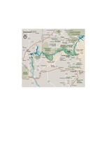 |
Licensing
| This image or media file contains material based on a work of a National Park Service employee, created as part of that person's official duties. As a work of the U.S. federal government, such work is in the public domain in the United States. See the NPS website and NPS copyright policy for more information. |
File history
Click on a date/time to view the file as it appeared at that time.
| Date/Time | Thumbnail | Dimensions | User | Comment | |
|---|---|---|---|---|---|
| current | 23:15, 16 May 2017 | | 1,196 × 1,105 (207 KB) | RKBot | =={{int:filedesc}}== {{Information |description= {{en|1=Need to zoom out? Here’s a map of roads near Grand Canyon, showing driving directions between the rims or to Las Vegas.}} |date= 2013-10-25 |source= U.S. National Park Service (http://npmaps.com... |
File usage
The following pages on the English Wikipedia use this file (pages on other projects are not listed):
Global file usage
The following other wikis use this file:
- Usage on gl.wikipedia.org
- Usage on is.wikipedia.org
- Usage on mr.wikipedia.org
- Usage on vi.wikipedia.org