
 French
 Deutsch
File:Mapa Triturus marmoratus.png
No higher resolution available.
Mapa_Triturus_marmoratus.png (567 × 401 pixels, file size: 66 KB, MIME type: image/png)
| This is a file from the Wikimedia Commons. Information from its description page there is shown below. Commons is a freely licensed media file repository. You can help. |
Summary
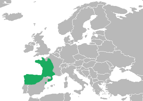
| Description | English: Range map of Triturus marmoratus. Español: Mapa de distribución del tritón jaspeado (Triturus marmoratus). |
| Date | |
| Source | Own work |
| Author | Osado |
Licensing
| I, the copyright holder of this work, release this work into the public domain. This applies worldwide. In some countries this may not be legally possible; if so: I grant anyone the right to use this work for any purpose, without any conditions, unless such conditions are required by law. |
File history
Click on a date/time to view the file as it appeared at that time.
| Date/Time | Thumbnail | Dimensions | User | Comment | |
|---|---|---|---|---|---|
| current | 20:02, 21 March 2018 | | 567 × 401 (66 KB) | Maphobbyist | Upload |
| 11:03, 4 March 2010 |  | 567 × 401 (72 KB) | Osado | {{Information |Description={{en|1=Range map of ''Triturus marmoratus''.}} {{es|1=Mapa de distribución del tritón jaspeado (''Triturus marmoratus'').}} |Source={{own}} |Author=Osado |Date=2010 |Permission= |other_versions= }} [http://www.i |
File usage
The following pages on the English Wikipedia use this file (pages on other projects are not listed):
Global file usage
The following other wikis use this file:
- Usage on ca.wikipedia.org
- Usage on ceb.wikipedia.org
- Usage on eo.wikipedia.org
- Usage on es.wikipedia.org
- Usage on fr.wikipedia.org
- Usage on gl.wikipedia.org
- Usage on it.wikipedia.org
- Usage on ko.wikipedia.org
- Usage on nv.wikipedia.org
- Usage on pt.wikipedia.org
- Usage on ru.wikipedia.org
- Usage on uk.wikipedia.org
- Usage on vi.wikipedia.org
- Usage on zh.wikipedia.org