
 French
 Deutsch
File:Gaza strip may 2005.jpg

Size of this preview: 560 × 599 pixels. Other resolutions: 224 × 240 pixels | 448 × 480 pixels | 717 × 768 pixels | 957 × 1,024 pixels | 2,398 × 2,567 pixels.
Original file (2,398 × 2,567 pixels, file size: 1.37 MB, MIME type: image/jpeg)
| This is a file from the Wikimedia Commons. Information from its description page there is shown below. Commons is a freely licensed media file repository. You can help. |
Summary
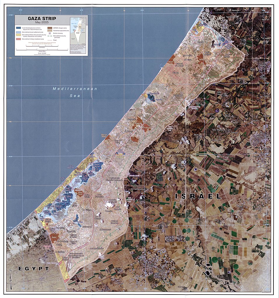
Map is linked from http://www.lib.utexas.edu/maps/gazastrip.html - It says "The following maps were produced by the U.S. Central Intelligence Agency unless otherwise noted."
Map: http://www.lib.utexas.edu/maps/middle_east_and_asia/gaza_strip_may_2005.jpg
Scale 1:65,000
.jpg)
.jpg)
.jpg)
.jpg)
Licensing
| This work is from the Library of Congress. According to the library, there are no known copyright restrictions on the use of this work. |  |
File history
Click on a date/time to view the file as it appeared at that time.
| Date/Time | Thumbnail | Dimensions | User | Comment | |
|---|---|---|---|---|---|
| current | 01:51, 27 July 2007 | | 2,398 × 2,567 (1.37 MB) | Timeshifter | Map is linked from http://www.lib.utexas.edu/maps/gazastrip.html - It says "The following maps were produced by the U.S. Central Intelligence Agency unless otherwise noted." Map: http://www.lib.utexas.edu/maps/middle_east_and_asia/gaza_strip_may_2005.jpg |
File usage
The following pages on the English Wikipedia use this file (pages on other projects are not listed):
Global file usage
The following other wikis use this file:
- Usage on ar.wikipedia.org
- Usage on cs.wikipedia.org
- Usage on da.wikipedia.org
- Usage on de.wikipedia.org
- Usage on de.wikinews.org
- Usage on en.wikinews.org
- Usage on eo.wikipedia.org
- Usage on es.wikipedia.org
- Usage on fa.wikipedia.org
- Usage on fi.wikipedia.org
- Usage on gd.wikipedia.org
- Usage on gl.wikipedia.org
- Usage on he.wikipedia.org
- Usage on id.wikipedia.org
- Usage on it.wikinews.org
- Usage on ja.wikipedia.org
- Usage on jv.wikipedia.org
- Usage on ko.wikipedia.org
- Usage on nn.wikipedia.org
- Usage on no.wikipedia.org
- Usage on pl.wikipedia.org
- Usage on pl.wikinews.org
- Usage on pt.wikipedia.org
- Usage on sv.wikinews.org
- Usage on www.wikidata.org
- Usage on zh.wikipedia.org