
 French
 Deutsch
File:Dixie Highway Map.png
Size of this preview: 215 × 599 pixels. Other resolutions: 86 × 240 pixels | 565 × 1,575 pixels.
Original file (565 × 1,575 pixels, file size: 353 KB, MIME type: image/png)
| This is a file from the Wikimedia Commons. Information from its description page there is shown below. Commons is a freely licensed media file repository. You can help. |
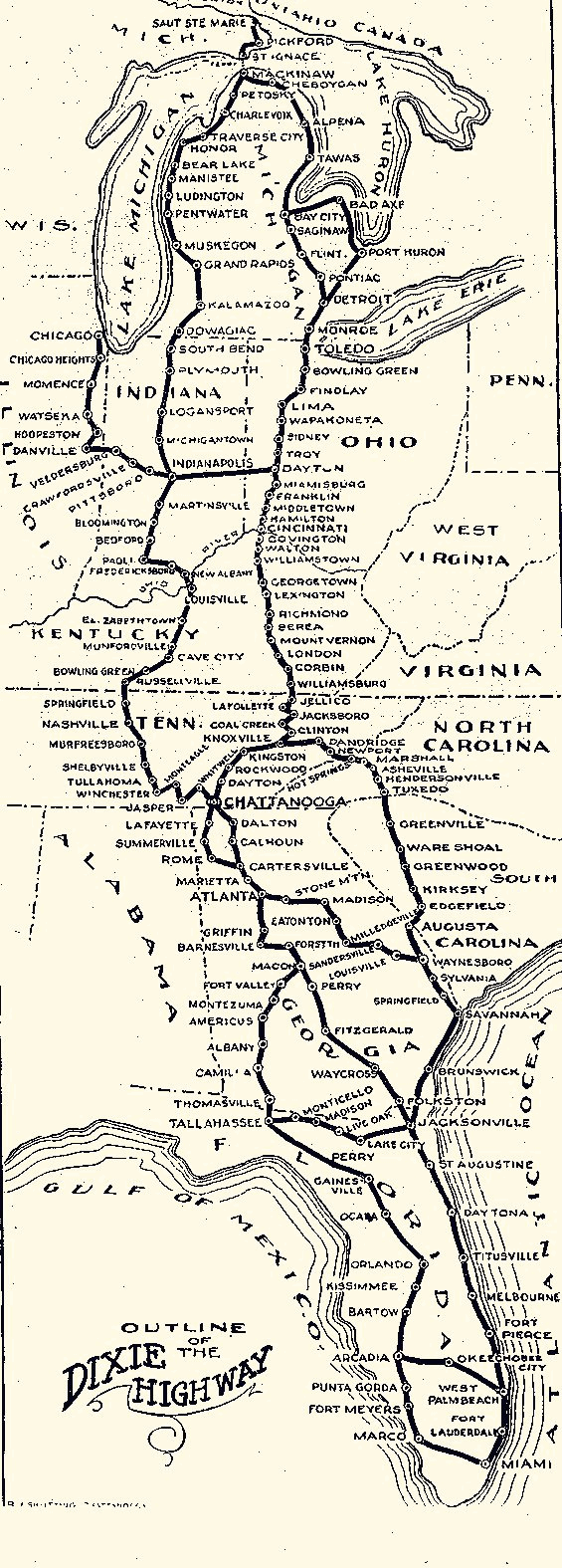
| Description | English: Map of the Dixie Highway |
| Date | (UTC) |
| Source | |
| Author |
|
| This is a retouched picture, which means that it has been digitally altered from its original version. Modifications: Converted to grayscale and to PNG format. The original can be viewed here: Dixie Highway Map.gif:
|
This media file is in the public domain in the United States. This applies to U.S. works where the copyright has expired, often because its first publication occurred prior to January 1, 1929, and if not then due to lack of notice or renewal. See this page for further explanation. |  | |
 | This image might not be in the public domain outside of the United States; this especially applies in the countries and areas that do not apply the rule of the shorter term for US works, such as Canada, Mainland China (not Hong Kong or Macao), Germany, Mexico, and Switzerland. The creator and year of publication are essential information and must be provided. See Wikipedia:Public domain and Wikipedia:Copyrights for more details. |
Original upload log
This image is a derivative work of the following images:
- File:Dixie_Highway_Map.gif licensed with PD-US
- 2009-01-31T16:12:47Z Tbook 565x1575 (45441 Bytes) {{Information |Description={{en|1=Map of the Dixie Highway}} |Source=Village of Homewood Heritage Committee |Author=Village of Homewood Heritage Committee |Date=1915 |Permission= |other_versions= }} [[Category:Maps]]
Uploaded with derivativeFX
File history
Click on a date/time to view the file as it appeared at that time.
| Date/Time | Thumbnail | Dimensions | User | Comment | |
|---|---|---|---|---|---|
| current | 17:18, 13 September 2010 | 565 × 1,575 (353 KB) | Burpelson AFB | {{Information |Description={{en|1=Map of the Dixie Highway}} |Source=*File:Dixie_Highway_Map.gif |Date=2010-09-13 17:17 (UTC) |Author=*File:Dixie_Highway_Map.gif: Dixie Highway Association *derivative work: ~~~ |Permission= |other_versions= }} |
File usage
The following pages on the English Wikipedia use this file (pages on other projects are not listed):
Global file usage
The following other wikis use this file:
- Usage on af.wikipedia.org
- Usage on www.wikidata.org