
 French
 Deutsch
File:Dinaric Alps subdivisions-fr.svg

Size of this PNG preview of this SVG file: 741 × 600 pixels. Other resolutions: 297 × 240 pixels | 593 × 480 pixels | 949 × 768 pixels | 1,265 × 1,024 pixels | 2,530 × 2,048 pixels | 1,857 × 1,503 pixels.
Original file (SVG file, nominally 1,857 × 1,503 pixels, file size: 3.5 MB)
| This is a file from the Wikimedia Commons. Information from its description page there is shown below. Commons is a freely licensed media file repository. You can help. |
Summary
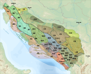
| Description | English: Geo-morphological and structural subdivisions map by of Dinaric Alps Français : Carte des subdivisions géo-morphologiques et structurelles de la chaîne des Alpes Dinariques :
| ||
| Date | |||
| Source | travail personnel (own work). Sources :
| ||
| Author | Sémhur | ||
| Other versions | |||
| Attribution (required by the license) | © Sémhur / Wikimedia Commons / | ||
| SVG | W3C-validity not checked.
| ||
| Graphic Lab |

| Camera location | | View this and other nearby images on: OpenStreetMap |
|---|
Licensing
I, the copyright holder of this work, hereby publish it under the following licenses:
| Copyleft: This work of art is free; you can redistribute it and/or modify it according to terms of the Free Art License. You will find a specimen of this license on the Copyleft Attitude site as well as on other sites. |
This file is licensed under the Creative Commons Attribution-Share Alike 4.0 International, 3.0 Unported, 2.5 Generic, 2.0 Generic and 1.0 Generic license.
- You are free:
- to share – to copy, distribute and transmit the work
- to remix – to adapt the work
- Under the following conditions:
- attribution – You must give appropriate credit, provide a link to the license, and indicate if changes were made. You may do so in any reasonable manner, but not in any way that suggests the licensor endorses you or your use.
- share alike – If you remix, transform, or build upon the material, you must distribute your contributions under the same or compatible license as the original.
You may select the license of your choice.
File history
Click on a date/time to view the file as it appeared at that time.
| Date/Time | Thumbnail | Dimensions | User | Comment | |
|---|---|---|---|---|---|
| current | 21:37, 29 November 2008 | | 1,857 × 1,503 (3.5 MB) | Sémhur | Renumérotation + capitales |
| 10:28, 29 November 2008 |  | 1,857 × 1,503 (3.48 MB) | Sémhur | == Description == {{Information |Description= {{en|1=Geo-morphological and structural subdivisions map by of Dinaric Alps, in French.}} {{fr|1=Carte des subdivisions géo-morphologiques et structurelles de la chaîne des [[:fr:Alpes D |
File usage
The following pages on the English Wikipedia use this file (pages on other projects are not listed):
Global file usage
The following other wikis use this file:
- Usage on bg.wikipedia.org
- Usage on bs.wikipedia.org
- Usage on da.wikipedia.org
- Usage on de.wikipedia.org
- Usage on eu.wikipedia.org
- Usage on fr.wikipedia.org
- Alpes dinariques
- Durmitor
- Dinara
- Bjelasica
- Prokletije
- Velebit (massif)
- Zlatibor (montagne)
- Plateau du Karst
- Gorjanci/Žumberak
- Zlatar (montagne)
- Lička Plješivica
- Mala Kapela
- Prenj
- Velika Kapela
- Zelengora
- Monts Morača
- Monts Kučka krajina
- Komovi
- Sinjajevina
- Wikipédia:Atelier graphique/Cartes/Archives/février 2009
- Usage on it.wikipedia.org
- Usage on lt.wikipedia.org
- Usage on no.wikipedia.org
- Usage on pl.wikipedia.org
- Usage on sk.wikipedia.org
- Usage on sl.wikipedia.org
- Usage on sq.wikipedia.org
- Usage on sr.wikipedia.org
- Usage on sv.wikipedia.org
View more global usage of this file.