
 French
 Deutsch
File:Despotate of Morea 1450.svg

Size of this PNG preview of this SVG file: 643 × 599 pixels. Other resolutions: 258 × 240 pixels | 515 × 480 pixels | 824 × 768 pixels | 1,099 × 1,024 pixels | 2,198 × 2,048 pixels | 1,303 × 1,214 pixels.
Original file (SVG file, nominally 1,303 × 1,214 pixels, file size: 208 KB)
| This is a file from the Wikimedia Commons. Information from its description page there is shown below. Commons is a freely licensed media file repository. You can help. |
Summary
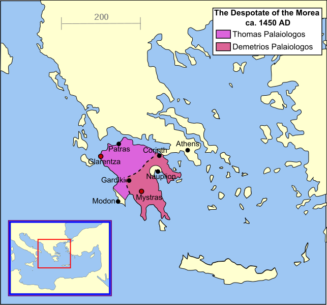
| Description | English: A map of the Despotate of the Morea in the year 1450. |
| Date | |
| Source | Own work |
| Author | MapMaster |
| Other versions | []
|


References
- Shepherd's map of the Ottoman Empire, 1451 - 1481.[dead link]
- Vakalopoulos, Apostolos E. Ιστορία του νέου ελληνισμού, Τόμος Α′: Αρχές και διαμόρφωσή του (Έκδοση Β′) [History of modern Hellenism, Volume I: Its origins and formation (2nd Edition)] Thessaloniki 1974, p. 343
- Bjorklund, Oddvar; Holmboe, Haakon; Rohr, Anders (1970) Historical Atlas of the World, Barnes & Noble, NY, SBN: 389-00253-4.
- Matthew, Donald, (1983), Atlas of Medieval Europe, Checkmark Books, New York.
- Image:Europe in 1430.PNG
See also
derivative works
Derivative works of this file: Despotate of Morea 1450 es.svg
Licensing
I, the copyright holder of this work, hereby publish it under the following licenses:
 | Permission is granted to copy, distribute and/or modify this document under the terms of the GNU Free Documentation License, Version 1.2 or any later version published by the Free Software Foundation; with no Invariant Sections, no Front-Cover Texts, and no Back-Cover Texts. A copy of the license is included in the section entitled GNU Free Documentation License. |
| This file is licensed under the Creative Commons Attribution-Share Alike 3.0 Unported license. | ||
| ||
| This licensing tag was added to this file as part of the GFDL licensing update. |
This file is licensed under the Creative Commons Attribution-Share Alike 2.5 Generic license.
- You are free:
- to share – to copy, distribute and transmit the work
- to remix – to adapt the work
- Under the following conditions:
- attribution – You must give appropriate credit, provide a link to the license, and indicate if changes were made. You may do so in any reasonable manner, but not in any way that suggests the licensor endorses you or your use.
- share alike – If you remix, transform, or build upon the material, you must distribute your contributions under the same or compatible license as the original.
You may select the license of your choice.
File history
Click on a date/time to view the file as it appeared at that time.
| Date/Time | Thumbnail | Dimensions | User | Comment | |
|---|---|---|---|---|---|
| current | 10:03, 27 June 2011 | | 1,303 × 1,214 (208 KB) | Cplakidas | improved version, showing major towns as well as the division of the Despotate between the brothers Tomas and Demetrios after 1450 |
| 02:04, 17 September 2007 |  | 1,303 × 1,214 (131 KB) | MapMaster | border changes based on discussion with Alekkas (see Image talk:Eastern Mediterranean 1450 .svg) | |
| 13:31, 14 April 2007 |  | 1,303 × 1,214 (133 KB) | MapMaster | Better colour | |
| 05:30, 14 April 2007 |  | 1,303 × 1,214 (134 KB) | MapMaster | A "locator" (text- and language-free) map of the Despotate of Morea in the year 1450. Category:Maps of the history of Greece |
File usage
The following pages on the English Wikipedia use this file (pages on other projects are not listed):
Global file usage
The following other wikis use this file:
- Usage on als.wikipedia.org
- Usage on az.wikipedia.org
- Usage on be.wikipedia.org
- Usage on bg.wikipedia.org
- Usage on ca.wikipedia.org
- Usage on cs.wikipedia.org
- Usage on de.wikipedia.org
- Usage on el.wikipedia.org
- Usage on eo.wikipedia.org
- Usage on et.wikipedia.org
- Usage on fa.wikipedia.org
- Usage on fi.wikipedia.org
- Usage on fr.wikipedia.org
- Usage on gl.wikipedia.org
- Usage on he.wikipedia.org
- Usage on hu.wikipedia.org
- Usage on hy.wikipedia.org
- Usage on id.wikipedia.org
- Usage on ja.wikipedia.org
- Usage on ka.wikipedia.org
- Usage on lt.wikipedia.org
- Usage on mk.wikipedia.org
- Usage on pl.wikipedia.org
- Usage on ro.wikipedia.org
- Usage on ru.wikipedia.org
View more global usage of this file.