
 French
 Deutsch
File:Atilax paludinosus range map.png
No higher resolution available.
Atilax_paludinosus_range_map.png (456 × 473 pixels, file size: 18 KB, MIME type: image/png)
| This is a file from the Wikimedia Commons. Information from its description page there is shown below. Commons is a freely licensed media file repository. You can help. |
Summary
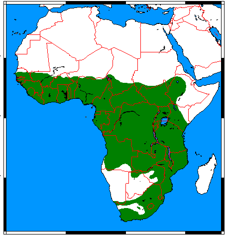
| Description | English: Range map for Marsh Mongoose (Atilax paludinosus), made by me with help of www.aquarius.geomar.de, Map depending on the range map at IUCN red list. |
| Date | |
| Source | Own work |
| Author | Udo Schröter |
 | This biogeographical map image could be re-created using vector graphics as an SVG file. This has several advantages; see Commons:Media for cleanup for more information. If an SVG form of this image is available, please upload it and afterwards replace this template with {{vector version available|new image name}}. It is recommended to name the SVG file “Atilax paludinosus range map.svg”—then the template Vector version available (or Vva) does not need the new image name parameter. |
Licensing
I, the copyright holder of this work, hereby publish it under the following licenses:
This file is licensed under the Creative Commons Attribution-Share Alike 3.0 Unported, 2.5 Generic, 2.0 Generic and 1.0 Generic license.
- You are free:
- to share – to copy, distribute and transmit the work
- to remix – to adapt the work
- Under the following conditions:
- attribution – You must give appropriate credit, provide a link to the license, and indicate if changes were made. You may do so in any reasonable manner, but not in any way that suggests the licensor endorses you or your use.
- share alike – If you remix, transform, or build upon the material, you must distribute your contributions under the same or compatible license as the original.
 | Permission is granted to copy, distribute and/or modify this document under the terms of the GNU Free Documentation License, Version 1.2 or any later version published by the Free Software Foundation; with no Invariant Sections, no Front-Cover Texts, and no Back-Cover Texts. A copy of the license is included in the section entitled GNU Free Documentation License. |
You may select the license of your choice.
File history
Click on a date/time to view the file as it appeared at that time.
| Date/Time | Thumbnail | Dimensions | User | Comment | |
|---|---|---|---|---|---|
| current | 01:07, 18 March 2018 | | 456 × 473 (18 KB) | Maphobbyist | Border updates: South Sudan, Eritrea and Lebanon added, Yemen united, the former Neutral Zone and Waalvisbai removed, and all border gaps filled. |
| 22:51, 16 March 2018 |  | 333 × 363 (14 KB) | Maphobbyist | South Sudan border | |
| 18:30, 28 July 2011 |  | 294 × 341 (19 KB) | Craig Pemberton | Crop to original size. | |
| 18:30, 28 July 2011 |  | 379 × 450 (25 KB) | Craig Pemberton | Normalize with other range maps for eventual combination in parent taxa. | |
| 13:50, 24 April 2009 |  | 456 × 473 (20 KB) | Nordelch | {{Information |Description={{en|1=Range map for Marsh Mongoose (''Atilax paludinosus''), made by me with help of [http://www.aquarius.geomar.de/omc_intro.html www.aquarius.geomar.de], Map depending on the [http://www.iucnredlist.org/details/41590 range ma |
File usage
The following pages on the English Wikipedia use this file (pages on other projects are not listed):
Global file usage
The following other wikis use this file:
- Usage on af.wikipedia.org
- Usage on ar.wikipedia.org
- Usage on arz.wikipedia.org
- Usage on avk.wikipedia.org
- Usage on azb.wikipedia.org
- Usage on bg.wikipedia.org
- Usage on br.wikipedia.org
- Usage on ca.wikipedia.org
- Usage on ceb.wikipedia.org
- Usage on de.wikipedia.org
- Usage on el.wikipedia.org
- Usage on es.wikipedia.org
- Usage on eu.wikipedia.org
- Usage on fa.wikipedia.org
- Usage on fr.wikipedia.org
- Usage on he.wikipedia.org
- Usage on hu.wikipedia.org
- Usage on id.wikipedia.org
- Usage on it.wikipedia.org
- Usage on ko.wikipedia.org
- Usage on mhr.wikipedia.org
- Usage on pl.wikipedia.org
- Usage on pnb.wikipedia.org
- Usage on ru.wikipedia.org
- Usage on sq.wikipedia.org
- Usage on sv.wikipedia.org
- Usage on tr.wikipedia.org
- Usage on uk.wikipedia.org
- Usage on vi.wikipedia.org
- Usage on www.wikidata.org
- Usage on zh.wikipedia.org