
 French
 Deutsch
File:Ancient Regions Mainland Greece.png
Size of this preview: 518 × 600 pixels. Other resolutions: 207 × 240 pixels | 414 × 480 pixels | 950 × 1,100 pixels.
Original file (950 × 1,100 pixels, file size: 666 KB, MIME type: image/png)
| This is a file from the Wikimedia Commons. Information from its description page there is shown below. Commons is a freely licensed media file repository. You can help. |
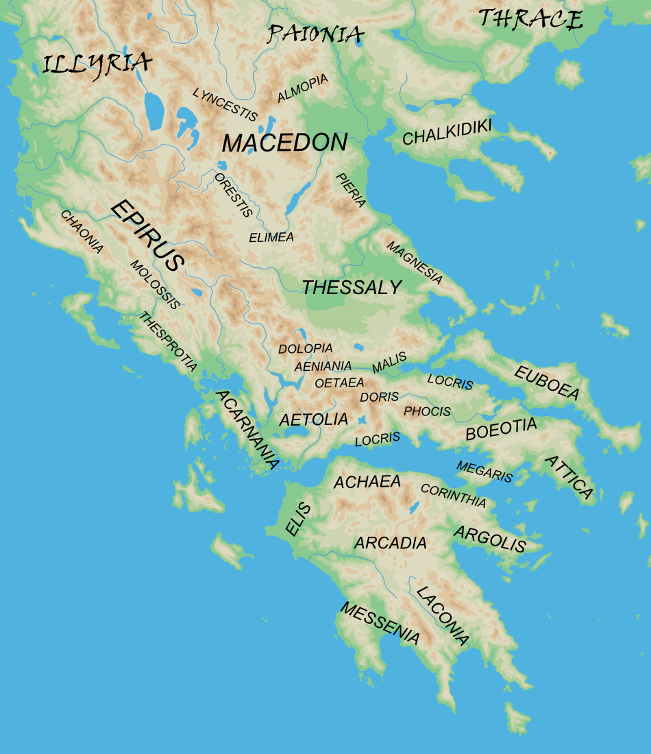
| Description | English: Map of the major regions of mainland Ancient Greece. |
| Date | (UTC) |
| Source |
|
| Author |
|
| Other versions | Derivative works of this file: Ancient Regions Epirus and Macedon.png
|


| This is a retouched picture, which means that it has been digitally altered from its original version. The original can be viewed here: Map greek sanctuaries-en.svg:
|
I, the copyright holder of this work, hereby publish it under the following licenses:
This file is licensed under the Creative Commons Attribution-Share Alike 2.5 Generic license.
- You are free:
- to share – to copy, distribute and transmit the work
- to remix – to adapt the work
- Under the following conditions:
- attribution – You must give appropriate credit, provide a link to the license, and indicate if changes were made. You may do so in any reasonable manner, but not in any way that suggests the licensor endorses you or your use.
- share alike – If you remix, transform, or build upon the material, you must distribute your contributions under the same or compatible license as the original.
| This file is licensed under the Creative Commons Attribution-Share Alike 3.0 Unported license. | ||
| ||
| This licensing tag was added to this file as part of the GFDL licensing update. |
 | Permission is granted to copy, distribute and/or modify this document under the terms of the GNU Free Documentation License, Version 1.2 or any later version published by the Free Software Foundation; with no Invariant Sections, no Front-Cover Texts, and no Back-Cover Texts. A copy of the license is included in the section entitled GNU Free Documentation License. |
You may select the license of your choice.
Original upload log
This image is a derivative work of the following images:
- File:Map_greek_sanctuaries-en.svg licensed with Cc-by-sa-2.5, Cc-by-sa-3.0-migrated, GFDL
- 2007-02-26T22:21:53Z Bibi Saint-Pol 993x793 (3420463 Bytes) + libellés mers
- 2007-01-24T15:08:47Z Bibi Saint-Pol 993x793 (3388755 Bytes) + libellés merstypotypo•
- 2007-01-21T14:26:03Z Bibi Saint-Pol 993x793 (3388746 Bytes) + libellés merstypo
- 2007-01-10T03:25:02Z Bibi Saint-Pol 993x793 (3388746 Bytes) Didymes oracle
- 2007-01-08T00:07:20Z Bibi Saint-Pol 993x793 (3386646 Bytes) typo
- 2007-01-08T00:03:06Z Bibi Saint-Pol 993x793 (3386645 Bytes) + libellés mers+ libellés mers
- 2007-01-07T23:49:46Z Bibi Saint-Pol 993x793 (3379344 Bytes) {{Information |Description={{fr|1=[[:fr:Ariane Ascaride|Ariane Ascaride]], [[:fr:Juliette Binoche|Juliette Binoche]], [[:fr:Alain Resnais|Alain Resnais]] et [[:fr:Agnès Jaoui|Agnès Jaoui]] à la cérémonie des césars}} |Stypo
Uploaded with derivativeFX
File history
Click on a date/time to view the file as it appeared at that time.
| Date/Time | Thumbnail | Dimensions | User | Comment | |
|---|---|---|---|---|---|
| current | 08:16, 24 March 2010 | | 950 × 1,100 (666 KB) | MinisterForBadTimes | Typo corrected |
| 21:46, 3 March 2010 |  | 950 × 1,100 (666 KB) | MinisterForBadTimes | {{Information |Description={{en|Map of the major regions of mainland Ancient Greece.}} |Source=*blank map from File:Map_greek_sanctuaries-en.svg *Geographical information based on public domain map of Greece, from the Perry-Castañeda Library Map Co |
File usage
The following pages on the English Wikipedia use this file (pages on other projects are not listed):
Global file usage
The following other wikis use this file:
- Usage on ar.wikipedia.org
- Usage on bcl.wikipedia.org
- Usage on bg.wikipedia.org
- Usage on cs.wikipedia.org
- Usage on el.wikipedia.org
- Usage on en.wiktionary.org
- Usage on fi.wikipedia.org
- Usage on he.wikipedia.org
- Usage on it.wikipedia.org
- Usage on kk.wikipedia.org
- Usage on ku.wikipedia.org
- Usage on la.wikipedia.org
- Usage on lt.wikipedia.org
- Usage on mzn.wikipedia.org
- Usage on pl.wiktionary.org
- Usage on pt.wikipedia.org
- Usage on ro.wikipedia.org
- Usage on sl.wikipedia.org
- Usage on sq.wikipedia.org
- Usage on sr.wikipedia.org
- Usage on vi.wikipedia.org
- Usage on zh.wikipedia.org