
 French
 Deutsch
File:AMH-4680-NA Map of the area around Menado.jpg

Original file (5,072 × 6,272 pixels, file size: 4.86 MB, MIME type: image/jpeg)
| This is a file from the Wikimedia Commons. Information from its description page there is shown below. Commons is a freely licensed media file repository. You can help. |
Summary
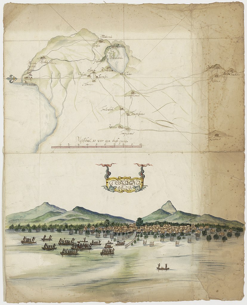
Nederlands: Kaart van de omgeving van Menado English: Map of the area around Menado Bahasa Indonesia: Peta area sekitar Manado( | ||||||||||||||||||||||||
|---|---|---|---|---|---|---|---|---|---|---|---|---|---|---|---|---|---|---|---|---|---|---|---|---|
| Author | ||||||||||||||||||||||||
| Title | Nederlands: Kaart van de omgeving van Menado English: Map of the area around Menado Bahasa Indonesia: Peta area sekitar Manado | |||||||||||||||||||||||
| Description | Nederlands: Titel catalogus Leupe (NA): Kaartje van de Manahassa. Bij Manado is een Nederlandse vlag getekend. Hoort bij het dagregister van gouverneur Padtbrugge in VOC 1345. De achterkant is ter versteviging helemaal beplakt; De randen zijn bruin, zo te zien staken die uit in de band OBP. Notities verso: N 910 [in potlood] [eventuele verdere notities verloren gegaan door de versteviging].English: According to the Leupe catalogue (NA), the original title reads: Kaartje van de Manahassa. The Dutch flag is depicted alongside Manado. Forms part of the daily register kept by Governor Padtbrugge in VOC 1345. The chart has been reinforced at the back. Its edges are discoloured brown, it seems they stuck out of the OBP volume. Notes on reverse: N 910 [in pencil] [any other notes will have been lost as a result of the reinforcing layer].Bahasa Indonesia: Menurut katalog Leupe (NA), judul aslinya berbunyi: Kaartje van de Manahassa. Bendera Belanda digambarkan di samping Manado. Merupakan bagian dari daftar harian yang disimpan oleh Gubernur Padtbrugge di VOC 1345. Peta telah diperkuat di bagian belakang. Tepinya berubah warna menjadi cokelat, sepertinya menonjol keluar dari volume OBP. Catatan di belakang: N 910 [dengan pensil] [catatan lain akan hilang sebagai akibat dari lapisan penguat]. | |||||||||||||||||||||||
| Date | 1679 | |||||||||||||||||||||||
| Medium | Nederlands: ingekleurde tekening op papier English: coloured drawing on paper Bahasa Indonesia: gambar berwarna di atas kertas | |||||||||||||||||||||||
| Dimensions | height: 42 cm (16.5 in); width: 52 cm (20.4 in) | |||||||||||||||||||||||
| Collection |
| |||||||||||||||||||||||
| Accession number | NL-HaNA_4.VEL_1305 (old number: VEL1305) | |||||||||||||||||||||||
| Inscriptions | Tondano | |||||||||||||||||||||||
| Notes | English: Subjects: ship / vessel, survey / view, banderole / cartouche / ornamentation, Asians & Africans, chart / map / plan Nederlands: Onderwerpen: schip / vaartuig, overzicht / aanzicht, banderol / cartouche / versiering, Aziaten & Afrikanen, plattegrond / kaart English: Post: this image is related to a VOC trading post called Manado | |||||||||||||||||||||||
| Source/Photographer |
| |||||||||||||||||||||||
| Permission (Reusing this file) |
| |||||||||||||||||||||||

| Object location | | View this and other nearby images on: OpenStreetMap |
|---|
File history
Click on a date/time to view the file as it appeared at that time.
| Date/Time | Thumbnail | Dimensions | User | Comment | |
|---|---|---|---|---|---|
| current | 13:19, 12 December 2017 | | 5,072 × 6,272 (4.86 MB) | Timmietovenaar | Higher Resolution |
| 16:59, 10 June 2014 |  | 1,922 × 2,400 (778 KB) | HuskyBot | == {{int:filedesc}} == {{Artwork |title = {{nl|1=Kaart van de omgeving van Menado}} {{en|1=Map of the area around Menado}} |description = {{nl|1=Titel catalogus Leupe (NA): ''Kaartje van de Manahassa''. Bij Ma... |
File usage
Global file usage
The following other wikis use this file:
- Usage on nl.wikipedia.org