Файл:Breakup of Yugoslavia.gif – Уикипедия
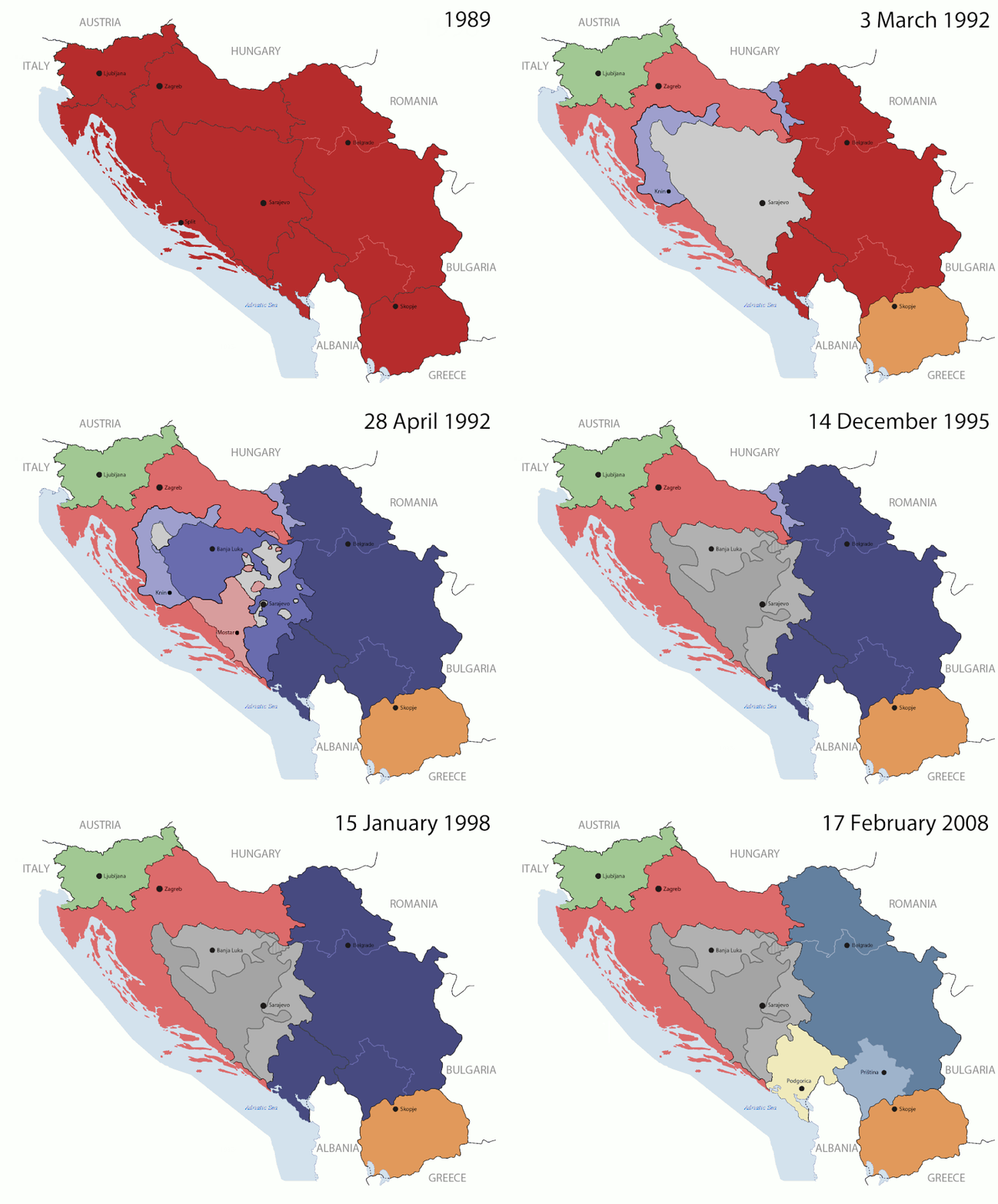
Оригинален файл(1545 × 1242 пиксела, големина на файла: 187 КБ, MIME-тип: image/gif, зациклен, 14 кадъра, 44 сек)

Емблемата на Общомедия Този файл е от Общомедия и може да се използва от други проекти.

Следва информация за файла, достъпна през оригиналната му описателна страница.

This image could be re-created using vector graphics as an SVG file. This has several advantages; see Commons:Media for cleanup for more information. If an SVG form of this image is available, please upload it and afterwards replace this template with {{vector version available|new image name}}. It is recommended to name the SVG file "Breakup of Yugoslavia.svg" - then the template Vector version available (or Vva) does not need the new image name parameter.

Резюме

Key:

Yugoslavia (1943–1992) SFR Yugoslavia
Croatia (1991–present) Croatia
Herzeg-Bosnia (1992–1994)
UNTAES (1996–1998)
Federal Republic of Yugoslavia / Serbia and Montenegro (1992–2006) Serbia and Montenegro
Republika Srpska (1992–present) Republika Srpska
Serbian Krajina (1991–1995/96)
Republic of Bosnia and Herzegovina (1992–1995)
Bosnia and Herzegovina (1998–present) Bosnia and Herzegovina
Western Bosnia (1993–1995)
Serbia (2006–present) Serbia
Kosovo (under UNMIK control 1999–present; declaration of independence 2008) Kosovo
Montenegro (2006–present) Montenegro
Macedonia (1991–present) Macedonia
Slovenia (1991–present) Slovenia


Описание

This is an animated GIF that shows the stages of the breakup of the SFR Yugoslavia in the 90's and 2000's. The map based off Morwen's map of the divisions of the SFRY, Which is licensed by the GFDL. The source for the dates of independence is the CIA World Factbook. These maps do not now show the Inter-Entity Boundary Line (IEBL) and/or the entities that are separated by it. The IEBL has been drawn based on this CIA map; the Brčko District has been drawn based on Image:BH municipality location.gif, by user:Ante Perkovic. I might add them in the future.

Since the original map was GFDL, this image is as well.

A map depicting Kosovo's final status is ready once it takes effect.


Changelog for versions 2/3:

Here are some changes in this new build of the map:

  • The Kosovo boundary has been given a shade of red instead of the previous UN blue since they are a province of Serbia under UNIMIK control.
  • Montenegro's color has been changed to a golden shade close to what's on the flag.
  • The IEBL and the Brčko District has been redrawn because I deleted the original map; the color for the Republika Srpska is lighter.
  • The dates are at the top left hand corner of the map instead of the bottom.
  • I have taken a new approach as to the boundaries. Each part of Yugoslavia now shows the boundary on the maps starting the year they broke away. I feel this change helps readers understand the breakup better.
  • The SFRY and the FRY are in different shades since the FRY was never accepted as the successor to the former by the UN.
  • The colors for the entities of BiH have been removed as to not confuse people into thinking that they are independent states. What remains is the IEBL with both entities in green.
  • The Kosovo boundary is finally in hash marks!
  • The Brčko District has been removed. The sale is too small to show accurately.

Changelog for version 4:

  • The map is larger!
  • The image has been rebuilt to include the eastern part of FYR Macedonia.
  • The image has been updated to take in Kosovo's new status.
  • The IEBL is now a darker line.
  • Montenegro, Kosovo, and FRY/SCG/Serbia have new colors!

Changelog for version 5:

  • Rebuilt
  • Larger map: size of base image
  • Accurate Inter-Entity Boundary Line
Дата 24 July 2006 (orginal upload date)
Източник Made by Hoshie; see above for more details on sources.
Автор Hoshie
други версии

Лицензиране

GNU head Предоставя се разрешение за копиране, разпространение и/или модификация на този документ според Лиценза за свободна документация на ГНУ, в своята версия 1.2 или някоя следваща версия, издадена от Фондацията за свободен софтуер; без непроменими раздели, без текст на предната подвързия и без текст на задната подвързия. Копие на този лиценз е приложено в раздела Лиценз за свободна документация на ГНУ.
w:bg:Криейтив Комънс
признание на авторството споделяне на споделеното
Този файл се разпространява под лиценз Криейтив Комънс Признание — Споделяне на споделеното 3.0.
Можете свободно:
  • да споделяте – да копирате, разпространявате и излъчвате произведението
  • да ремиксирате – да адаптирате произведението
Съгласно следните условия:
  • признание на авторството – Трябва да посочите авторството, да добавите връзка към лиценза и да посочите дали са правени промени. Можете да направите това по всякакъв разумен начин, но не и по начин, оставящ впечатлението, че същият/същите подкрепят вас или използването по някакъв начин на творбата от вас.
  • споделяне на споделеното – В случай, че промените, видоизмените или използвайки като основа произведението, го надградите, то полученото производно произведение може да се разпространява само съгласно условията на същия или съвместим лиценз с оригиналния такъв.
This licensing tag was added to this file as part of the GFDL licensing update.

Описания

Add a one-line explanation of what this file represents

Items portrayed in this file

изобразен обект

Някаква стойност без обект в Уикиданни

copyright status английски

copyrighted английски

MIME type английски

image/gif

checksum английски

05ca2aefea8406b809968643552d5095c847a42f

data size английски

191 625 Байт

1242 пиксел

1545 пиксел

История на файла

Избирането на дата/час ще покаже как е изглеждал файлът към онзи момент.

(най-нови | най-стари) Преглед (по-нови 10 | ) (10 | 20 | 50 | 100 | 250 | 500).
Дата/ЧасМиникартинкаРазмерПотребителКоментар
текуща07:40, 17 юли 2016Миникартинка на версията към 07:40, 17 юли 20161545 × 1242 (187 КБ)מפתח-רשימהReverted to version as of 17:22, 21 August 2015 (UTC)
17:22, 21 август 2015Миникартинка на версията към 17:22, 21 август 20151463 × 1158 (1,81 МБ)BraganzaReverted to version as of 03:57, 19 January 2010
17:22, 21 август 2015Миникартинка на версията към 17:22, 21 август 20151545 × 1242 (187 КБ)BraganzaReverted to version as of 01:02, 19 December 2011
17:15, 21 август 2015Миникартинка на версията към 17:15, 21 август 2015120 × 95 (3 КБ)Braganza03:57, 19. Jan. 2010
01:02, 19 декември 2011Миникартинка на версията към 01:02, 19 декември 20111545 × 1242 (187 КБ)DIREKTORAdded details
18:09, 27 юли 2011Миникартинка на версията към 18:09, 27 юли 20111545 × 1242 (170 КБ)DIREKTORSmall fixes
17:28, 27 юли 2011Миникартинка на версията към 17:28, 27 юли 20111545 × 1242 (171 КБ)DIREKTORAdded UNMIK
16:38, 27 юли 2011Миникартинка на версията към 16:38, 27 юли 20111545 × 1242 (165 КБ)DIREKTORDates for the last two frames.
12:10, 27 юли 2011Миникартинка на версията към 12:10, 27 юли 20111545 × 1242 (149 КБ)DIREKTORLighter shade for country names
16:59, 26 юли 2011Миникартинка на версията към 16:59, 26 юли 20111545 × 1242 (170 КБ)DIREKTORHigher res plus details
(най-нови | най-стари) Преглед (по-нови 10 | ) (10 | 20 | 50 | 100 | 250 | 500).

Следните 2 страници използват следния файл:

Глобално използване на файл

Този файл се използва от следните други уикита:

Преглед на глобалната употреба на файла.

Метаданни