 | Williamsbridge is a neighborhood geographically located in the north-central portion of the Bronx in New York City. Its boundaries, starting from the... 23 KB (2,356 words) - 10:30, 15 March 2024 |
 | location simply as "Gun Hill Road" (a nearby thoroughfare) rather than "Williamsbridge". Other neighborhood names have greater popularity. For example, Riverdale... 8 KB (884 words) - 15:35, 29 April 2024 |
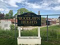 | estimated 22% of Woodlawn Heights and Williamsbridge residents lived in poverty, compared to 25% in all of the Bronx and 20% in all of New York City. One... 25 KB (2,467 words) - 10:31, 15 March 2024 |
an estimated 22% of Baychester and Williamsbridge residents lived in poverty, compared to 25% in all of the Bronx and 20% in all of New York City. One... 20 KB (2,025 words) - 11:10, 24 April 2024 |
 | Williamsbridge Oval is a park located in Norwood, Bronx, New York City. It is listed in the National Register of Historic Places. The Williamsbridge Oval... 6 KB (364 words) - 19:20, 9 October 2022 |
 | Park (Community District 11); Williamsbridge, Eastchester, Baychester, Edenwald and Wakefield (Community District 12). (Bronx Community District 10) City... 202 KB (21,203 words) - 03:57, 27 April 2024 |
 | Gun Hill Road station (IRT White Plains Road Line) (category Williamsbridge, Bronx) Avenue to East 219th Street–White Plains Road, providing the Bronx communities of Williamsbridge and Wakefield with access to rapid transit service. Service... 11 KB (758 words) - 17:26, 28 April 2024 |
 | an estimated 22% of Eastchester and Williamsbridge residents lived in poverty, compared to 25% in all of the Bronx and 20% in all of New York City. One... 26 KB (2,682 words) - 10:30, 15 March 2024 |
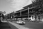
 | Westchester Square, and Williamsbridge. The East Bronx is less densely populated than the West Bronx. While the West Bronx is older and its underlying... 6 KB (631 words) - 02:48, 21 March 2024 |
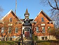
 | White Plains Road at 215th Street in Williamsbridge, Bronx, New York City, New York. The church served the Williamsbridge area along with a parish school on... 5 KB (533 words) - 14:22, 12 October 2023 |