 | The Wide Area Augmentation System (WAAS) is an air navigation aid developed by the Federal Aviation Administration to augment the Global Positioning System... 42 KB (4,012 words) - 20:23, 8 April 2024 |
the calculation process. Satellite-based augmentation systems (SBAS) support wide-area or regional augmentation through the use of additional satellite-broadcast... 14 KB (1,505 words) - 18:33, 18 March 2024 |
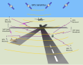
 | Positioning System (GPS) provides an alternative source of approach guidance for aircraft. In the US, the Wide Area Augmentation System (WAAS) has been... 52 KB (6,142 words) - 04:00, 6 March 2024 |
 | The local-area augmentation system (LAAS) is an all-weather aircraft landing system based on real-time differential correction of the GPS signal. Local... 12 KB (1,415 words) - 04:32, 6 March 2024 |
service to Wide Area Augmentation System (WAAS) in North America, European Geostationary Navigation Overlay Service (EGNOS) in Europe and System for Differential... 3 KB (228 words) - 20:19, 24 October 2023 |
 | European Geostationary Navigation Overlay Service (redirect from European geostationary navigation overlay system) service is provided in North America by the Wide Area Augmentation System (WAAS), in Russia by the System for Differential Corrections and Monitoring... 18 KB (1,734 words) - 16:54, 30 December 2023 |
 | Satellite navigation (redirect from Satellite Navigation System) or Ground Based Augmentation Systems (GBAS). In the United States, the satellite-based component is the Wide Area Augmentation System (WAAS); in Europe... 42 KB (4,396 words) - 04:51, 15 April 2024 |
 | operation is similar to that of, e.g. Wide Area Augmentation System. It transmits on L1. The CLAS (Centimeter Level Augmentation) service provides high-precision... 22 KB (1,833 words) - 12:45, 4 March 2024 |
for the Wide Area Augmentation System, an air navigation aid to supplement GPS. WAAS, Waas, or WaaS may also refer to: Waas (surname) Wide area application... 542 bytes (99 words) - 18:40, 1 December 2020 |
 | equipment Electronics technician Global Positioning System VHF omnidirectional range Wide Area Augmentation System Rockwell International (July 7, 1992). "Aircraft... 14 KB (1,647 words) - 14:13, 21 March 2024 |