 | The United Nations geoscheme for Oceania is an internal tool created and used by the UN's Statistics Division (UNSD) for the specific purpose of UN statistics... 10 KB (301 words) - 12:05, 16 February 2024 |
 | an alphabetical list of subregions in the United Nations geoscheme for Europe, created by the United Nations Statistics Division (UNSD). The scheme subdivides... 4 KB (249 words) - 04:02, 17 February 2024 |
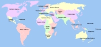 | The United Nations geoscheme is a system which divides 248 countries and territories in the world into six continental regions, 22 geographical subregions... 7 KB (535 words) - 04:42, 27 April 2024 |
 | of subregions in the United Nations geoscheme for Africa, used by the United Nations and maintained by the UNSD department for statistical purposes.... 4 KB (238 words) - 13:49, 18 April 2024 |
 | The United Nations geoscheme for Asia is an internal tool created and used by the United Nations, maintained by the United Nations Statistics Division... 6 KB (582 words) - 02:06, 4 May 2024 |
 | The United Nations geoscheme for the Americas is an internal tool created and used by the UN's Statistics Division (UNSD) for the specific purpose of... 5 KB (321 words) - 10:41, 26 April 2024 |
This is a list of countries and territories by the United Nations geoscheme, including 193 UN member states, two UN observer states (the Holy See and the... 85 KB (586 words) - 22:37, 3 May 2024 |
Outlying Oceania is the name used in the Unicode Common Locale Data Repository for territories that are supplemented into the United Nations geoscheme for Oceania... 1 KB (133 words) - 20:54, 13 December 2023 |
List of political parties by region (redirect from Lists of political parties by United Nations geoscheme) parties are appropriately detailed in separate articles dedicated to each nation. List of political parties in Africa by country List of political parties... 3 KB (332 words) - 01:52, 4 December 2023 |
 | Oceania Oceania (journal) Oceanic cuisine Indigenous peoples of Oceania Pacific Islander Pacific Union Pacific Community United Nations geoscheme for... 342 KB (30,576 words) - 12:14, 30 April 2024 |