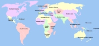
 | The United Nations geoscheme is a system which divides 248 countries and territories in the world into six continental regions, 22 geographical subregions... 7 KB (535 words) - 04:42, 27 April 2024 |
 | an alphabetical list of subregions in the United Nations geoscheme for Africa, used by the United Nations and maintained by the UNSD department for statistical... 4 KB (238 words) - 13:49, 18 April 2024 |
 | The United Nations geoscheme for Asia is an internal tool created and used by the United Nations, maintained by the United Nations Statistics Division... 6 KB (582 words) - 23:41, 20 February 2024 |
 | an alphabetical list of subregions in the United Nations geoscheme for Europe, created by the United Nations Statistics Division (UNSD). The scheme subdivides... 4 KB (249 words) - 04:02, 17 February 2024 |
 | The United Nations geoscheme for the Americas is an internal tool created and used by the UN's Statistics Division (UNSD) for the specific purpose of UN... 5 KB (321 words) - 10:41, 26 April 2024 |
This is a list of countries and territories by the United Nations geoscheme, including 193 UN member states, two UN observer states (the Holy See and the... 84 KB (451 words) - 00:29, 11 April 2024 |
 | by United Nations geoscheme United Nations geoscheme United Nations geoscheme for Africa United Nations geoscheme for the Americas United Nations geoscheme... 10 KB (301 words) - 12:05, 16 February 2024 |
Population - Both Sexes". World Population Prospects, the 2017 Revision. United Nations Department of Economic and Social Affairs, Population Division, Population... 34 KB (895 words) - 03:14, 5 April 2024 |
 | Southern Europe (section UN geoscheme classification) European country. The United Nations geoscheme includes Malta in Southern Europe. Sometimes included. The United Nations geoscheme includes Monaco in Western... 40 KB (4,108 words) - 11:24, 10 April 2024 |
 | Occasionally, this refers to just Canada and the United States together. Middle America—Mexico and the nations of Central America; often also includes the... 18 KB (1,848 words) - 19:24, 4 April 2024 |