 | The Shuttle Radar Topography Mission (SRTM) is an international research effort that obtained digital elevation models on a near-global scale from 56°S... 21 KB (2,107 words) - 07:49, 3 May 2024 |
 | STS-99 (category Space Shuttle missions) Center, Florida. The primary objective of the mission was the Shuttle Radar Topography Mission (SRTM) project. This was also the last solo flight of Endeavour;... 18 KB (1,124 words) - 08:57, 30 January 2024 |
 | (75 mi) wide swath. The new radar system is smaller than, but similar to, the one that flew on NASA's Shuttle Radar Topography Mission (SRTM), which made high-resolution... 16 KB (1,695 words) - 01:38, 23 April 2024 |
 | separate shuttle missions. Once from the Space Shuttle Endeavour in April 1994 on (STS-59) and again in October 1994 on (STS-68). The radar was run by... 6 KB (538 words) - 23:08, 25 April 2024 |
 | NISAR (satellite) (redirect from NASA-ISRO Synthetic Aperture Radar mission) satellite Indian Remote Sensing List of Indian satellites Seasat Shuttle Radar Topography Mission "Satellite: NISAR". World Meteorological Organization (WMO)... 13 KB (1,089 words) - 02:57, 9 May 2024 |
 | 500 m. All elevations have been checked or chosen to match the Shuttle Radar Topography Mission-based contour lines in the Google terrain maps. The highest... 22 KB (537 words) - 16:00, 15 March 2024 |
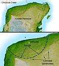 | Shaded Relief with Height as Color, Yucatan Peninsula, Mexico". Shuttle Radar Topography Mission. NASA. Archived from the original on March 13, 2017. Retrieved... 82 KB (8,186 words) - 23:00, 24 April 2024 |
 | for the Space Shuttle Launch on Need (LON) missions to be launched on short notice for STS-114 and STS-121, in the event that the shuttle became disabled... 124 KB (4,414 words) - 16:46, 3 May 2024 |
 | (scatterometer, United States, 1999-2008) Shuttle Imaging Radar on the Shuttle Radar Topography Mission (SAR, United States, 2000) Envisat (SAR, altimeter, European... 10 KB (1,334 words) - 15:00, 22 December 2023 |
 | Remote-Sensing Satellite (ERS, 1991) using the same method, the Shuttle Radar Topography Mission (SRTM, 2000) using single-pass SAR and the Advanced Spaceborne... 30 KB (3,236 words) - 14:45, 26 February 2024 |