 | Rothaar Mountains (redirect from Rothaargebirge) The Rothaar Mountains (German: Rothaargebirge, pronounced [ˈʁoːthaːɐ̯ɡəˌbɪʁɡə] , also Rotlagergebirge), or Rothaar, is a low mountain range reaching heights... 7 KB (605 words) - 20:37, 4 April 2024 |
Hohe Warte (Rothaar) (redirect from Hohe Warte (Rothaargebirge)) [[:de:Hohe Warte (Rothaargebirge)]]; see its history for attribution. You may also add the template {{Translated|de|Hohe Warte (Rothaargebirge)}} to the talk... 703 bytes (32 words) - 02:36, 1 December 2022 |
 | 6 km), and Rhineland-Palatinate (57.0 km). It has its source in the Rothaargebirge, the highest part of the Sauerland. It meets the Rhine at Lahnstein... 35 KB (3,791 words) - 13:05, 15 September 2023 |
Bremberg (Rothaar) (redirect from Bremberg (Rothaargebirge)) 8°29′43″E / 51.1895667°N 8.4951528°E / 51.1895667; 8.4951528 Geography Location Sauerland, North Rhine-Westphalia, Germany Parent range Rothaargebirge... 2 KB (146 words) - 20:12, 14 November 2022 |
 | as well as the left-Rhenish Eifel in the southwest of the state. The Rothaargebirge in the border region with Hesse rises to height of about 800 m above... 68 KB (5,616 words) - 21:16, 6 May 2024 |
 | forest might not cover all of the protected area. "Naturpark Sauerland Rothaargebirge" (in German). Retrieved 11 September 2019. "Le Parc naturel des deux... 15 KB (556 words) - 12:09, 16 April 2024 |
November 2018. Kerber, Malte (12 July 2017). Eine Wanderung über das Rothaargebirge und durch den Westerwald: Notizenbuch. Engelsdorfer Verlag. ISBN 9783961451395... 7 KB (403 words) - 03:40, 5 May 2024 |
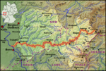
| Map of the Lahn river from its source in the Rothaargebirge to its mouth near Koblenz... 18 KB (2,542 words) - 09:06, 15 September 2023 |
 | Langenberg (Rothaar) (redirect from Langenberg (Rothaargebirge)) The Langenberg (German pronunciation: [ˈlaŋənˌbɛʁk] ) rises on the state border between North Rhine-Westphalia and Hesse in Germany and, at 843.2 m above sea... 5 KB (543 words) - 23:46, 3 January 2024 |
 | It is 155 kilometres (96 mi) in length. The source is located in the Rothaargebirge mountains. From here the river runs southwestwards to the city of Siegen... 3 KB (262 words) - 21:32, 26 April 2024 |