 | The Lauca River is a binational river. It originates in the Chilean Altiplano of the Arica and Parinacota Region, crosses the Andes and empties into Coipasa... 5 KB (415 words) - 14:22, 29 November 2023 |
(Rio Lauca, Río Lauca) • (BO) Rio ChusjavidaRío Chusjavida • 18°34′17″S 69°09′43″W / 18.57142°S 69.16196°W / -18.57142; -69.16196 (Río Chusjavida) •... 13 KB (1,286 words) - 03:20, 8 March 2022 |
 | The Canal Lauca is an artificial channel to divert the waters of the Lauca River westward through a canal and tunnel into the Azapa Valley for purposes... 5 KB (541 words) - 00:29, 18 April 2022 |
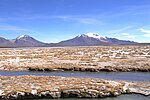
 | metres (14,820 ft), in the Altiplano of Arica y Parinacota Region in the Lauca National Park. It has a surface area of about 21.5–22.5 square kilometres... 28 KB (3,052 words) - 22:56, 3 January 2024 |
Incallajta Iskanwaya Puma Punku Lukurmata Sacambaya River Alcaya Jachaphasa Río Lauca Chullpas Tiahuanaco also known as Tiwanaku Bijela Tabija Butmir Daorson... 75 KB (6,377 words) - 02:58, 26 March 2024 |
 | Lake Chungará; numerous other lakes now forming the headwaters of the Rio Lauca sprang up within the deposit. Volcanic activity rebuilt the cone after... 79 KB (9,426 words) - 13:13, 15 January 2024 |
 | (August 2015). "DIAGNÓSTICO DE DISPONIBILIDAD HÍDRICA EN LA CUENCA DEL RÍO LAUCA, REGIÓN DE ARICA Y PARINACOTA" (PDF). Dirección General de Aguas (in Spanish)... 9 KB (876 words) - 00:54, 7 December 2023 |
 | 19°12′S 68°07′W / 19.200°S 68.117°W / -19.200; -68.117 Primary inflows Río Lauca Basin countries Bolivia Surface area 806 km2 (311 sq mi) Max. depth 3... 3 KB (191 words) - 14:27, 29 November 2023 |
 | westward from the Andes to the Pacific Ocean between the Río Salado on the south and the Río Loa on the north, which included part of the Atacama Desert... 26 KB (3,983 words) - 06:47, 25 December 2023 |
 | Gisbert, Teresa (1994). "El señorío de los Carangas y los chullpares del Río Lauca" (PDF) (in Spanish). Centro Bartolome de Las Casas. p. 433. Retrieved... 18 KB (2,137 words) - 17:02, 22 December 2022 |