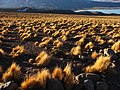
 | very low rainfall of 76 mm (3.0 in) annually. Two communities, Quetena Chico and Quetena Grande, lie within the reserve. Lakes include Laguna Verde, Laguna... 20 KB (2,277 words) - 07:05, 13 April 2024 |
 | KFe3+3(SO4)2(OH)6, and cuprian melanterite (pisanite), (Fe2+,Cu2+)SO4·7H2O, at Quetena, Chile. Warr, L.N. (2021). "IMA–CNMNC approved mineral symbols". Mineralogical... 3 KB (211 words) - 16:44, 9 January 2024 |
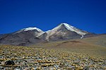
 | eruption metres feet Coordinates Quetena 5730 18799 22°15′S 67°25′W / 22.25°S 67.42°W / -22.25; -67.42 (Quetena) Unknown Ray Mountain 2050 6730 52°14′N... 11 KB (683 words) - 12:40, 14 April 2024 |
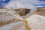 | geothermal fields in the world. The nearest major communities are Quetena Grande and Quetena Chico in Bolivia, 75 kilometres (47 mi) northeast from Sol de... 18 KB (1,938 words) - 07:37, 10 February 2024 |
 | 433 (Pumiri) Holocene? Quetena 5730 18,794 22°15′33″S 67°24′56″W / 22.25917°S 67.41556°W / -22.25917; -67.41556 (Quetena) Holocene? Sacabaya (or:Quemado)... 11 KB (258 words) - 19:34, 9 November 2023 |
 | San Vicente, Tacmari Sur Lípez San Pablo de Lípez San Pablo de Lípez Quetena Grande, San Antonio de Lípez, San Pablo de Lípez San Antonio de Esmoruco... 53 KB (53 words) - 01:29, 22 December 2023 |
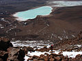
bordered by the Laguna Colorada to the west, Cerro Torque in the north and Quetena to the east; Laguna Colorada is also the origin of the name of the shield... 8 KB (872 words) - 07:55, 5 February 2024 |
Institute of Geophysics, France, in the year 1961. Its type locality is Queténa Mine, Toki Cu deposit, Chuquicamata District, Calama, El Loa Province,... 3 KB (131 words) - 03:38, 3 October 2023 |
 | of 230 km and an average width of 100 km. In its southwestern part, the Quetena Grande Canton lies in the Eduardo Avaroa Andean Fauna National Reserve... 11 KB (469 words) - 22:11, 26 May 2023 |
 | municipality of the Sur Lípez area of southern Bolivia, southeast of the town of Quetena and just northeast of the Eduardo Avaroa Andean Fauna National Reserve... 75 KB (7,884 words) - 23:42, 5 January 2024 |